Austral elevation
Austral (New South Wales, Liverpool), Australia elevation is 75 meters and Austral elevation in feet is 246 ft above sea level [src 1]. Austral is a section of populated place (feature code) with elevation that is 38 meters (125 ft) smaller than average city elevation in Australia.
Below is the Elevation map of Austral, which displays elevation range with different colors. Scale of the first map is from 31 to 120 m (102 to 394 ft) with average elevation of 72 meters (=236 ft) [note 1]
These maps also provides idea of topography and contour of this city, they are displayed at different zoom levels. More info about maps, scale and edge coordinates you can find below images.
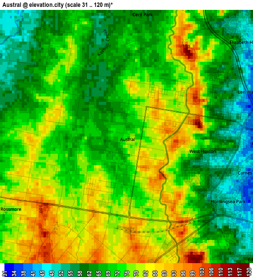
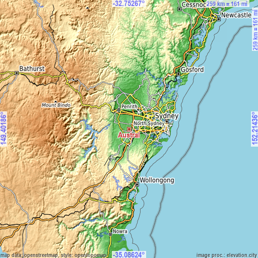
| \ | Map #1 | Topo.Map |
| Scale [m] | 31..120 m | × |
| Scale [ft] | 102..394 ft | × |
| Average | 72 m = 236 ft | × |
| Width | 8.11 km = 5 mi | 259.5 km = 161.2 mi |
| Height | 8.11 km = 5 mi | 259.5 km = 161.2 mi |
| ↑Max Latitude | -33.890979° | -32.75267° |
| Latitude at center | -33.92745° | -33.92745° |
| ↓Min Latitude | -33.963906° | -35.08624° |
| ← Min Longitude | 150.764165° | 149.40186° |
| Longitude center | 150.80811° | 150.80811° |
| →Max Longitude | 150.852055° | 152.21436° |
Nearby cities:
Cities around Austral sort by population:
• Green Valley elevation 72 m
6.1 km,  63°
63°
• Hinchinbrook 40 m
5.2 km,  79°
79°
• West Hoxton 37 m
2.3 km,  107°
107°
• Cecil Hills 63 m
5.8 km,  43°
43°
• Middleton Grange 64 m
3.3 km,  69°
69°
• Hoxton Park 37 m
4.3 km,  95°
95°
• Horningsea Park 44 m
3.9 km,  117°
117°
• Leppington 106 m
4.8 km,  192°
192°
• Elizabeth Hills 48 m
4.9 km,  48°
48°
• Edmondson Park 44 m
5.9 km, 123°
• Kemps Creek 69 m
5.5 km,  340°
340°
• Carnes Hill 42 m
3.9 km, 108°
Multilingual:
 En español:
Austral elevación 75 m.
 En France:
Austral élévation 75 m.


Sources and notes:
- [note 1] Map square and city borders are not equal. Map elevation data is calculated only from area inside that square.
- [src 1] Elevation data from geonames database provided with same terms of usage.
- [src 2] The elevation map of Austral is generated using elevation data from NASA's 3 arcsec (90m) resolution SRTM data.
- [src 3] Base (background) map © OpenStreetMap contributors tiles are generated by Geofabrik and OpenTopoMap.
Copyright & License:
This Austral Elevation Map is licensed under CC BY-SA. You may reuse any part from this page, if you give a proper credit by linking to this URL:
 More info on terms of use page.