Herne Hill elevation
Herne Hill (Victoria, Greater Geelong), Australia elevation is 54 meters and Herne Hill elevation in feet is 177 ft above sea level [src 1]. Herne Hill is a section of populated place (feature code) with elevation that is 59 meters (194 ft) smaller than average city elevation in Australia.
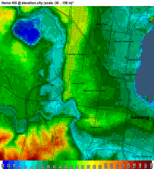
Below is the Elevation map of Herne Hill, which displays elevation range with different colors. Scale of the first map is from -30 to 158 m (-98 to 518 ft) with average elevation of 38.1 meters (=125 ft) [note 1]
These maps also provides idea of topography and contour of this city, they are displayed at different zoom levels. More info about maps, scale and edge coordinates you can find below images.
| \ | Map #1 | Topo.Map |
| Scale [m] | -30..158 m | × |
| Scale [ft] | -98..518 ft | × |
| Average | 38.1 m = 125 ft | × |
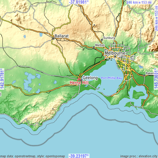
| Width | 7.69 km = 4.8 mi | 246 km = 152.9 mi |
| Height | 7.69 km = 4.8 mi | 246 km = 152.9 mi |
| ↑Max Latitude | -38.099696° | -37.01981° |
| Latitude at center | -38.13427° | -38.13427° |
| ↓Min Latitude | -38.168828° | -39.23197° |
| ← Min Longitude | 144.280115° | 142.91781° |
| Longitude center | 144.32406° | 144.32406° |
| →Max Longitude | 144.368005° | 145.73031° |
Nearby cities:
Cities around Herne Hill sort by population:
• Geelong elevation 6 m
3.5 km,  114°
114°
• Highton 60 m
4.2 km,  195°
195°
• Newtown 57 m
2.4 km,  156°
156°
• Norlane 14 m
4.5 km,  35°
35°
• Geelong West 26 m
2.2 km,  103°
103°
• Hamlyn Heights 42 m
1.5 km,  13°
13°
• Geelong city centre 24 m
3.7 km,  117°
117°
• Bell Park 25 m
3.2 km,  23°
23°
• Bell Post Hill 69 m
4.3 km,  354°
354°
• East Geelong 24 m
4.8 km, 119°
• North Geelong 15 m
3.6 km, 40°
• Manifold Heights 54 m
0.9 km, 113°
Multilingual:
 En español:
Herne Hill elevación 54 m.
 En France:
Herne Hill élévation 54 m.
 Auf Deutsch:
Herne Hill höhe über dem Meeresspiegel ist 54 m.

Sources and notes:
- [note 1] Map square and city borders are not equal. Map elevation data is calculated only from area inside that square.
- [src 1] Elevation data from geonames database provided with same terms of usage.
- [src 2] The elevation map of Herne Hill is generated using elevation data from NASA's 3 arcsec (90m) resolution SRTM data.
- [src 3] Base (background) map © OpenStreetMap contributors tiles are generated by Geofabrik and OpenTopoMap.
Copyright & License:
This Herne Hill Elevation Map is licensed under CC BY-SA. You may reuse any part from this page, if you give a proper credit by linking to this URL:
 More info on terms of use page.