Trevallyn elevation
Trevallyn (Tasmania, West Tamar), Australia elevation is 204 meters and Trevallyn elevation in feet is 669 ft above sea level [src 1]. Trevallyn is a section of populated place (feature code) with elevation that is 91 meters (299 ft) bigger than average city elevation in Australia.
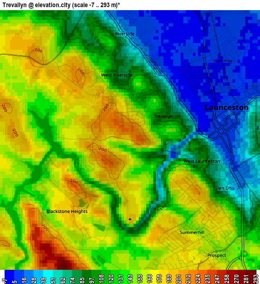
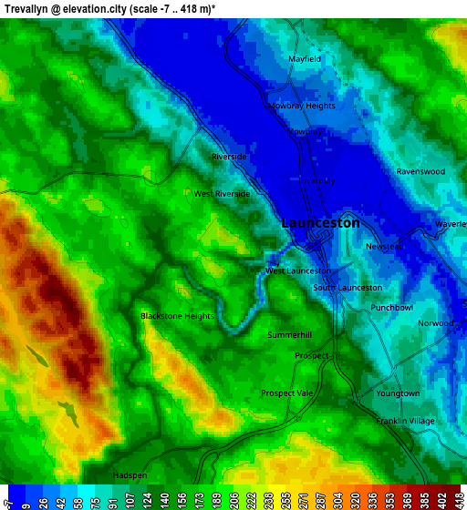
Below is the Elevation map of Trevallyn, which displays elevation range with different colors. Scale of the first map is from -7 to 293 m (-23 to 961 ft) with average elevation of 120.8 meters (=396 ft) [note 1]
These maps also provides idea of topography and contour of this city, they are displayed at different zoom levels. More info about maps, scale and edge coordinates you can find below images.
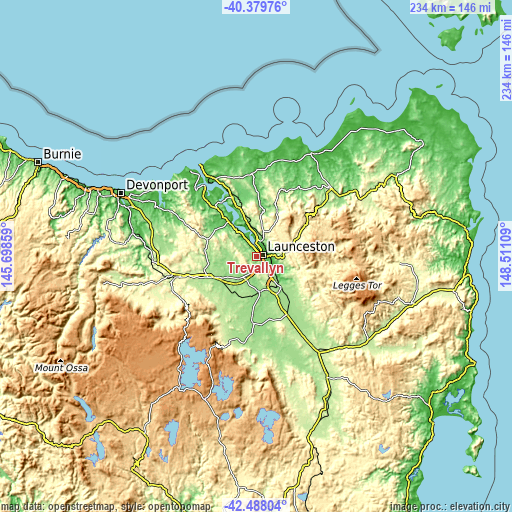
| \ | Map #1 | Map #2 | Topo.Map |
| Scale [m] | -7..293 m | -7..418 m | × |
| Scale [ft] | -23..961 ft | -23..1371 ft | × |
| Average | 120.8 m = 396 ft | 135.9 m = 446 ft | × |
| Width | 7.33 km = 4.6 mi | 14.65 km = 9.1 mi | 234.4 km = 145.6 mi |
| Height | 7.33 km = 4.6 mi | 14.65 km = 9.1 mi | 234.4 km = 145.6 mi |
| ↑Max Latitude | -41.409509° | -41.376542° | -40.37976° |
| Latitude at center | -41.44246° | -41.44246° | -41.44246° |
| ↓Min Latitude | -41.475394° | -41.508311° | -42.48804° |
| ← Min Longitude | 147.060895° | 147.016949° | 145.69859° |
| Longitude center | 147.10484° | 147.10484° | 147.10484° |
| →Max Longitude | 147.148785° | 147.192731° | 148.51109° |
Nearby cities:
Cities around Trevallyn sort by population:
• Launceston elevation 82 m
2.5 km,  80°
80°
• Riverside 139 m
5.1 km,  297°
297°
• Prospect Vale 185 m
4.3 km,  180°
180°
• Newstead 9 m
4.8 km,  88°
88°
• South Launceston 46 m
3.7 km,  112°
112°
• West Launceston 78 m
2.4 km, 113°
• Launceston city centre 24 m
2.9 km,  70°
70°
• Kings Meadows 68 m
5.7 km,  123°
123°
• Invermay 6 m
3.4 km,  44°
44°
• Summerhill 163 m
3.4 km,  145°
145°
• East Launceston 40 m
3.9 km, 83°
• Blackstone Heights 188 m
2.6 km,  221°
221°
Multilingual:
 En español:
Trevallyn elevación 204 m.
 En France:
Trevallyn élévation 204 m.
 Auf Deutsch:
Trevallyn höhe über dem Meeresspiegel ist 204 m.

Sources and notes:
- [note 1] Map square and city borders are not equal. Map elevation data is calculated only from area inside that square.
- [src 1] Elevation data from geonames database provided with same terms of usage.
- [src 2] The elevation map of Trevallyn is generated using elevation data from NASA's 3 arcsec (90m) resolution SRTM data.
- [src 3] Base (background) map © OpenStreetMap contributors tiles are generated by Geofabrik and OpenTopoMap.
Copyright & License:
This Trevallyn Elevation Map is licensed under CC BY-SA. You may reuse any part from this page, if you give a proper credit by linking to this URL:
 More info on terms of use page.