Tamarama elevation
Tamarama (New South Wales, Waverley), Australia elevation is 40 meters and Tamarama elevation in feet is 131 ft above sea level [src 1]. Tamarama is a section of populated place (feature code) with elevation that is 73 meters (240 ft) smaller than average city elevation in Australia.
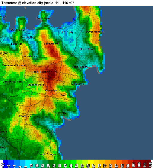
Below is the Elevation map of Tamarama, which displays elevation range with different colors. Scale of the first map is from -11 to 116 m (-36 to 381 ft) with average elevation of 45.5 meters (=149 ft) [note 1]
These maps also provides idea of topography and contour of this city, they are displayed at different zoom levels. More info about maps, scale and edge coordinates you can find below images.
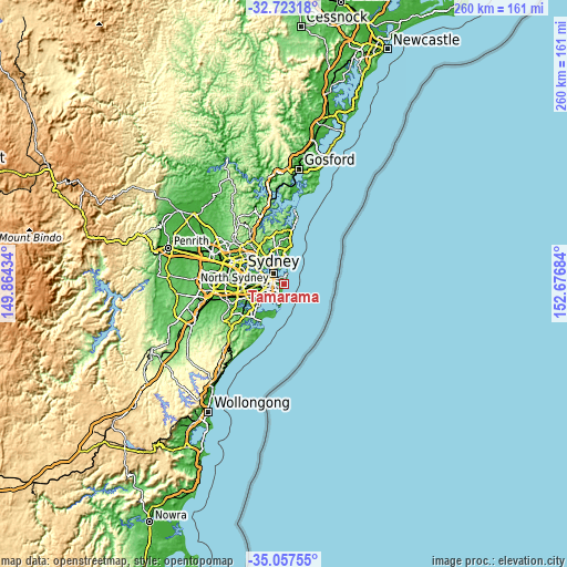
| \ | Map #1 | Topo.Map |
| Scale [m] | -11..116 m | × |
| Scale [ft] | -36..381 ft | × |
| Average | 45.5 m = 149 ft | × |
| Width | 8.11 km = 5 mi | 259.6 km = 161.3 mi |
| Height | 8.11 km = 5 mi | 259.6 km = 161.3 mi |
| ↑Max Latitude | -33.861866° | -32.72318° |
| Latitude at center | -33.89835° | -33.89835° |
| ↓Min Latitude | -33.934818° | -35.05755° |
| ← Min Longitude | 151.226645° | 149.86434° |
| Longitude center | 151.27059° | 151.27059° |
| →Max Longitude | 151.314535° | 152.67684° |
Nearby cities:
Cities around Tamarama sort by population:
• Randwick elevation 40 m
2.7 km,  228°
228°
• Coogee 18 m
2.8 km,  209°
209°
• Bondi Beach 9 m
1.1 km,  41°
41°
• Bellevue Hill 72 m
2.8 km,  319°
319°
• Rose Bay 15 m
3.3 km,  0°
0°
• Bondi 76 m
0.7 km,  308°
308°
• Bondi Junction 94 m
2.2 km,  286°
286°
• North Bondi 20 m
1.5 km, 38°
• Bronte 36 m
0.6 km, 228°
• Clovelly 47 m
1.9 km,  215°
215°
• Dover Heights 61 m
3.2 km,  14°
14°
• Queens Park 58 m
2.2 km,  266°
266°
Multilingual:
 En español:
Tamarama elevación 40 m.
 En France:
Tamarama élévation 40 m.


Sources and notes:
- [note 1] Map square and city borders are not equal. Map elevation data is calculated only from area inside that square.
- [src 1] Elevation data from geonames database provided with same terms of usage.
- [src 2] The elevation map of Tamarama is generated using elevation data from NASA's 3 arcsec (90m) resolution SRTM data.
- [src 3] Base (background) map © OpenStreetMap contributors tiles are generated by Geofabrik and OpenTopoMap.
Copyright & License:
This Tamarama Elevation Map is licensed under CC BY-SA. You may reuse any part from this page, if you give a proper credit by linking to this URL:
 More info on terms of use page.