O'Connor elevation
O'Connor (ACT), Australia elevation is 621 meters and O'Connor elevation in feet is 2037 ft above sea level [src 1]. O'Connor is a section of populated place (feature code) with elevation that is 508 meters (1667 ft) bigger than average city elevation in Australia.
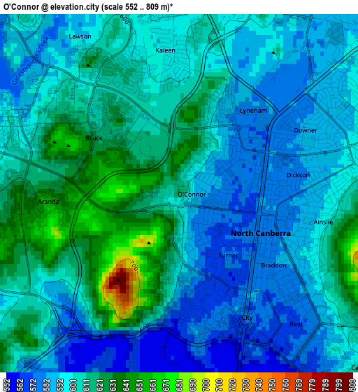
Below is the Elevation map of O'Connor, which displays elevation range with different colors. Scale of the first map is from 552 to 809 m (1811 to 2654 ft) with average elevation of 601.4 meters (=1973 ft) [note 1]
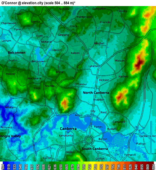
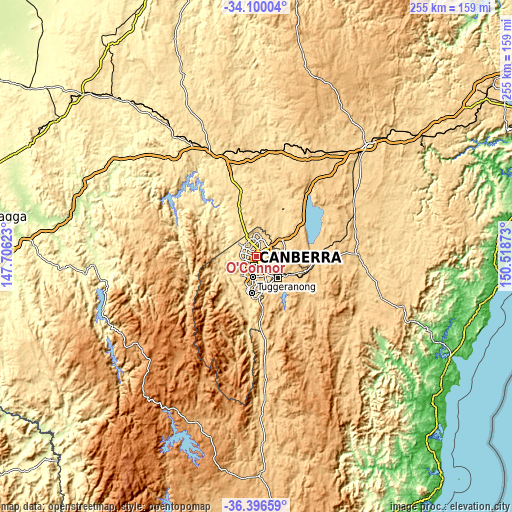
These maps also provides idea of topography and contour of this city, they are displayed at different zoom levels. More info about maps, scale and edge coordinates you can find below images.
| \ | Map #1 | Map #2 | Topo.Map |
| Scale [m] | 552..809 m | 504..884 m | × |
| Scale [ft] | 1811..2654 ft | 1654..2900 ft | × |
| Average | 601.4 m = 1973 ft | 604 m = 1982 ft | × |
| Width | 7.98 km = 5 mi | 15.96 km = 9.9 mi | 255.4 km = 158.7 mi |
| Height | 7.98 km = 5 mi | 15.96 km = 9.9 mi | 255.4 km = 158.7 mi |
| ↑Max Latitude | -35.220557° | -35.184649° | -34.10004° |
| Latitude at center | -35.25645° | -35.25645° | -35.25645° |
| ↓Min Latitude | -35.292327° | -35.328188° | -36.39659° |
| ← Min Longitude | 149.068535° | 149.024589° | 147.70623° |
| Longitude center | 149.11248° | 149.11248° | 149.11248° |
| →Max Longitude | 149.156425° | 149.200371° | 150.51873° |
Nearby cities:
Cities around O'Connor sort by population:
• Canberra elevation 571 m
3.3 km,  154°
154°
• Bruce 618 m
2.4 km,  305°
305°
• Braddon 582 m
2.6 km,  127°
127°
• City 578 m
3.2 km, 151°
• Lyneham 580 m
2.5 km,  41°
41°
• Ainslie 586 m
2.9 km,  103°
103°
• Turner 576 m
1.8 km,  141°
141°
• Downer 586 m
3.2 km,  65°
65°
• Dickson 579 m
2.5 km,  75°
75°
• Acton 566 m
2.4 km,  167°
167°
• Aranda 652 m
2.9 km,  266°
266°
• Reid 572 m
4.1 km, 143°
Multilingual:
 En español:
O'Connor elevación 621 m.
 En France:
O'Connor élévation 621 m.
 Auf Deutsch:
O'Connor höhe über dem Meeresspiegel ist 621 m.

Sources and notes:
- [note 1] Map square and city borders are not equal. Map elevation data is calculated only from area inside that square.
- [src 1] Elevation data from geonames database provided with same terms of usage.
- [src 2] The elevation map of O'Connor is generated using elevation data from NASA's 3 arcsec (90m) resolution SRTM data.
- [src 3] Base (background) map © OpenStreetMap contributors tiles are generated by Geofabrik and OpenTopoMap.
Copyright & License:
This O'Connor Elevation Map is licensed under CC BY-SA. You may reuse any part from this page, if you give a proper credit by linking to this URL:
 More info on terms of use page.