Manoora elevation
Manoora (Queensland, Cairns), Australia elevation is 10 meters and Manoora elevation in feet is 33 ft above sea level [src 1]. Manoora is a section of populated place (feature code) with elevation that is 103 meters (338 ft) smaller than average city elevation in Australia.
Below is the Elevation map of Manoora, which displays elevation range with different colors. Scale of the first map is from -3 to 608 m (-10 to 1995 ft) with average elevation of 67.2 meters (=220 ft) [note 1]
These maps also provides idea of topography and contour of this city, they are displayed at different zoom levels. More info about maps, scale and edge coordinates you can find below images.
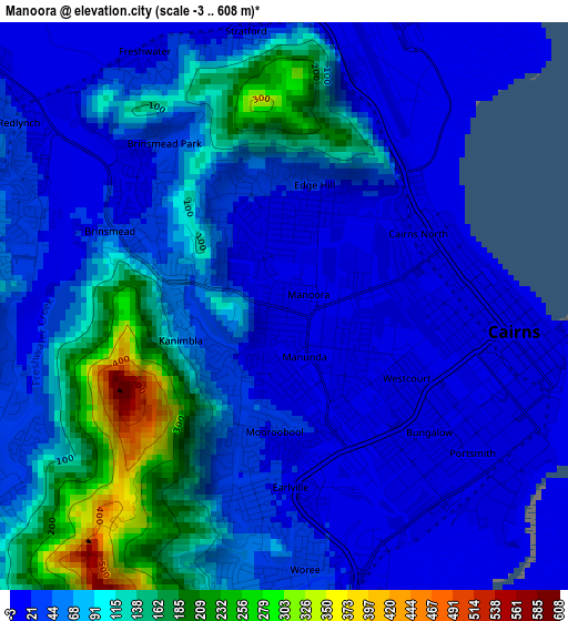
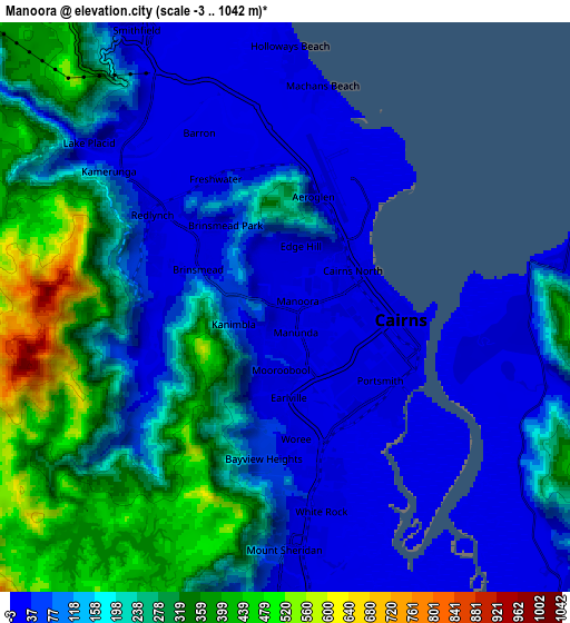
| \ | Map #1 | Map #2 | Topo.Map |
| Scale [m] | -3..608 m | -3..1042 m | × |
| Scale [ft] | -10..1995 ft | -10..3419 ft | × |
| Average | 67.2 m = 220 ft | 168.4 m = 552 ft | × |
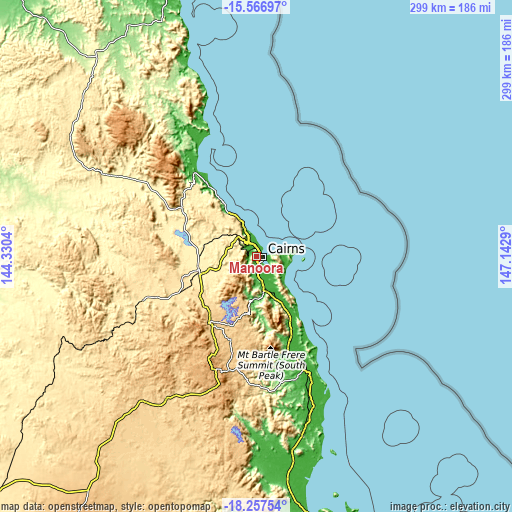
| Width | 9.35 km = 5.8 mi | 18.7 km = 11.6 mi | 299.2 km = 185.9 mi |
| Height | 9.35 km = 5.8 mi | 18.7 km = 11.6 mi | 299.2 km = 185.9 mi |
| ↑Max Latitude | -16.875012° | -16.832954° | -15.56697° |
| Latitude at center | -16.91706° | -16.91706° | -16.91706° |
| ↓Min Latitude | -16.959099° | -17.001129° | -18.25754° |
| ← Min Longitude | 145.692705° | 145.648759° | 144.3304° |
| Longitude center | 145.73665° | 145.73665° | 145.73665° |
| →Max Longitude | 145.780595° | 145.824541° | 147.1429° |
Nearby cities:
Cities around Manoora sort by population:
• Cairns elevation 1 m
3.2 km,  103°
103°
• Cairns North 7 m
2.6 km,  56°
56°
• Mooroobool 24 m
2.1 km,  195°
195°
• Manunda 15 m
1.3 km,  90°
90°
• Brinsmead 21 m
3 km,  311°
311°
• Whitfield 48 m
2.5 km,  351°
351°
• Earlville 39 m
3.8 km,  185°
185°
• Westcourt 7 m
2.3 km,  130°
130°
• Edge Hill 16 m
2.4 km,  36°
36°
• Parramatta Park 7 m
3.3 km,  107°
107°
• Kanimbla 50 m
1.7 km,  247°
247°
• Bungalow 4 m
3.2 km,  138°
138°
Multilingual:
 En español:
Manoora elevación 10 m.
 En France:
Manoora élévation 10 m.


Sources and notes:
- [note 1] Map square and city borders are not equal. Map elevation data is calculated only from area inside that square.
- [src 1] Elevation data from geonames database provided with same terms of usage.
- [src 2] The elevation map of Manoora is generated using elevation data from NASA's 3 arcsec (90m) resolution SRTM data.
- [src 3] Base (background) map © OpenStreetMap contributors tiles are generated by Geofabrik and OpenTopoMap.
Copyright & License:
This Manoora Elevation Map is licensed under CC BY-SA. You may reuse any part from this page, if you give a proper credit by linking to this URL:
 More info on terms of use page.