Mickleham elevation
Mickleham (Victoria, Hume), Australia elevation is 256 meters and Mickleham elevation in feet is 840 ft above sea level [src 1]. Mickleham is a section of populated place (feature code) with elevation that is 143 meters (469 ft) bigger than average city elevation in Australia.
Below is the Elevation map of Mickleham, which displays elevation range with different colors. Scale of the first map is from 158 to 309 m (518 to 1014 ft) with average elevation of 243.8 meters (=800 ft) [note 1]
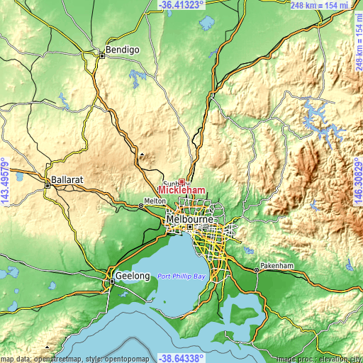
These maps also provides idea of topography and contour of this city, they are displayed at different zoom levels. More info about maps, scale and edge coordinates you can find below images.
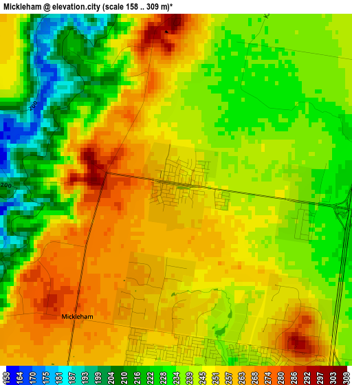
| \ | Map #1 | Topo.Map |
| Scale [m] | 158..309 m | × |
| Scale [ft] | 518..1014 ft | × |
| Average | 243.8 m = 800 ft | × |
| Width | 7.75 km = 4.8 mi | 248 km = 154.1 mi |
| Height | 7.75 km = 4.8 mi | 248 km = 154.1 mi |
| ↑Max Latitude | -37.501785° | -36.41323° |
| Latitude at center | -37.53664° | -37.53664° |
| ↓Min Latitude | -37.571479° | -38.64338° |
| ← Min Longitude | 144.858095° | 143.49579° |
| Longitude center | 144.90204° | 144.90204° |
| →Max Longitude | 144.945985° | 146.30829° |
Nearby cities:
Cities around Mickleham sort by population:
• Craigieburn elevation 186 m
8.2 km,  149°
149°
• Roxburgh Park 188 m
10.1 km,  168°
168°
• Greenvale 155 m
11.2 km,  196°
196°
• Meadow Heights 137 m
12.8 km, 173°
• Wallan 321 m
15 km,  26°
26°
• Wollert 199 m
12.7 km,  114°
114°
• Dallas 137 m
15.2 km, 168°
• Westmeadows 81 m
15.6 km,  184°
184°
• Campbellfield 117 m
15 km,  160°
160°
• Attwood 116 m
14.8 km,  185°
185°
• Coolaroo 148 m
13.7 km, 167°
• Beveridge 273 m
9.3 km,  50°
50°
Multilingual:
 En español:
Mickleham elevación 256 m.
 En France:
Mickleham élévation 256 m.
 Auf Deutsch:
Mickleham höhe über dem Meeresspiegel ist 256 m.

Sources and notes:
- [note 1] Map square and city borders are not equal. Map elevation data is calculated only from area inside that square.
- [src 1] Elevation data from geonames database provided with same terms of usage.
- [src 2] The elevation map of Mickleham is generated using elevation data from NASA's 3 arcsec (90m) resolution SRTM data.
- [src 3] Base (background) map © OpenStreetMap contributors tiles are generated by Geofabrik and OpenTopoMap.
Copyright & License:
This Mickleham Elevation Map is licensed under CC BY-SA. You may reuse any part from this page, if you give a proper credit by linking to this URL:
 More info on terms of use page.