Payneham South elevation
Payneham South (South Australia, Norwood Payneham St Peters), Australia elevation is 65 meters and Payneham South elevation in feet is 213 ft above sea level [src 1]. Payneham South is a section of populated place (feature code) with elevation that is 48 meters (157 ft) smaller than average city elevation in Australia.
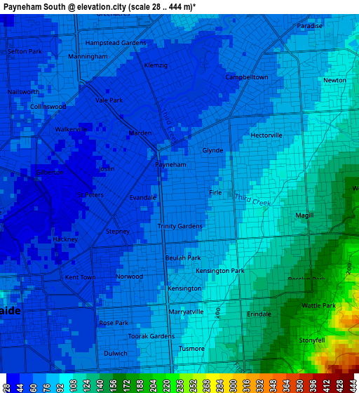
Below is the Elevation map of Payneham South, which displays elevation range with different colors. Scale of the first map is from 28 to 444 m (92 to 1457 ft) with average elevation of 84 meters (=276 ft) [note 1]
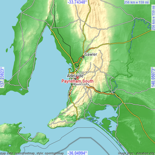
These maps also provides idea of topography and contour of this city, they are displayed at different zoom levels. More info about maps, scale and edge coordinates you can find below images.
| \ | Map #1 | Topo.Map |
| Scale [m] | 28..444 m | × |
| Scale [ft] | 92..1457 ft | × |
| Average | 84 m = 276 ft | × |
| Width | 8.01 km = 5 mi | 256.5 km = 159.4 mi |
| Height | 8.01 km = 5 mi | 256.5 km = 159.4 mi |
| ↑Max Latitude | -34.868762° | -33.74348° |
| Latitude at center | -34.90481° | -34.90481° |
| ↓Min Latitude | -34.940842° | -36.04994° |
| ← Min Longitude | 138.600535° | 137.23823° |
| Longitude center | 138.64448° | 138.64448° |
| →Max Longitude | 138.688425° | 140.05073° |
Nearby cities:
Cities around Payneham South sort by population:
• Tranmere elevation 97 m
1.6 km,  92°
92°
• Marden 57 m
1.2 km,  329°
329°
• Payneham 60 m
0.9 km,  337°
337°
• Glynde 70 m
1.2 km,  37°
37°
• Beulah Park 75 m
1.4 km,  177°
177°
• St Morris 81 m
1.1 km,  129°
129°
• Maylands 60 m
1 km,  224°
224°
• Firle 77 m
0.8 km, 88°
• Evandale 57 m
0.8 km,  264°
264°
• Trinity Gardens 65 m
1.1 km,  194°
194°
• Royston Park 55 m
1.4 km,  304°
304°
• Joslin 43 m
1.7 km,  289°
289°
Multilingual:
 En español:
Payneham South elevación 65 m.
 En France:
Payneham South élévation 65 m.
 Auf Deutsch:
Payneham South höhe über dem Meeresspiegel ist 65 m.

Sources and notes:
- [note 1] Map square and city borders are not equal. Map elevation data is calculated only from area inside that square.
- [src 1] Elevation data from geonames database provided with same terms of usage.
- [src 2] The elevation map of Payneham South is generated using elevation data from NASA's 3 arcsec (90m) resolution SRTM data.
- [src 3] Base (background) map © OpenStreetMap contributors tiles are generated by Geofabrik and OpenTopoMap.
Copyright & License:
This Payneham South Elevation Map is licensed under CC BY-SA. You may reuse any part from this page, if you give a proper credit by linking to this URL:
 More info on terms of use page.