Warwick Farm elevation
Warwick Farm (New South Wales, Liverpool), Australia elevation is 12 meters and Warwick Farm elevation in feet is 39 ft above sea level [src 1]. Warwick Farm is a section of populated place (feature code) with elevation that is 101 meters (331 ft) smaller than average city elevation in Australia.
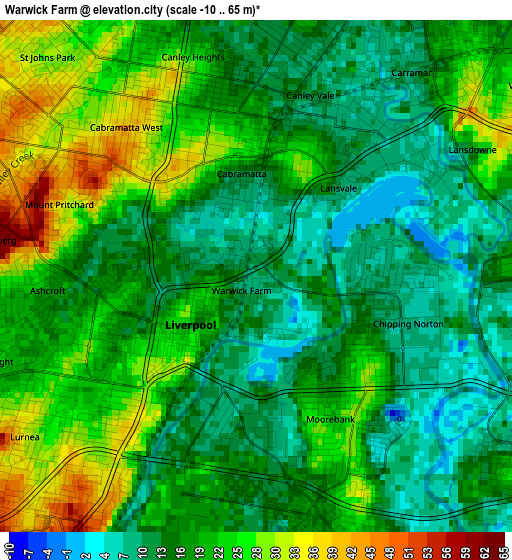
Below is the Elevation map of Warwick Farm, which displays elevation range with different colors. Scale of the first map is from -10 to 65 m (-33 to 213 ft) with average elevation of 18.7 meters (=61 ft) [note 1]
These maps also provides idea of topography and contour of this city, they are displayed at different zoom levels. More info about maps, scale and edge coordinates you can find below images.
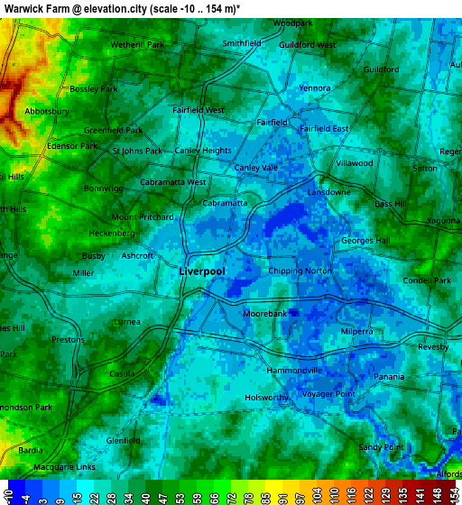
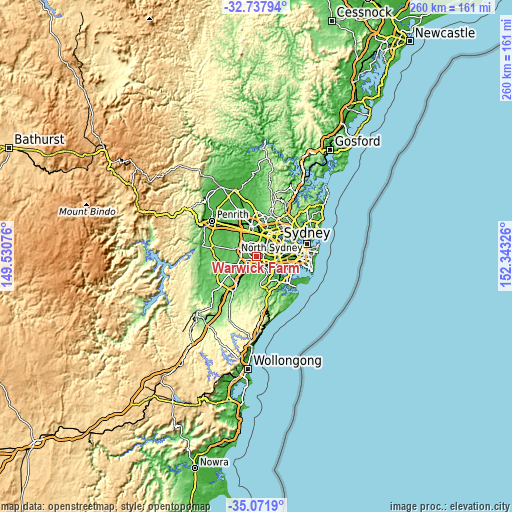
| \ | Map #1 | Map #2 | Topo.Map |
| Scale [m] | -10..65 m | -10..154 m | × |
| Scale [ft] | -33..213 ft | -33..505 ft | × |
| Average | 18.7 m = 61 ft | 32.4 m = 106 ft | × |
| Width | 8.11 km = 5 mi | 16.22 km = 10.1 mi | 259.5 km = 161.2 mi |
| Height | 8.11 km = 5 mi | 16.22 km = 10.1 mi | 259.5 km = 161.2 mi |
| ↑Max Latitude | -33.876433° | -33.83994° | -32.73794° |
| Latitude at center | -33.91291° | -33.91291° | -33.91291° |
| ↓Min Latitude | -33.949372° | -33.985818° | -35.0719° |
| ← Min Longitude | 150.893065° | 150.849119° | 149.53076° |
| Longitude center | 150.93701° | 150.93701° | 150.93701° |
| →Max Longitude | 150.980955° | 151.024901° | 152.34326° |
Nearby cities:
Cities around Warwick Farm sort by population:
• Liverpool elevation 11 m
1.3 km,  234°
234°
• Cabramatta 18 m
1.7 km,  352°
352°
• Canley Heights 28 m
3.6 km,  340°
340°
• Canley Vale 12 m
3.1 km,  19°
19°
• Mount Pritchard 32 m
3.2 km,  290°
290°
• Moorebank 13 m
3.9 km,  152°
152°
• Chipping Norton 15 m
2.1 km,  105°
105°
• Cabramatta West 46 m
3.2 km,  313°
313°
• Ashcroft 18 m
3.4 km,  264°
264°
• Carramar 13 m
3.9 km,  34°
34°
• Hammondville 24 m
4.2 km,  160°
160°
• Lansvale 2 m
1.9 km,  43°
43°
Multilingual:
 En español:
Warwick Farm elevación 12 m.
 En France:
Warwick Farm élévation 12 m.
 Auf Deutsch:
Warwick Farm höhe über dem Meeresspiegel ist 12 m.

Sources and notes:
- [note 1] Map square and city borders are not equal. Map elevation data is calculated only from area inside that square.
- [src 1] Elevation data from geonames database provided with same terms of usage.
- [src 2] The elevation map of Warwick Farm is generated using elevation data from NASA's 3 arcsec (90m) resolution SRTM data.
- [src 3] Base (background) map © OpenStreetMap contributors tiles are generated by Geofabrik and OpenTopoMap.
Copyright & License:
This Warwick Farm Elevation Map is licensed under CC BY-SA. You may reuse any part from this page, if you give a proper credit by linking to this URL:
 More info on terms of use page.