Orangeville elevation
Orangeville (New South Wales, Wollondilly), Australia elevation is 196 meters and Orangeville elevation in feet is 643 ft above sea level [src 1]. Orangeville is a section of populated place (feature code) with elevation that is 83 meters (272 ft) bigger than average city elevation in Australia.
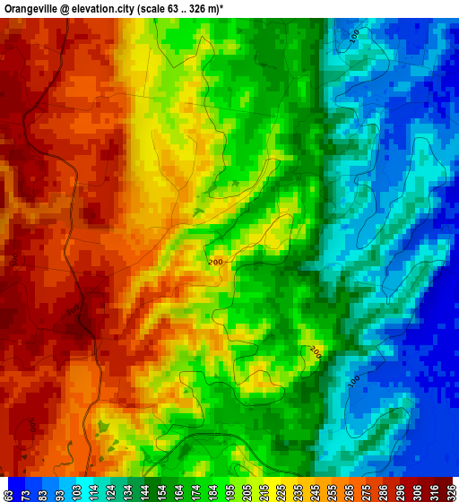
Below is the Elevation map of Orangeville, which displays elevation range with different colors. Scale of the first map is from 63 to 326 m (207 to 1070 ft) with average elevation of 193.7 meters (=635 ft) [note 1]
These maps also provides idea of topography and contour of this city, they are displayed at different zoom levels. More info about maps, scale and edge coordinates you can find below images.
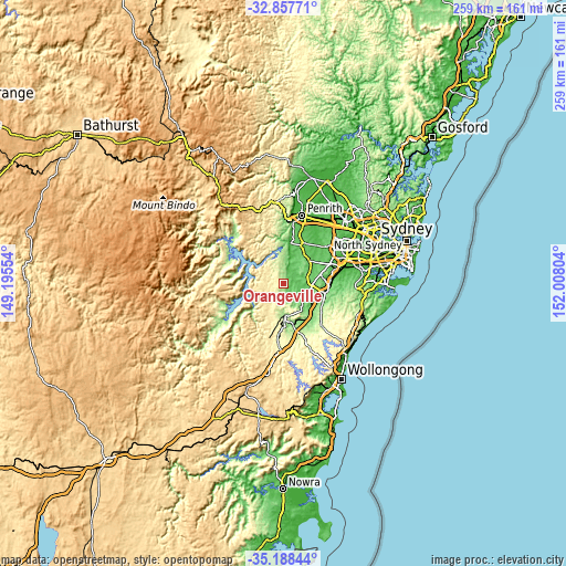
| \ | Map #1 | Topo.Map |
| Scale [m] | 63..326 m | × |
| Scale [ft] | 207..1070 ft | × |
| Average | 193.7 m = 635 ft | × |
| Width | 8.1 km = 5 mi | 259.2 km = 161.1 mi |
| Height | 8.1 km = 5 mi | 259.2 km = 161.1 mi |
| ↑Max Latitude | -33.994653° | -32.85771° |
| Latitude at center | -34.03108° | -34.03108° |
| ↓Min Latitude | -34.067491° | -35.18844° |
| ← Min Longitude | 150.557845° | 149.19554° |
| Longitude center | 150.60179° | 150.60179° |
| →Max Longitude | 150.645735° | 152.00804° |
Nearby cities:
Cities around Orangeville sort by population:
• Harrington Park elevation 80 m
12.3 km,  86°
86°
• Oran Park 104 m
13.1 km,  77°
77°
• Camden South 91 m
10.3 km,  124°
124°
• Spring Farm 82 m
11 km,  112°
112°
• Elderslie 142 m
10.7 km,  104°
104°
• Silverdale 170 m
12.9 km,  3°
3°
• Narellan 83 m
12.1 km, 96°
• Camden 81 m
9.1 km, 106°
• The Oaks 289 m
6.2 km,  208°
208°
• Cobbitty 105 m
7.3 km, 76°
• Grasmere 92 m
6.4 km, 113°
• Oakdale 414 m
9.8 km,  236°
236°
Multilingual:
 En español:
Orangeville elevación 196 m.
 En France:
Orangeville élévation 196 m.
 Auf Deutsch:
Orangeville höhe über dem Meeresspiegel ist 196 m.

Sources and notes:
- [note 1] Map square and city borders are not equal. Map elevation data is calculated only from area inside that square.
- [src 1] Elevation data from geonames database provided with same terms of usage.
- [src 2] The elevation map of Orangeville is generated using elevation data from NASA's 3 arcsec (90m) resolution SRTM data.
- [src 3] Base (background) map © OpenStreetMap contributors tiles are generated by Geofabrik and OpenTopoMap.
Copyright & License:
This Orangeville Elevation Map is licensed under CC BY-SA. You may reuse any part from this page, if you give a proper credit by linking to this URL:
 More info on terms of use page.