Gnangara elevation
Gnangara (Western Australia, Wanneroo), Australia elevation is 48 meters and Gnangara elevation in feet is 157 ft above sea level [src 1]. Gnangara is a section of populated place (feature code) with elevation that is 65 meters (213 ft) smaller than average city elevation in Australia.
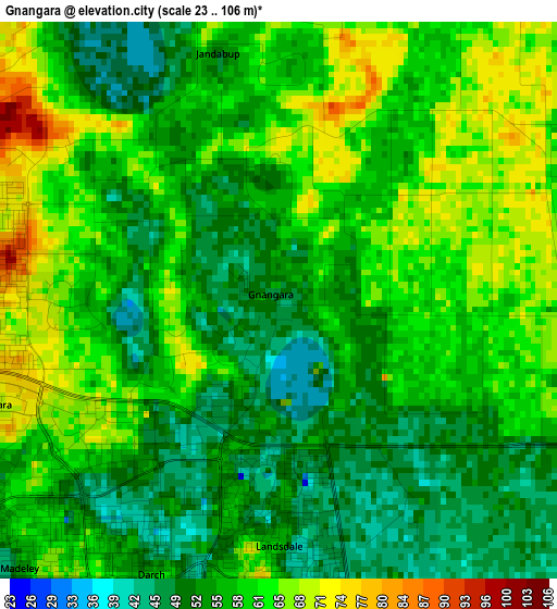
Below is the Elevation map of Gnangara, which displays elevation range with different colors. Scale of the first map is from 23 to 106 m (75 to 348 ft) with average elevation of 57.9 meters (=190 ft) [note 1]
These maps also provides idea of topography and contour of this city, they are displayed at different zoom levels. More info about maps, scale and edge coordinates you can find below images.
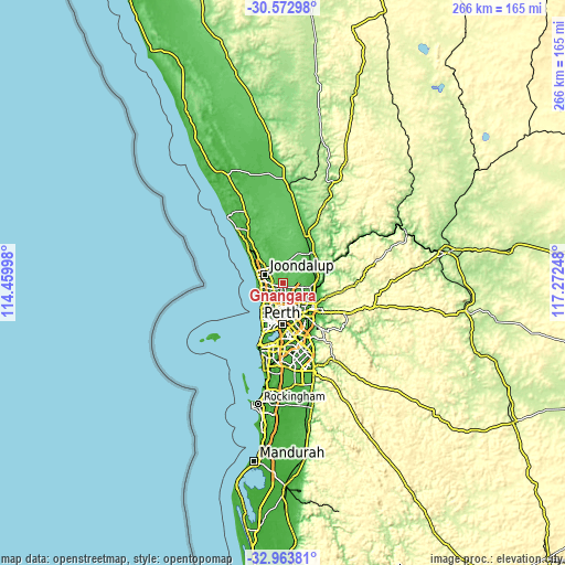
| \ | Map #1 | Topo.Map |
| Scale [m] | 23..106 m | × |
| Scale [ft] | 75..348 ft | × |
| Average | 57.9 m = 190 ft | × |
| Width | 8.31 km = 5.2 mi | 265.8 km = 165.2 mi |
| Height | 8.31 km = 5.2 mi | 265.8 km = 165.2 mi |
| ↑Max Latitude | -31.738754° | -30.57298° |
| Latitude at center | -31.77612° | -31.77612° |
| ↓Min Latitude | -31.813471° | -32.96381° |
| ← Min Longitude | 115.822285° | 114.45998° |
| Longitude center | 115.86623° | 115.86623° |
| →Max Longitude | 115.910175° | 117.27248° |
Nearby cities:
Cities around Gnangara sort by population:
• Kingsley elevation 64 m
7.3 km,  238°
238°
• Landsdale 54 m
3.5 km,  180°
180°
• Wanneroo 43 m
6.9 km,  294°
294°
• Marangaroo 66 m
6.2 km,  204°
204°
• Woodvale 44 m
6.7 km,  257°
257°
• Alexander Heights 74 m
5.7 km, 181°
• Darch 50 m
4.5 km,  205°
205°
• Madeley 59 m
5.3 km,  222°
222°
• Hocking 72 m
4.6 km,  278°
278°
• Koondoola 84 m
7.3 km, 179°
• Pearsall 68 m
4.6 km, 262°
• Sinagra 67 m
6.8 km,  303°
303°
Multilingual:
 En español:
Gnangara elevación 48 m.
 En France:
Gnangara élévation 48 m.


Sources and notes:
- [note 1] Map square and city borders are not equal. Map elevation data is calculated only from area inside that square.
- [src 1] Elevation data from geonames database provided with same terms of usage.
- [src 2] The elevation map of Gnangara is generated using elevation data from NASA's 3 arcsec (90m) resolution SRTM data.
- [src 3] Base (background) map © OpenStreetMap contributors tiles are generated by Geofabrik and OpenTopoMap.
Copyright & License:
This Gnangara Elevation Map is licensed under CC BY-SA. You may reuse any part from this page, if you give a proper credit by linking to this URL:
 More info on terms of use page.