Larapinta elevation
Larapinta (Northern Territory, Alice Springs), Australia elevation is 597 meters and Larapinta elevation in feet is 1959 ft above sea level [src 1]. Larapinta is a section of populated place (feature code) with elevation that is 484 meters (1588 ft) bigger than average city elevation in Australia.
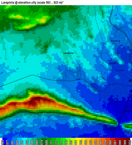
Below is the Elevation map of Larapinta, which displays elevation range with different colors. Scale of the first map is from 563 to 923 m (1847 to 3028 ft) with average elevation of 635.3 meters (=2084 ft) [note 1]
These maps also provides idea of topography and contour of this city, they are displayed at different zoom levels. More info about maps, scale and edge coordinates you can find below images.
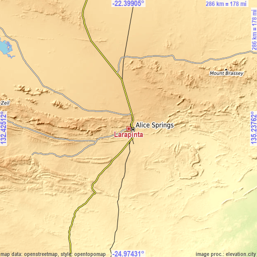
| \ | Map #1 | Topo.Map |
| Scale [m] | 563..923 m | × |
| Scale [ft] | 1847..3028 ft | × |
| Average | 635.3 m = 2084 ft | × |
| Width | 8.95 km = 5.6 mi | 286.3 km = 177.9 mi |
| Height | 8.95 km = 5.6 mi | 286.4 km = 178 mi |
| ↑Max Latitude | -23.652783° | -22.39905° |
| Latitude at center | -23.69303° | -23.69303° |
| ↓Min Latitude | -23.733265° | -24.97431° |
| ← Min Longitude | 133.787425° | 132.42512° |
| Longitude center | 133.83137° | 133.83137° |
| →Max Longitude | 133.875315° | 135.23762° |
Nearby cities:
Cities around Larapinta sort by population:
• Alice Springs elevation 612 m
5.3 km,  95°
95°
• Gillen 577 m
4 km,  116°
116°
• Braitling 587 m
4.1 km,  69°
69°
• East Side 585 m
6.3 km,  88°
88°
• Araluen 606 m
2.3 km, 98°
• The Gap 574 m
4.9 km, 117°
• Yulara 507 m
335.2 km,  239°
239°
• Sadadeen 582 m
7.1 km, 99°
• Desert Springs 584 m
6.3 km,  113°
113°
• Ross 580 m
9.3 km,  127°
127°
Multilingual:
 En español:
Larapinta elevación 597 m.
 En France:
Larapinta élévation 597 m.
 Auf Deutsch:
Larapinta höhe über dem Meeresspiegel ist 597 m.

Sources and notes:
- [note 1] Map square and city borders are not equal. Map elevation data is calculated only from area inside that square.
- [src 1] Elevation data from geonames database provided with same terms of usage.
- [src 2] The elevation map of Larapinta is generated using elevation data from NASA's 3 arcsec (90m) resolution SRTM data.
- [src 3] Base (background) map © OpenStreetMap contributors tiles are generated by Geofabrik and OpenTopoMap.
Copyright & License:
This Larapinta Elevation Map is licensed under CC BY-SA. You may reuse any part from this page, if you give a proper credit by linking to this URL:
 More info on terms of use page.