Taringa elevation
Taringa (Queensland, Brisbane), Australia elevation is 36 meters and Taringa elevation in feet is 118 ft above sea level [src 1]. Taringa is a section of populated place (feature code) with elevation that is 77 meters (253 ft) smaller than average city elevation in Australia.
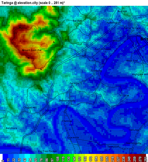
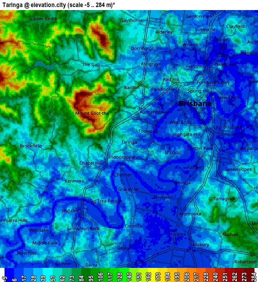
Below is the Elevation map of Taringa, which displays elevation range with different colors. Scale of the first map is from 0 to 281 m (0 to 922 ft) with average elevation of 50.6 meters (=166 ft) [note 1]
These maps also provides idea of topography and contour of this city, they are displayed at different zoom levels. More info about maps, scale and edge coordinates you can find below images.
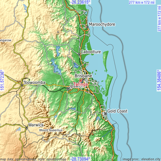
| \ | Map #1 | Map #2 | Topo.Map |
| Scale [m] | 0..281 m | -5..284 m | × |
| Scale [ft] | 0..922 ft | -16..932 ft | × |
| Average | 50.6 m = 166 ft | 49.5 m = 162 ft | × |
| Width | 8.67 km = 5.4 mi | 17.34 km = 10.8 mi | 277.4 km = 172.4 mi |
| Height | 8.67 km = 5.4 mi | 17.34 km = 10.8 mi | 277.4 km = 172.4 mi |
| ↑Max Latitude | -27.45162° | -27.412616° | -26.23615° |
| Latitude at center | -27.49061° | -27.49061° | -27.49061° |
| ↓Min Latitude | -27.529586° | -27.568549° | -28.73094° |
| ← Min Longitude | 152.934665° | 152.890719° | 151.57236° |
| Longitude center | 152.97861° | 152.97861° | 152.97861° |
| →Max Longitude | 153.022555° | 153.066501° | 154.38486° |
Nearby cities:
Cities around Taringa sort by population:
• Indooroopilly elevation 26 m
1.4 km,  193°
193°
• Toowong 41 m
0.9 km,  29°
29°
• Chapel Hill 49 m
3.1 km,  244°
244°
• West End 22 m
3.3 km,  67°
67°
• Bardon 58 m
3.3 km,  1°
1°
• South Brisbane 15 m
4.3 km, 74°
• Paddington 32 m
3.8 km, 25°
• Auchenflower 28 m
2.2 km,  36°
36°
• Highgate Hill 52 m
4 km,  87°
87°
• Graceville 16 m
3.5 km,  174°
174°
• Chelmer 12 m
2.5 km, 187°
• Milton 14 m
3.3 km,  47°
47°
Multilingual:
 En español:
Taringa elevación 36 m.
 En France:
Taringa élévation 36 m.


Sources and notes:
- [note 1] Map square and city borders are not equal. Map elevation data is calculated only from area inside that square.
- [src 1] Elevation data from geonames database provided with same terms of usage.
- [src 2] The elevation map of Taringa is generated using elevation data from NASA's 3 arcsec (90m) resolution SRTM data.
- [src 3] Base (background) map © OpenStreetMap contributors tiles are generated by Geofabrik and OpenTopoMap.
Copyright & License:
This Taringa Elevation Map is licensed under CC BY-SA. You may reuse any part from this page, if you give a proper credit by linking to this URL:
 More info on terms of use page.