Springfield Lakes elevation
Springfield Lakes (Queensland, Ipswich), Australia elevation is 73 meters and Springfield Lakes elevation in feet is 240 ft above sea level [src 1]. Springfield Lakes is a section of populated place (feature code) with elevation that is 40 meters (131 ft) smaller than average city elevation in Australia.
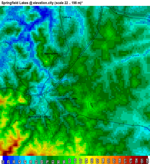
Below is the Elevation map of Springfield Lakes, which displays elevation range with different colors. Scale of the first map is from 22 to 198 m (72 to 650 ft) with average elevation of 75.1 meters (=246 ft) [note 1]
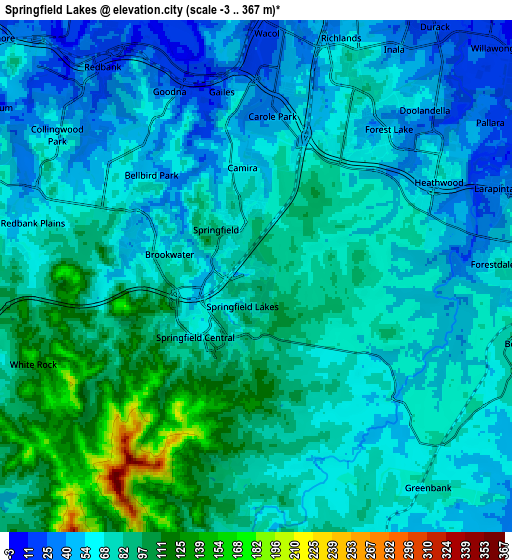
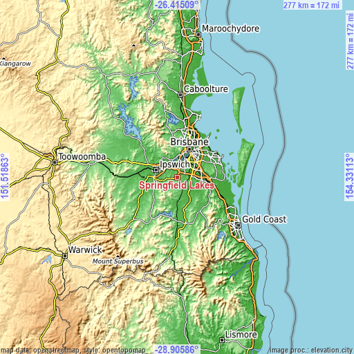
These maps also provides idea of topography and contour of this city, they are displayed at different zoom levels. More info about maps, scale and edge coordinates you can find below images.
| \ | Map #1 | Map #2 | Topo.Map |
| Scale [m] | 22..198 m | -3..367 m | × |
| Scale [ft] | 72..650 ft | -10..1204 ft | × |
| Average | 75.1 m = 246 ft | 72.4 m = 238 ft | × |
| Width | 8.66 km = 5.4 mi | 17.31 km = 10.8 mi | 276.9 km = 172.1 mi |
| Height | 8.66 km = 5.4 mi | 17.31 km = 10.8 mi | 277 km = 172.1 mi |
| ↑Max Latitude | -27.628643° | -27.589701° | -26.41509° |
| Latitude at center | -27.66757° | -27.66757° | -27.66757° |
| ↓Min Latitude | -27.706484° | -27.745383° | -28.90586° |
| ← Min Longitude | 152.880935° | 152.836989° | 151.51863° |
| Longitude center | 152.92488° | 152.92488° | 152.92488° |
| →Max Longitude | 152.968825° | 153.012771° | 154.33113° |
Nearby cities:
Cities around Springfield Lakes sort by population:
• Forest Lake elevation 57 m
6.4 km,  42°
42°
• Redbank Plains 57 m
6.9 km,  290°
290°
• Goodna 22 m
6.8 km,  338°
338°
• Camira 55 m
3.7 km,  353°
353°
• Springfield 69 m
1.7 km,  333°
333°
• Bellbird Park 47 m
5.1 km,  312°
312°
• Augustine Heights 45 m
4.6 km,  279°
279°
• Ellen Grove 49 m
6.1 km,  17°
17°
• Heathwood 63 m
7.2 km,  59°
59°
• Forestdale 56 m
7.8 km,  86°
86°
• Brookwater 81 m
2.9 km, 284°
• Gailes 26 m
6.4 km, 349°
Multilingual:
 En español:
Springfield Lakes elevación 73 m.
 En France:
Springfield Lakes élévation 73 m.
 Auf Deutsch:
Springfield Lakes höhe über dem Meeresspiegel ist 73 m.

Sources and notes:
- [note 1] Map square and city borders are not equal. Map elevation data is calculated only from area inside that square.
- [src 1] Elevation data from geonames database provided with same terms of usage.
- [src 2] The elevation map of Springfield Lakes is generated using elevation data from NASA's 3 arcsec (90m) resolution SRTM data.
- [src 3] Base (background) map © OpenStreetMap contributors tiles are generated by Geofabrik and OpenTopoMap.
Copyright & License:
This Springfield Lakes Elevation Map is licensed under CC BY-SA. You may reuse any part from this page, if you give a proper credit by linking to this URL:
 More info on terms of use page.