Figtree elevation
Figtree (New South Wales, Wollongong), Australia elevation is 46 meters and Figtree elevation in feet is 151 ft above sea level [src 1]. Figtree is a section of populated place (feature code) with elevation that is 67 meters (220 ft) smaller than average city elevation in Australia.
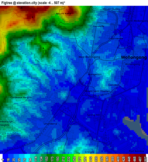
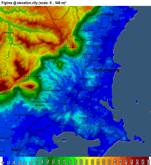
Below is the Elevation map of Figtree, which displays elevation range with different colors. Scale of the first map is from -4 to 507 m (-13 to 1663 ft) with average elevation of 75.6 meters (=248 ft) [note 1]
These maps also provides idea of topography and contour of this city, they are displayed at different zoom levels. More info about maps, scale and edge coordinates you can find below images.
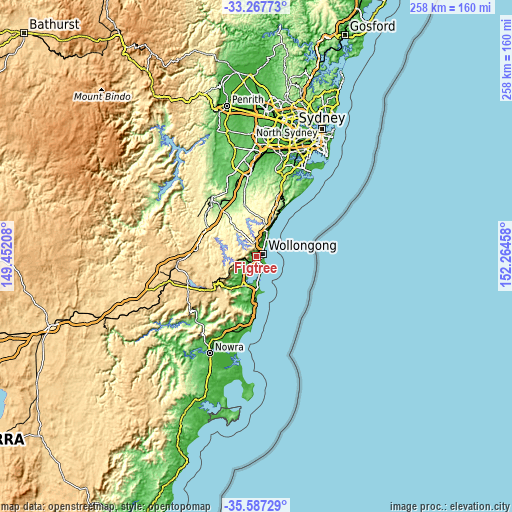
| \ | Map #1 | Map #2 | Topo.Map |
| Scale [m] | -4..507 m | -9..546 m | × |
| Scale [ft] | -13..1663 ft | -30..1791 ft | × |
| Average | 75.6 m = 248 ft | 148.3 m = 487 ft | × |
| Width | 8.06 km = 5 mi | 16.12 km = 10 mi | 257.9 km = 160.3 mi |
| Height | 8.06 km = 5 mi | 16.12 km = 10 mi | 257.9 km = 160.3 mi |
| ↑Max Latitude | -34.399308° | -34.36304° | -33.26773° |
| Latitude at center | -34.43556° | -34.43556° | -34.43556° |
| ↓Min Latitude | -34.471797° | -34.508017° | -35.58729° |
| ← Min Longitude | 150.814385° | 150.770439° | 149.45208° |
| Longitude center | 150.85833° | 150.85833° | 150.85833° |
| →Max Longitude | 150.902275° | 150.946221° | 152.26458° |
Nearby cities:
Cities around Figtree sort by population:
• Wollongong elevation 1 m
3.5 km,  68°
68°
• Wollongong city centre 10 m
3.3 km, 74°
• Unanderra 13 m
2.2 km,  207°
207°
• West Wollongong 36 m
1.3 km,  24°
24°
• Cordeaux Heights 31 m
2 km,  254°
254°
• Keiraville 58 m
2.2 km, 20°
• Gwynneville 9 m
3.4 km,  51°
51°
• Mangerton 37 m
1.2 km,  95°
95°
• Coniston 9 m
2.8 km,  125°
125°
• Cringila 5 m
4.1 km,  167°
167°
• Mount Saint Thomas 20 m
1.5 km,  124°
124°
• Mount Kembla 149 m
3.5 km,  282°
282°
Multilingual:
 En español:
Figtree elevación 46 m.
 En France:
Figtree élévation 46 m.


Sources and notes:
- [note 1] Map square and city borders are not equal. Map elevation data is calculated only from area inside that square.
- [src 1] Elevation data from geonames database provided with same terms of usage.
- [src 2] The elevation map of Figtree is generated using elevation data from NASA's 3 arcsec (90m) resolution SRTM data.
- [src 3] Base (background) map © OpenStreetMap contributors tiles are generated by Geofabrik and OpenTopoMap.
Copyright & License:
This Figtree Elevation Map is licensed under CC BY-SA. You may reuse any part from this page, if you give a proper credit by linking to this URL:
 More info on terms of use page.