Ashburton elevation
Ashburton (Victoria, Boroondara), Australia elevation is 68 meters and Ashburton elevation in feet is 223 ft above sea level [src 1]. Ashburton is a section of populated place (feature code) with elevation that is 45 meters (148 ft) smaller than average city elevation in Australia.
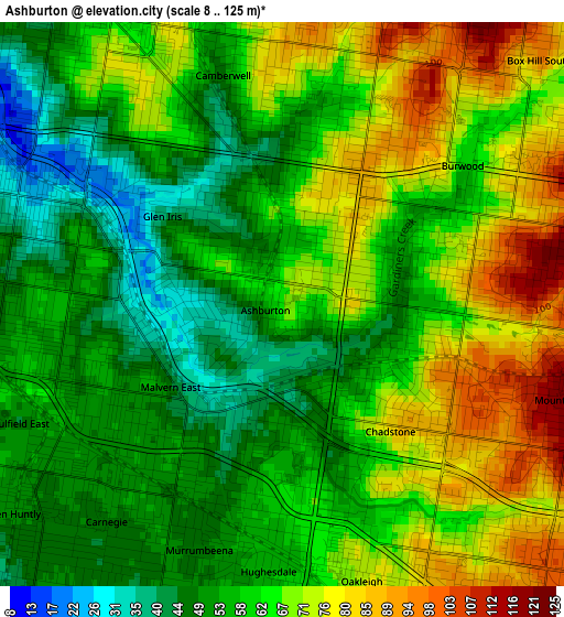
Below is the Elevation map of Ashburton, which displays elevation range with different colors. Scale of the first map is from 8 to 125 m (26 to 410 ft) with average elevation of 61.7 meters (=202 ft) [note 1]
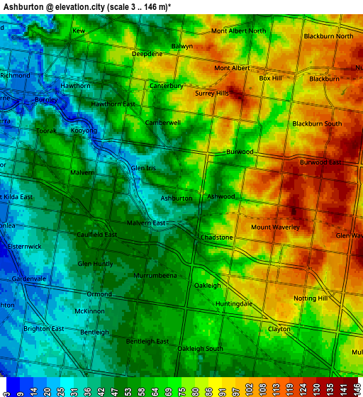
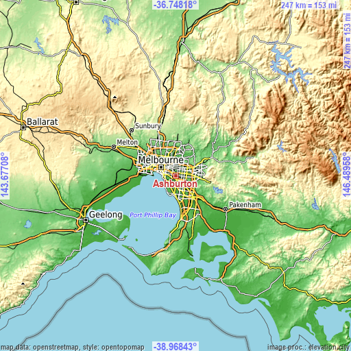
These maps also provides idea of topography and contour of this city, they are displayed at different zoom levels. More info about maps, scale and edge coordinates you can find below images.
| \ | Map #1 | Map #2 | Topo.Map |
| Scale [m] | 8..125 m | 3..146 m | × |
| Scale [ft] | 26..410 ft | 10..479 ft | × |
| Average | 61.7 m = 202 ft | 66.1 m = 217 ft | × |
| Width | 7.71 km = 4.8 mi | 15.43 km = 9.6 mi | 246.9 km = 153.4 mi |
| Height | 7.71 km = 4.8 mi | 15.43 km = 9.6 mi | 246.9 km = 153.4 mi |
| ↑Max Latitude | -37.83197° | -37.797253° | -36.74818° |
| Latitude at center | -37.86667° | -37.86667° | -37.86667° |
| ↓Min Latitude | -37.901354° | -37.936022° | -38.96843° |
| ← Min Longitude | 145.039385° | 144.995439° | 143.67708° |
| Longitude center | 145.08333° | 145.08333° | 145.08333° |
| →Max Longitude | 145.127275° | 145.171221° | 146.48958° |
Nearby cities:
Cities around Ashburton sort by population:
• Mount Waverley elevation 121 m
4.2 km,  105°
105°
• Glen Iris 30 m
1.5 km,  270°
270°
• Camberwell 47 m
3 km,  335°
335°
• Malvern East 60 m
3.7 km,  257°
257°
• Carnegie 53 m
3.9 km,  219°
219°
• Burwood 80 m
3.7 km,  59°
59°
• Murrumbeena 49 m
4 km,  201°
201°
• Chadstone 60 m
2.6 km,  155°
155°
• Oakleigh 65 m
3.5 km,  172°
172°
• Hughesdale 59 m
3.7 km,  180°
180°
• Ashwood 56 m
1.9 km,  89°
89°
• Caulfield East 51 m
4 km,  245°
245°
Multilingual:
 En español:
Ashburton elevación 68 m.
 En France:
Ashburton élévation 68 m.
 Auf Deutsch:
Ashburton höhe über dem Meeresspiegel ist 68 m.

Sources and notes:
- [note 1] Map square and city borders are not equal. Map elevation data is calculated only from area inside that square.
- [src 1] Elevation data from geonames database provided with same terms of usage.
- [src 2] The elevation map of Ashburton is generated using elevation data from NASA's 3 arcsec (90m) resolution SRTM data.
- [src 3] Base (background) map © OpenStreetMap contributors tiles are generated by Geofabrik and OpenTopoMap.
Copyright & License:
This Ashburton Elevation Map is licensed under CC BY-SA. You may reuse any part from this page, if you give a proper credit by linking to this URL:
 More info on terms of use page.