Bargo elevation
Bargo (New South Wales, Wollondilly), Australia elevation is 340 meters and Bargo elevation in feet is 1115 ft above sea level [src 1]. Bargo is a populated place (feature code) with elevation that is 227 meters (745 ft) bigger than average city elevation in Australia.
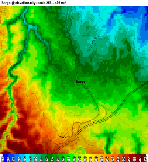
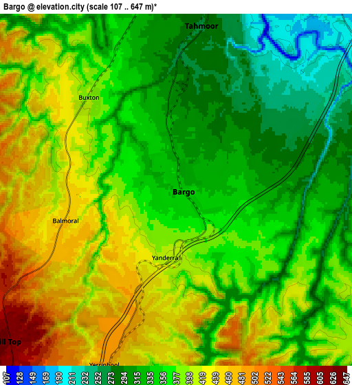
Below is the Elevation map of Bargo, which displays elevation range with different colors. Scale of the first map is from 256 to 476 m (840 to 1562 ft) with average elevation of 359.9 meters (=1181 ft) [note 1]
These maps also provides idea of topography and contour of this city, they are displayed at different zoom levels. More info about maps, scale and edge coordinates you can find below images.
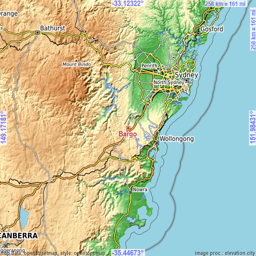
| \ | Map #1 | Map #2 | Topo.Map |
| Scale [m] | 256..476 m | 107..647 m | × |
| Scale [ft] | 840..1562 ft | 351..2123 ft | × |
| Average | 359.9 m = 1181 ft | 372.7 m = 1223 ft | × |
| Width | 8.07 km = 5 mi | 16.15 km = 10 mi | 258.4 km = 160.6 mi |
| Height | 8.07 km = 5 mi | 16.15 km = 10 mi | 258.4 km = 160.6 mi |
| ↑Max Latitude | -34.256696° | -34.220366° | -33.12322° |
| Latitude at center | -34.29301° | -34.29301° | -34.29301° |
| ↓Min Latitude | -34.329308° | -34.365591° | -35.44673° |
| ← Min Longitude | 150.534115° | 150.490169° | 149.17181° |
| Longitude center | 150.57806° | 150.57806° | 150.57806° |
| →Max Longitude | 150.622005° | 150.665951° | 151.98431° |
Nearby cities:
Cities around Bargo sort by population:
• Mittagong elevation 635 m
21.3 km,  214°
214°
• Tahmoor 280 m
8 km,  11°
11°
• Picton 161 m
14 km, 12°
• Thirlmere 298 m
9.9 km,  354°
354°
• Wilton 224 m
12.4 km,  62°
62°
• Hill Top 620 m
9.7 km,  231°
231°
• Appin 242 m
21.6 km, 62°
• Buxton 404 m
5.5 km,  311°
311°
• Colo Vale 647 m
14.7 km,  215°
215°
• Douglas Park 119 m
17.4 km,  46°
46°
• Yerrinbool 477 m
9.2 km,  203°
203°
• Razorback 278 m
17.1 km,  23°
23°
Multilingual:
 En español:
Bargo elevación 340 m.
 En France:
Bargo élévation 340 m.


Sources and notes:
- [note 1] Map square and city borders are not equal. Map elevation data is calculated only from area inside that square.
- [src 1] Elevation data from geonames database provided with same terms of usage.
- [src 2] The elevation map of Bargo is generated using elevation data from NASA's 3 arcsec (90m) resolution SRTM data.
- [src 3] Base (background) map © OpenStreetMap contributors tiles are generated by Geofabrik and OpenTopoMap.
Copyright & License:
This Bargo Elevation Map is licensed under CC BY-SA. You may reuse any part from this page, if you give a proper credit by linking to this URL:
 More info on terms of use page.