Blaxland elevation
Blaxland (New South Wales, Blue Mountains Municipality), Australia elevation is 120 meters and Blaxland elevation in feet is 394 ft above sea level [src 1]. Blaxland is a populated place (feature code) with elevation that is 7 meters (23 ft) bigger than average city elevation in Australia.
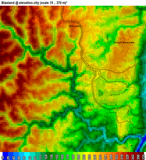
Below is the Elevation map of Blaxland, which displays elevation range with different colors. Scale of the first map is from 15 to 370 m (49 to 1214 ft) with average elevation of 227.8 meters (=747 ft) [note 1]
These maps also provides idea of topography and contour of this city, they are displayed at different zoom levels. More info about maps, scale and edge coordinates you can find below images.
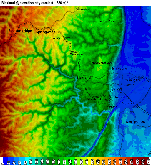
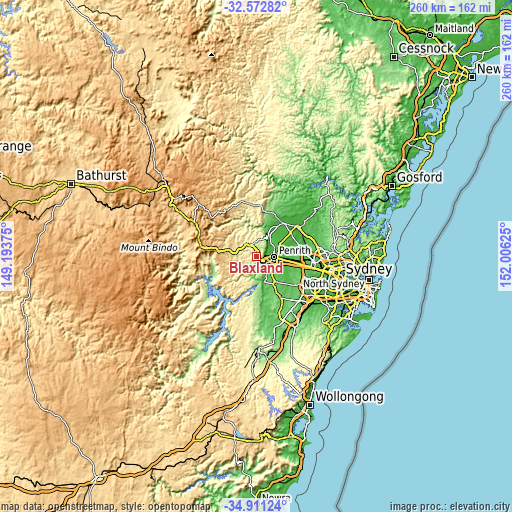
| \ | Map #1 | Map #2 | Topo.Map |
| Scale [m] | 15..370 m | 0..536 m | × |
| Scale [ft] | 49..1214 ft | 0..1759 ft | × |
| Average | 227.8 m = 747 ft | 224.6 m = 737 ft | × |
| Width | 8.13 km = 5.1 mi | 16.25 km = 10.1 mi | 260 km = 161.6 mi |
| Height | 8.13 km = 5.1 mi | 16.25 km = 10.1 mi | 260 km = 161.6 mi |
| ↑Max Latitude | -33.713453° | -33.67689° | -32.57282° |
| Latitude at center | -33.75° | -33.75° | -33.75° |
| ↓Min Latitude | -33.786531° | -33.823047° | -34.91124° |
| ← Min Longitude | 150.556055° | 150.512109° | 149.19375° |
| Longitude center | 150.6° | 150.6° | 150.6° |
| →Max Longitude | 150.643945° | 150.687891° | 152.00625° |
Nearby cities:
Cities around Blaxland sort by population:
• Glenmore Park elevation 48 m
7.8 km,  125°
125°
• Emu Plains 27 m
6.2 km,  90°
90°
• Springwood 357 m
7.2 km,  320°
320°
• Winmalee 272 m
8 km,  8°
8°
• Jamisontown 31 m
7.4 km,  105°
105°
• Glenbrook 187 m
2.4 km,  140°
140°
• Faulconbridge 441 m
8.3 km,  312°
312°
• Emu Heights 46 m
4.8 km,  69°
69°
• Mount Riverview 244 m
3.9 km,  56°
56°
• Leonay 47 m
4.8 km, 111°
• Warrimoo 231 m
3.7 km,  0°
0°
• Valley Heights 323 m
5.8 km,  344°
344°
Multilingual:
 En español:
Blaxland elevación 120 m.
 En France:
Blaxland élévation 120 m.
 Auf Deutsch:
Blaxland höhe über dem Meeresspiegel ist 120 m.

Sources and notes:
- [note 1] Map square and city borders are not equal. Map elevation data is calculated only from area inside that square.
- [src 1] Elevation data from geonames database provided with same terms of usage.
- [src 2] The elevation map of Blaxland is generated using elevation data from NASA's 3 arcsec (90m) resolution SRTM data.
- [src 3] Base (background) map © OpenStreetMap contributors tiles are generated by Geofabrik and OpenTopoMap.
Copyright & License:
This Blaxland Elevation Map is licensed under CC BY-SA. You may reuse any part from this page, if you give a proper credit by linking to this URL:
 More info on terms of use page.