Boyne Island elevation
Boyne Island (Queensland, Gladstone), Australia elevation is 22 meters and Boyne Island elevation in feet is 72 ft above sea level [src 1]. Boyne Island is a populated place (feature code) with elevation that is 91 meters (299 ft) smaller than average city elevation in Australia.
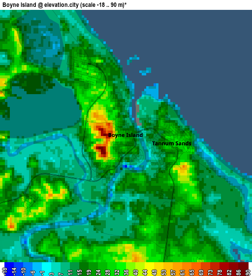
Below is the Elevation map of Boyne Island, which displays elevation range with different colors. Scale of the first map is from -18 to 90 m (-59 to 295 ft) with average elevation of 17.3 meters (=57 ft) [note 1]
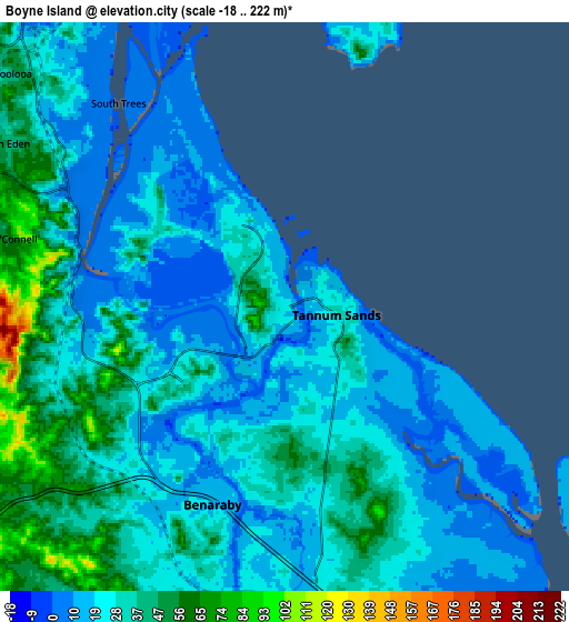
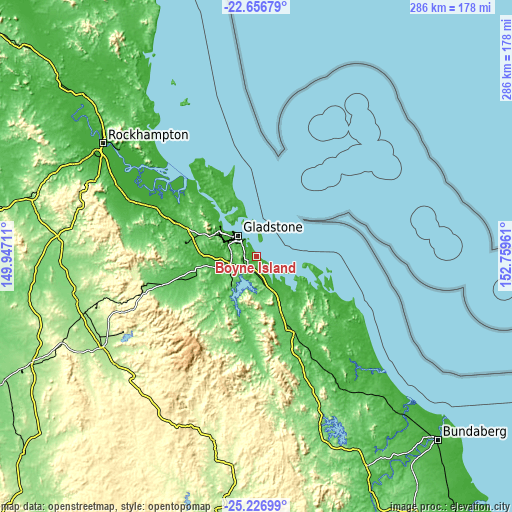
These maps also provides idea of topography and contour of this city, they are displayed at different zoom levels. More info about maps, scale and edge coordinates you can find below images.
| \ | Map #1 | Map #2 | Topo.Map |
| Scale [m] | -18..90 m | -18..222 m | × |
| Scale [ft] | -59..295 ft | -59..728 ft | × |
| Average | 17.3 m = 57 ft | 28.2 m = 93 ft | × |
| Width | 8.93 km = 5.5 mi | 17.86 km = 11.1 mi | 285.8 km = 177.6 mi |
| Height | 8.93 km = 5.5 mi | 17.86 km = 11.1 mi | 285.8 km = 177.6 mi |
| ↑Max Latitude | -23.908122° | -23.867941° | -22.65679° |
| Latitude at center | -23.94829° | -23.94829° | -23.94829° |
| ↓Min Latitude | -23.988446° | -24.028589° | -25.22699° |
| ← Min Longitude | 151.309415° | 151.265469° | 149.94711° |
| Longitude center | 151.35336° | 151.35336° | 151.35336° |
| →Max Longitude | 151.397305° | 151.441251° | 152.75961° |
Nearby cities:
Cities around Boyne Island sort by population:
• Gladstone elevation 21 m
14.7 km,  318°
318°
• Tannum Sands 23 m
1.4 km,  86°
86°
• New Auckland 27 m
14 km,  301°
301°
• West Gladstone 15 m
14.6 km,  311°
311°
• South Gladstone 22 m
12.9 km, 317°
• Glen Eden 40 m
10.1 km, 304°
• Kin Kora 33 m
13.4 km, 306°
• Kirkwood 69 m
13 km,  292°
292°
• Telina 43 m
12.1 km, 303°
• Benaraby 14 m
6.5 km,  197°
197°
• Sun Valley 51 m
12.7 km, 309°
• Barney Point 7 m
14.3 km, 321°
Multilingual:
 En español:
Boyne Island elevación 22 m.
 En France:
Boyne Island élévation 22 m.
 Auf Deutsch:
Boyne Island höhe über dem Meeresspiegel ist 22 m.

Sources and notes:
- [note 1] Map square and city borders are not equal. Map elevation data is calculated only from area inside that square.
- [src 1] Elevation data from geonames database provided with same terms of usage.
- [src 2] The elevation map of Boyne Island is generated using elevation data from NASA's 3 arcsec (90m) resolution SRTM data.
- [src 3] Base (background) map © OpenStreetMap contributors tiles are generated by Geofabrik and OpenTopoMap.
Copyright & License:
This Boyne Island Elevation Map is licensed under CC BY-SA. You may reuse any part from this page, if you give a proper credit by linking to this URL:
 More info on terms of use page.