Brookfield elevation
Brookfield (Queensland, Brisbane), Australia elevation is 114 meters and Brookfield elevation in feet is 374 ft above sea level [src 1]. Brookfield is a section of populated place (feature code) with elevation that is 1 meters (3 ft) bigger than average city elevation in Australia.
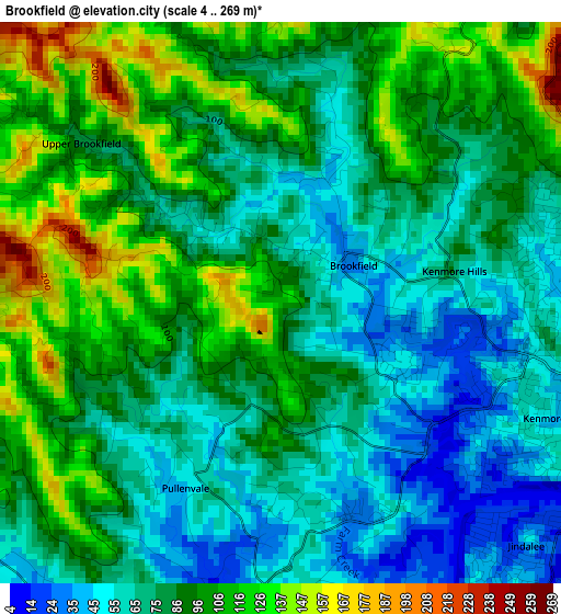
Below is the Elevation map of Brookfield, which displays elevation range with different colors. Scale of the first map is from 4 to 269 m (13 to 883 ft) with average elevation of 85.8 meters (=281 ft) [note 1]
These maps also provides idea of topography and contour of this city, they are displayed at different zoom levels. More info about maps, scale and edge coordinates you can find below images.
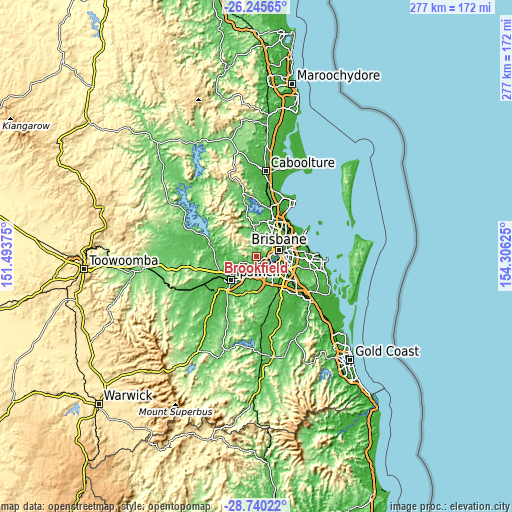
| \ | Map #1 | Topo.Map |
| Scale [m] | 4..269 m | × |
| Scale [ft] | 13..883 ft | × |
| Average | 85.8 m = 281 ft | × |
| Width | 8.67 km = 5.4 mi | 277.4 km = 172.4 mi |
| Height | 8.67 km = 5.4 mi | 277.4 km = 172.4 mi |
| ↑Max Latitude | -27.461013° | -26.24565° |
| Latitude at center | -27.5° | -27.5° |
| ↓Min Latitude | -27.538973° | -28.74022° |
| ← Min Longitude | 152.856055° | 151.49375° |
| Longitude center | 152.9° | 152.9° |
| →Max Longitude | 152.943945° | 154.30625° |
Nearby cities:
Cities around Brookfield sort by population:
• Chapel Hill elevation 49 m
5 km,  93°
93°
• Kenmore 47 m
3.9 km,  102°
102°
• Bellbowrie 41 m
6.8 km,  194°
194°
• Jindalee 43 m
5.4 km,  135°
135°
• Westlake 17 m
5.6 km,  166°
166°
• Riverhills 17 m
6.7 km, 170°
• Fig Tree Pocket 33 m
6.8 km,  116°
116°
• Middle Park 22 m
6.6 km,  160°
160°
• Pullenvale 57 m
2.9 km,  207°
207°
• Mount Ommaney 27 m
6 km,  148°
148°
• Kenmore Hills 29 m
3.2 km, 98°
• Anstead 41 m
5.6 km,  221°
221°
Multilingual:
 En español:
Brookfield elevación 114 m.
 En France:
Brookfield élévation 114 m.
 Auf Deutsch:
Brookfield höhe über dem Meeresspiegel ist 114 m.

Sources and notes:
- [note 1] Map square and city borders are not equal. Map elevation data is calculated only from area inside that square.
- [src 1] Elevation data from geonames database provided with same terms of usage.
- [src 2] The elevation map of Brookfield is generated using elevation data from NASA's 3 arcsec (90m) resolution SRTM data.
- [src 3] Base (background) map © OpenStreetMap contributors tiles are generated by Geofabrik and OpenTopoMap.
Copyright & License:
This Brookfield Elevation Map is licensed under CC BY-SA. You may reuse any part from this page, if you give a proper credit by linking to this URL:
 More info on terms of use page.