Coonabarabran elevation
Coonabarabran (New South Wales, Warrumbungle Shire), Australia elevation is 518 meters and Coonabarabran elevation in feet is 1699 ft above sea level [src 1]. Coonabarabran is a populated place (feature code) with elevation that is 405 meters (1329 ft) bigger than average city elevation in Australia.
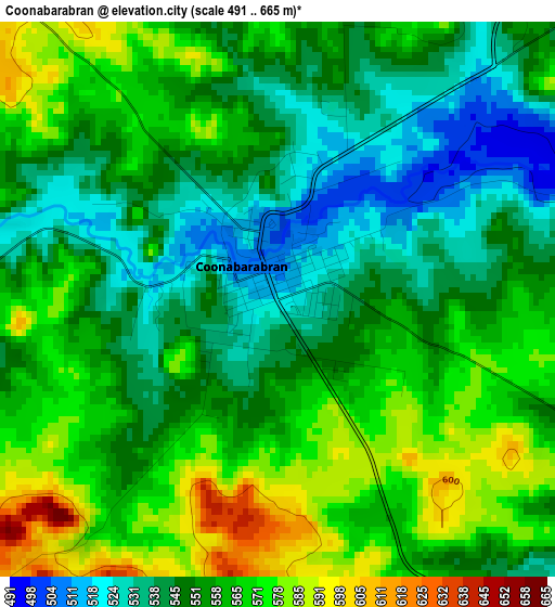
Below is the Elevation map of Coonabarabran, which displays elevation range with different colors. Scale of the first map is from 491 to 665 m (1611 to 2182 ft) with average elevation of 555.4 meters (=1822 ft) [note 1]
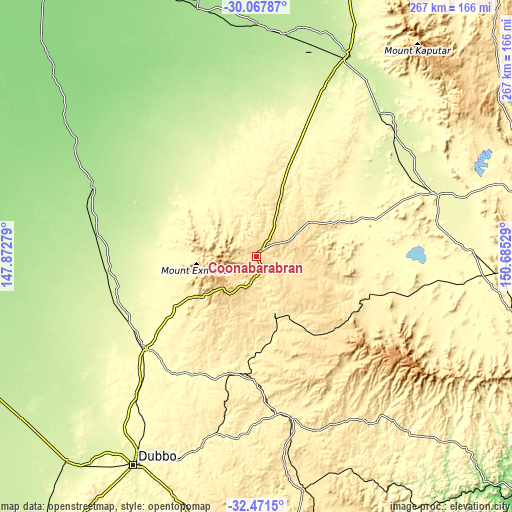
These maps also provides idea of topography and contour of this city, they are displayed at different zoom levels. More info about maps, scale and edge coordinates you can find below images.
| \ | Map #1 | Topo.Map |
| Scale [m] | 491..665 m | × |
| Scale [ft] | 1611..2182 ft | × |
| Average | 555.4 m = 1822 ft | × |
| Width | 8.35 km = 5.2 mi | 267.3 km = 166.1 mi |
| Height | 8.35 km = 5.2 mi | 267.3 km = 166.1 mi |
| ↑Max Latitude | -31.239774° | -30.06787° |
| Latitude at center | -31.27734° | -31.27734° |
| ↓Min Latitude | -31.314891° | -32.4715° |
| ← Min Longitude | 149.235095° | 147.87279° |
| Longitude center | 149.27904° | 149.27904° |
| →Max Longitude | 149.322985° | 150.68529° |
Nearby cities:
Cities around Coonabarabran sort by population:
• Dubbo elevation 264 m
124.9 km,  210°
210°
• Gunnedah 273 m
98.9 km,  70°
70°
• Narrabri 214 m
116.3 km,  24°
24°
• Gilgandra 287 m
75.8 km,  230°
230°
• Coonamble 182 m
92.1 km,  292°
292°
• Blair Athol 281 m
112.1 km,  51°
51°
• Gulgong 471 m
123 km,  168°
168°
• Wee Waa 194 m
117.8 km,  7°
7°
• Eulomogo 319 m
123.6 km, 207°
• Boggabri 256 m
96.2 km, 49°
• Dunedoo 384 m
82.8 km, 172°
• Coolah 492 m
73.9 km,  145°
145°
Multilingual:
 En español:
Coonabarabran elevación 518 m.
 En France:
Coonabarabran élévation 518 m.
 Auf Deutsch:
Coonabarabran höhe über dem Meeresspiegel ist 518 m.

Sources and notes:
- [note 1] Map square and city borders are not equal. Map elevation data is calculated only from area inside that square.
- [src 1] Elevation data from geonames database provided with same terms of usage.
- [src 2] The elevation map of Coonabarabran is generated using elevation data from NASA's 3 arcsec (90m) resolution SRTM data.
- [src 3] Base (background) map © OpenStreetMap contributors tiles are generated by Geofabrik and OpenTopoMap.
Copyright & License:
This Coonabarabran Elevation Map is licensed under CC BY-SA. You may reuse any part from this page, if you give a proper credit by linking to this URL:
 More info on terms of use page.