Doreen elevation
Doreen (Victoria, Nillumbik), Australia elevation is 159 meters and Doreen elevation in feet is 522 ft above sea level [src 1]. Doreen is a section of populated place (feature code) with elevation that is 46 meters (151 ft) bigger than average city elevation in Australia.
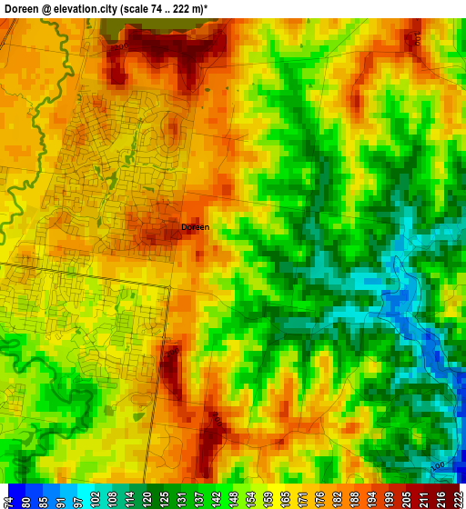
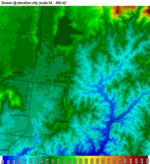
Below is the Elevation map of Doreen, which displays elevation range with different colors. Scale of the first map is from 74 to 222 m (243 to 728 ft) with average elevation of 157.5 meters (=517 ft) [note 1]
These maps also provides idea of topography and contour of this city, they are displayed at different zoom levels. More info about maps, scale and edge coordinates you can find below images.
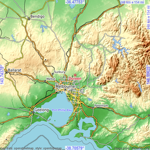
| \ | Map #1 | Map #2 | Topo.Map |
| Scale [m] | 74..222 m | 54..450 m | × |
| Scale [ft] | 243..728 ft | 177..1476 ft | × |
| Average | 157.5 m = 517 ft | 164.6 m = 540 ft | × |
| Width | 7.74 km = 4.8 mi | 15.49 km = 9.6 mi | 247.8 km = 154 mi |
| Height | 7.74 km = 4.8 mi | 15.49 km = 9.6 mi | 247.8 km = 154 mi |
| ↑Max Latitude | -37.565174° | -37.530333° | -36.47753° |
| Latitude at center | -37.6° | -37.6° | -37.6° |
| ↓Min Latitude | -37.634809° | -37.669602° | -38.70579° |
| ← Min Longitude | 145.106055° | 145.062109° | 143.74375° |
| Longitude center | 145.15° | 145.15° | 145.15° |
| →Max Longitude | 145.193945° | 145.237891° | 146.55625° |
Nearby cities:
Cities around Doreen sort by population:
• Mill Park elevation 133 m
10.4 km,  224°
224°
• South Morang 145 m
7.1 km, 218°
• Mernda 167 m
4.8 km,  269°
269°
• Diamond Creek 91 m
7.4 km,  180°
180°
• Wollert 199 m
10.4 km,  280°
280°
• Whittlesea 198 m
10.2 km,  344°
344°
• Hurstbridge 109 m
6 km,  139°
139°
• St Helena 99 m
10.3 km,  193°
193°
• Plenty 135 m
8 km,  201°
201°
• Wattleglen 68 m
8 km,  158°
158°
• Yarrambat 177 m
4.4 km, 197°
• Panton Hill 201 m
9.1 km,  119°
119°
Multilingual:
 En español:
Doreen elevación 159 m.
 En France:
Doreen élévation 159 m.


Sources and notes:
- [note 1] Map square and city borders are not equal. Map elevation data is calculated only from area inside that square.
- [src 1] Elevation data from geonames database provided with same terms of usage.
- [src 2] The elevation map of Doreen is generated using elevation data from NASA's 3 arcsec (90m) resolution SRTM data.
- [src 3] Base (background) map © OpenStreetMap contributors tiles are generated by Geofabrik and OpenTopoMap.
Copyright & License:
This Doreen Elevation Map is licensed under CC BY-SA. You may reuse any part from this page, if you give a proper credit by linking to this URL:
 More info on terms of use page.