Guyra elevation
Guyra (New South Wales, Armidale Regional), Australia elevation is 1326 meters and Guyra elevation in feet is 4350 ft above sea level [src 1]. Guyra is a populated place (feature code) with elevation that is 1213 meters (3980 ft) bigger than average city elevation in Australia.
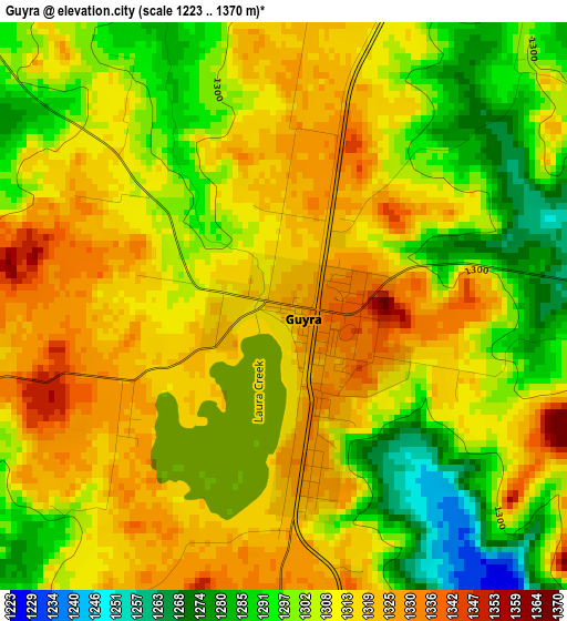
Below is the Elevation map of Guyra, which displays elevation range with different colors. Scale of the first map is from 1223 to 1370 m (4012 to 4495 ft) with average elevation of 1308.7 meters (=4294 ft) [note 1]
These maps also provides idea of topography and contour of this city, they are displayed at different zoom levels. More info about maps, scale and edge coordinates you can find below images.
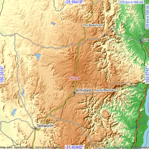
| \ | Map #1 | Topo.Map |
| Scale [m] | 1223..1370 m | × |
| Scale [ft] | 4012..4495 ft | × |
| Average | 1308.7 m = 4294 ft | × |
| Width | 8.44 km = 5.2 mi | 270.2 km = 167.9 mi |
| Height | 8.44 km = 5.2 mi | 270.2 km = 167.9 mi |
| ↑Max Latitude | -30.178818° | -28.99418° |
| Latitude at center | -30.2168° | -30.2168° |
| ↓Min Latitude | -30.254767° | -31.42442° |
| ← Min Longitude | 151.623905° | 150.2616° |
| Longitude center | 151.66785° | 151.66785° |
| →Max Longitude | 151.711795° | 153.0741° |
Nearby cities:
Cities around Guyra sort by population:
• Armidale elevation 1053 m
31.6 km,  180°
180°
• Inverell 588 m
72.7 km,  312°
312°
• Glen Innes 1071 m
54 km,  7°
7°
• East Tamworth 419 m
119.2 km,  215°
215°
• Uralla 1005 m
49.8 km,  198°
198°
• Walcha 1047 m
85.7 km, 184°
• Manilla 358 m
108.3 km,  236°
236°
• Kootingal 425 m
110.5 km,  212°
212°
• Bingara 302 m
112.3 km,  290°
290°
• Barraba 493 m
103.4 km,  259°
259°
• Dorrigo 756 m
101.4 km,  97°
97°
• Moonbi 465 m
105.8 km, 212°
Multilingual:
 En español:
Guyra elevación 1326 m.
 En France:
Guyra élévation 1326 m.


Sources and notes:
- [note 1] Map square and city borders are not equal. Map elevation data is calculated only from area inside that square.
- [src 1] Elevation data from geonames database provided with same terms of usage.
- [src 2] The elevation map of Guyra is generated using elevation data from NASA's 3 arcsec (90m) resolution SRTM data.
- [src 3] Base (background) map © OpenStreetMap contributors tiles are generated by Geofabrik and OpenTopoMap.
Copyright & License:
This Guyra Elevation Map is licensed under CC BY-SA. You may reuse any part from this page, if you give a proper credit by linking to this URL:
 More info on terms of use page.