Leichhardt elevation
Leichhardt (New South Wales, Inner West), Australia elevation is 44 meters and Leichhardt elevation in feet is 144 ft above sea level [src 1]. Leichhardt is a section of populated place (feature code) with elevation that is 69 meters (226 ft) smaller than average city elevation in Australia.
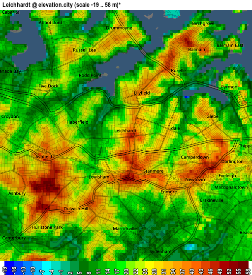
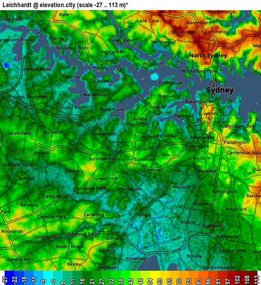
Below is the Elevation map of Leichhardt, which displays elevation range with different colors. Scale of the first map is from -19 to 58 m (-62 to 190 ft) with average elevation of 20.8 meters (=68 ft) [note 1]
These maps also provides idea of topography and contour of this city, they are displayed at different zoom levels. More info about maps, scale and edge coordinates you can find below images.
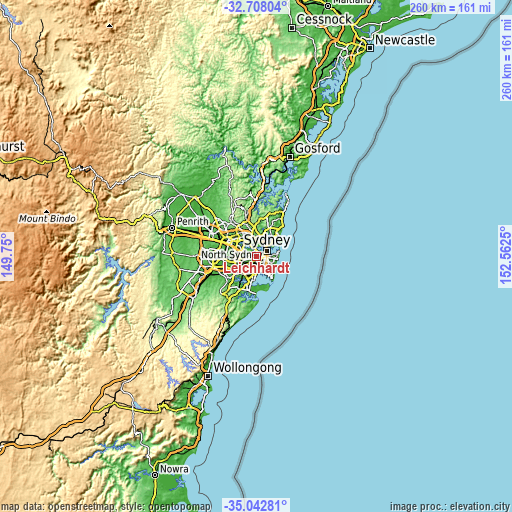
| \ | Map #1 | Map #2 | Topo.Map |
| Scale [m] | -19..58 m | -27..113 m | × |
| Scale [ft] | -62..190 ft | -89..371 ft | × |
| Average | 20.8 m = 68 ft | 28.1 m = 92 ft | × |
| Width | 8.11 km = 5 mi | 16.23 km = 10.1 mi | 259.6 km = 161.3 mi |
| Height | 8.11 km = 5 mi | 16.23 km = 10.1 mi | 259.6 km = 161.3 mi |
| ↑Max Latitude | -33.84692° | -33.810414° | -32.70804° |
| Latitude at center | -33.88341° | -33.88341° | -33.88341° |
| ↓Min Latitude | -33.919884° | -33.956343° | -35.04281° |
| ← Min Longitude | 151.112305° | 151.068359° | 149.75° |
| Longitude center | 151.15625° | 151.15625° | 151.15625° |
| →Max Longitude | 151.200195° | 151.244141° | 152.5625° |
Nearby cities:
Cities around Leichhardt sort by population:
• Glebe elevation 29 m
2.6 km,  78°
78°
• Camperdown 24 m
2 km,  110°
110°
• Annandale 20 m
1 km,  89°
89°
• Petersham 42 m
1.2 km,  185°
185°
• Stanmore 30 m
1.4 km,  148°
148°
• Lilyfield 20 m
1.3 km,  41°
41°
• Summer Hill 20 m
1.9 km,  241°
241°
• Haberfield 6 m
1.1 km,  272°
272°
• Forest Lodge 28 m
2.2 km, 84°
• Enmore 1 m
2.5 km,  140°
140°
• Lewisham 33 m
1.7 km,  204°
204°
• Rodd Point 13 m
2.4 km,  321°
321°
Multilingual:
 En español:
Leichhardt elevación 44 m.
 En France:
Leichhardt élévation 44 m.
 Auf Deutsch:
Leichhardt höhe über dem Meeresspiegel ist 44 m.

Sources and notes:
- [note 1] Map square and city borders are not equal. Map elevation data is calculated only from area inside that square.
- [src 1] Elevation data from geonames database provided with same terms of usage.
- [src 2] The elevation map of Leichhardt is generated using elevation data from NASA's 3 arcsec (90m) resolution SRTM data.
- [src 3] Base (background) map © OpenStreetMap contributors tiles are generated by Geofabrik and OpenTopoMap.
Copyright & License:
This Leichhardt Elevation Map is licensed under CC BY-SA. You may reuse any part from this page, if you give a proper credit by linking to this URL:
 More info on terms of use page.