Maldon elevation
Maldon (Victoria, Mount Alexander), Australia elevation is 360 meters and Maldon elevation in feet is 1181 ft above sea level [src 1]. Maldon is a populated place (feature code) with elevation that is 247 meters (810 ft) bigger than average city elevation in Australia.
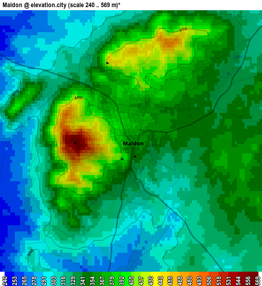
Below is the Elevation map of Maldon, which displays elevation range with different colors. Scale of the first map is from 240 to 569 m (787 to 1867 ft) with average elevation of 338.2 meters (=1110 ft) [note 1]
These maps also provides idea of topography and contour of this city, they are displayed at different zoom levels. More info about maps, scale and edge coordinates you can find below images.
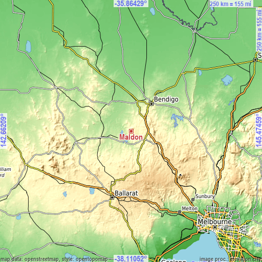
| \ | Map #1 | Topo.Map |
| Scale [m] | 240..569 m | × |
| Scale [ft] | 787..1867 ft | × |
| Average | 338.2 m = 1110 ft | × |
| Width | 7.81 km = 4.9 mi | 249.8 km = 155.2 mi |
| Height | 7.81 km = 4.9 mi | 249.8 km = 155.2 mi |
| ↑Max Latitude | -36.960594° | -35.86429° |
| Latitude at center | -36.9957° | -36.9957° |
| ↓Min Latitude | -37.03079° | -38.11052° |
| ← Min Longitude | 144.024395° | 142.66209° |
| Longitude center | 144.06834° | 144.06834° |
| →Max Longitude | 144.112285° | 145.47459° |
Nearby cities:
Cities around Maldon sort by population:
• Kangaroo Flat elevation 262 m
27.1 km,  36°
36°
• Golden Square 235 m
29.7 km,  33°
33°
• Maryborough 241 m
29.7 km,  259°
259°
• Castlemaine 281 m
15.4 km,  121°
121°
• Maiden Gully 225 m
29.6 km,  24°
24°
• Flora Hill 272 m
31.3 km, 40°
• Quarry Hill 262 m
30.8 km, 37°
• Campbells Creek 269 m
15.6 km,  130°
130°
• Marong 193 m
29.7 km,  11°
11°
• Chewton 320 m
19.3 km, 119°
• Carisbrook 197 m
23.1 km, 255°
• Ironbark 253 m
31.9 km, 32°
Multilingual:
 En español:
Maldon elevación 360 m.
 En France:
Maldon élévation 360 m.


Sources and notes:
- [note 1] Map square and city borders are not equal. Map elevation data is calculated only from area inside that square.
- [src 1] Elevation data from geonames database provided with same terms of usage.
- [src 2] The elevation map of Maldon is generated using elevation data from NASA's 3 arcsec (90m) resolution SRTM data.
- [src 3] Base (background) map © OpenStreetMap contributors tiles are generated by Geofabrik and OpenTopoMap.
Copyright & License:
This Maldon Elevation Map is licensed under CC BY-SA. You may reuse any part from this page, if you give a proper credit by linking to this URL:
 More info on terms of use page.