Morayfield elevation
Morayfield (Queensland, Moreton Bay), Australia elevation is 8 meters and Morayfield elevation in feet is 26 ft above sea level [src 1]. Morayfield is a section of populated place (feature code) with elevation that is 105 meters (344 ft) smaller than average city elevation in Australia.
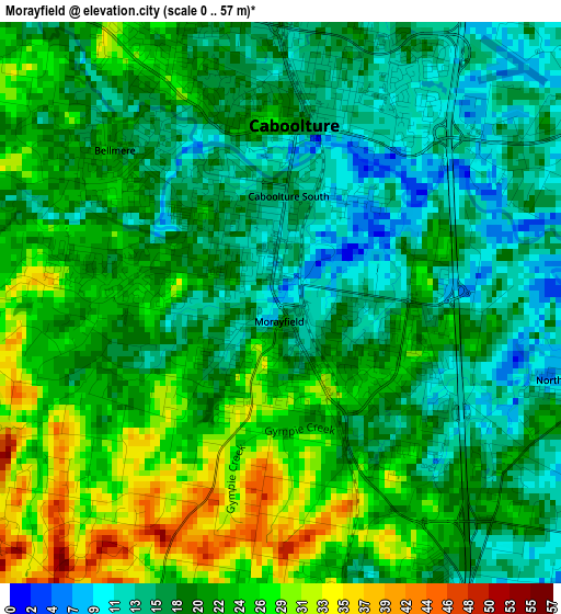
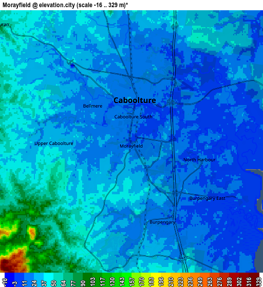
Below is the Elevation map of Morayfield, which displays elevation range with different colors. Scale of the first map is from 0 to 57 m (0 to 187 ft) with average elevation of 20.2 meters (=66 ft) [note 1]
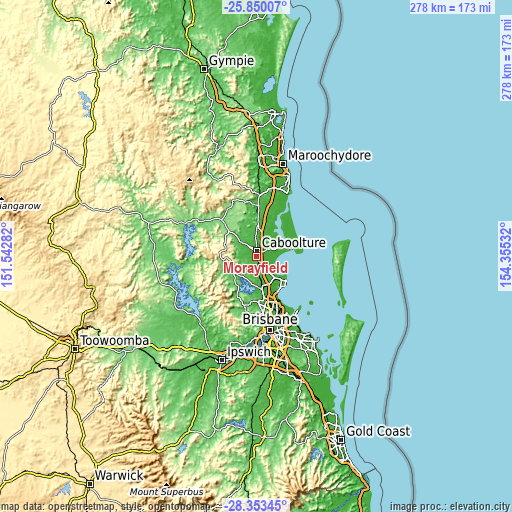
These maps also provides idea of topography and contour of this city, they are displayed at different zoom levels. More info about maps, scale and edge coordinates you can find below images.
| \ | Map #1 | Map #2 | Topo.Map |
| Scale [m] | 0..57 m | -16..329 m | × |
| Scale [ft] | 0..187 ft | -52..1079 ft | × |
| Average | 20.2 m = 66 ft | 30.6 m = 100 ft | × |
| Width | 8.7 km = 5.4 mi | 17.4 km = 10.8 mi | 278.3 km = 172.9 mi |
| Height | 8.7 km = 5.4 mi | 17.4 km = 10.8 mi | 278.4 km = 173 mi |
| ↑Max Latitude | -27.069636° | -27.030497° | -25.85007° |
| Latitude at center | -27.10876° | -27.10876° | -27.10876° |
| ↓Min Latitude | -27.147871° | -27.186968° | -28.35345° |
| ← Min Longitude | 152.905125° | 152.861179° | 151.54282° |
| Longitude center | 152.94907° | 152.94907° | 152.94907° |
| →Max Longitude | 152.993015° | 153.036961° | 154.35532° |
Nearby cities:
Cities around Morayfield sort by population:
• Caboolture elevation 21 m
2.7 km,  4°
4°
• Deception Bay 13 m
12.1 km,  140°
140°
• Narangba 48 m
10.6 km,  174°
174°
• Burpengary 18 m
5.5 km, 171°
• Burpengary East 9 m
6.4 km,  128°
128°
• Bellmere 37 m
6.4 km,  294°
294°
• Caboolture South 14 m
1.7 km,  358°
358°
• Upper Caboolture 29 m
6.6 km,  262°
262°
• Beachmere 7 m
10.5 km,  101°
101°
• Elimbah 36 m
10.2 km, 0°
• Dakabin 32 m
13.7 km,  162°
162°
• Wamuran 61 m
11.3 km,  313°
313°
Multilingual:
 En español:
Morayfield elevación 8 m.
 En France:
Morayfield élévation 8 m.
 Auf Deutsch:
Morayfield höhe über dem Meeresspiegel ist 8 m.

Sources and notes:
- [note 1] Map square and city borders are not equal. Map elevation data is calculated only from area inside that square.
- [src 1] Elevation data from geonames database provided with same terms of usage.
- [src 2] The elevation map of Morayfield is generated using elevation data from NASA's 3 arcsec (90m) resolution SRTM data.
- [src 3] Base (background) map © OpenStreetMap contributors tiles are generated by Geofabrik and OpenTopoMap.
Copyright & License:
This Morayfield Elevation Map is licensed under CC BY-SA. You may reuse any part from this page, if you give a proper credit by linking to this URL:
 More info on terms of use page.