Mount Gambier elevation
Mount Gambier (South Australia), Australia elevation is 41 meters and Mount Gambier elevation in feet is 135 ft above sea level [src 1]. Mount Gambier is a populated place (feature code) with elevation that is 72 meters (236 ft) smaller than average city elevation in Australia.
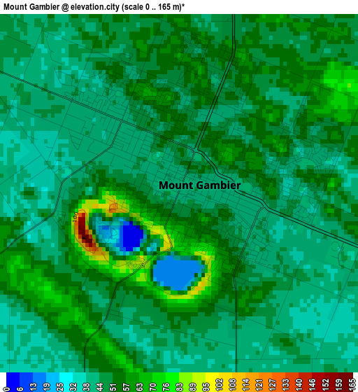
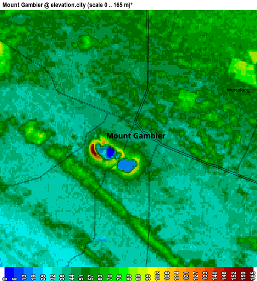
Below is the Elevation map of Mount Gambier, which displays elevation range with different colors. Scale of the first map is from 0 to 165 m (0 to 541 ft) with average elevation of 48.8 meters (=160 ft) [note 1]
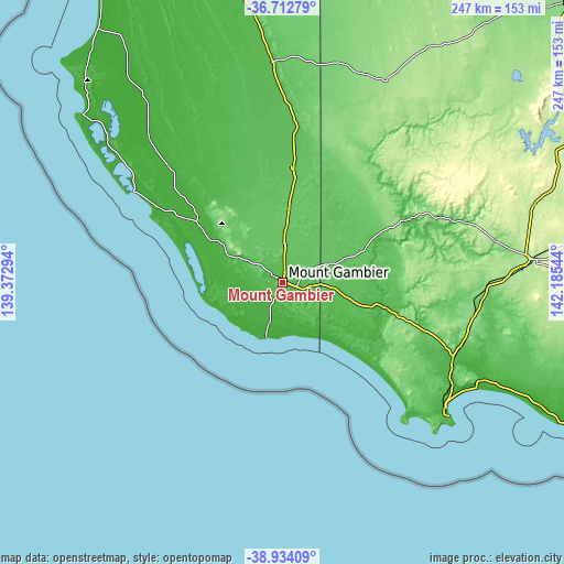
These maps also provides idea of topography and contour of this city, they are displayed at different zoom levels. More info about maps, scale and edge coordinates you can find below images.
| \ | Map #1 | Map #2 | Topo.Map |
| Scale [m] | 0..165 m | 0..165 m | × |
| Scale [ft] | 0..541 ft | 0..541 ft | × |
| Average | 48.8 m = 160 ft | 48.2 m = 158 ft | × |
| Width | 7.72 km = 4.8 mi | 15.44 km = 9.6 mi | 247 km = 153.5 mi |
| Height | 7.72 km = 4.8 mi | 15.44 km = 9.6 mi | 247 km = 153.5 mi |
| ↑Max Latitude | -37.797083° | -37.76235° | -36.71279° |
| Latitude at center | -37.8318° | -37.8318° | -37.8318° |
| ↓Min Latitude | -37.8665° | -37.901185° | -38.93409° |
| ← Min Longitude | 140.735245° | 140.691299° | 139.37294° |
| Longitude center | 140.77919° | 140.77919° | 140.77919° |
| →Max Longitude | 140.823135° | 140.867081° | 142.18544° |
Nearby cities:
Cities around Mount Gambier sort by population:
• Hamilton elevation 189 m
109.6 km,  84°
84°
• Portland 16 m
92 km,  128°
128°
• Naracoorte 57 m
97.2 km,  357°
357°
• Millicent 22 m
46.1 km,  304°
304°
• Port Fairy 10 m
141.6 km,  115°
115°
• Koroit 66 m
148.1 km,  110°
110°
• Heywood 29 m
81.7 km, 114°
• Casterton 49 m
61.4 km,  63°
63°
• Penola 62 m
51 km,  5°
5°
• Kingston South East 3 m
138.2 km,  323°
323°
• Moorak 38 m
4.8 km,  222°
222°
• Robe 4 m
116.6 km,  309°
309°
Multilingual:
 En español:
Mount Gambier elevación 41 m.
 En France:
Mont Gambier élévation 41 m.
 Auf Deutsch:
Mount Gambier höhe über dem Meeresspiegel ist 41 m.

Sources and notes:
- [note 1] Map square and city borders are not equal. Map elevation data is calculated only from area inside that square.
- [src 1] Elevation data from geonames database provided with same terms of usage.
- [src 2] The elevation map of Mount Gambier is generated using elevation data from NASA's 3 arcsec (90m) resolution SRTM data.
- [src 3] Base (background) map © OpenStreetMap contributors tiles are generated by Geofabrik and OpenTopoMap.
Copyright & License:
This Mount Gambier Elevation Map is licensed under CC BY-SA. You may reuse any part from this page, if you give a proper credit by linking to this URL:
 More info on terms of use page.