Mudgeeraba elevation
Mudgeeraba (Queensland, Gold Coast), Australia elevation is 1 meters and Mudgeeraba elevation in feet is 3 ft above sea level [src 1]. Mudgeeraba is a section of populated place (feature code) with elevation that is 112 meters (367 ft) smaller than average city elevation in Australia.
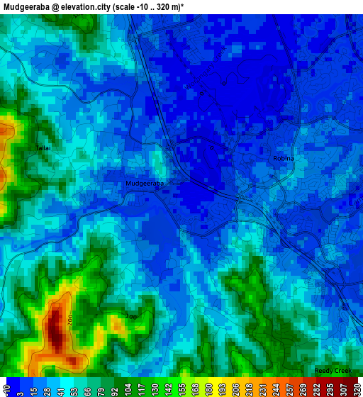
Below is the Elevation map of Mudgeeraba, which displays elevation range with different colors. Scale of the first map is from -10 to 320 m (-33 to 1050 ft) with average elevation of 46.2 meters (=152 ft) [note 1]
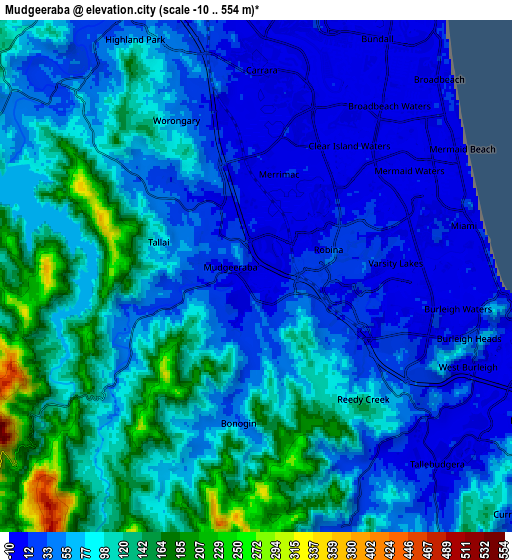
These maps also provides idea of topography and contour of this city, they are displayed at different zoom levels. More info about maps, scale and edge coordinates you can find below images.
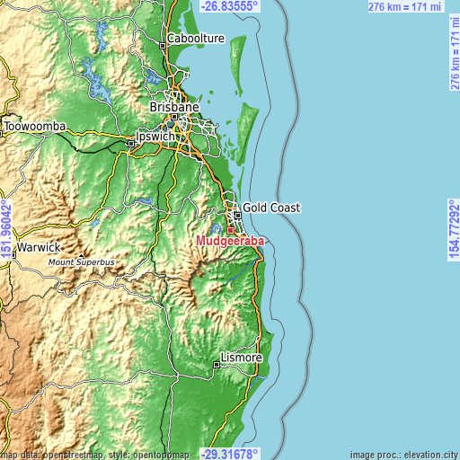
| \ | Map #1 | Map #2 | Topo.Map |
| Scale [m] | -10..320 m | -10..554 m | × |
| Scale [ft] | -33..1050 ft | -33..1818 ft | × |
| Average | 46.2 m = 152 ft | 75 m = 246 ft | × |
| Width | 8.62 km = 5.4 mi | 17.24 km = 10.7 mi | 275.9 km = 171.4 mi |
| Height | 8.62 km = 5.4 mi | 17.24 km = 10.7 mi | 275.9 km = 171.4 mi |
| ↑Max Latitude | -28.044552° | -28.005759° | -26.83555° |
| Latitude at center | -28.08333° | -28.08333° | -28.08333° |
| ↓Min Latitude | -28.122094° | -28.160845° | -29.31678° |
| ← Min Longitude | 153.322725° | 153.278779° | 151.96042° |
| Longitude center | 153.36667° | 153.36667° | 153.36667° |
| →Max Longitude | 153.410615° | 153.454561° | 154.77292° |
Nearby cities:
Cities around Mudgeeraba sort by population:
• Robina elevation 22 m
3 km,  61°
61°
• Varsity Lakes 5 m
4.5 km,  98°
98°
• Burleigh Waters 6 m
6 km,  107°
107°
• Mermaid Waters 4 m
7.4 km, 58°
• Carrara 1 m
6.9 km,  359°
359°
• Miami 4 m
7.5 km,  80°
80°
• Merrimac 3 m
3.7 km,  9°
9°
• Reedy Creek 47 m
4.4 km,  137°
137°
• Worongary 39 m
4.1 km,  336°
336°
• Bonogin 94 m
6.4 km,  192°
192°
• Clear Island Waters 3 m
4.6 km,  42°
42°
• Tallai 108 m
4.5 km,  298°
298°
Multilingual:
 En español:
Mudgeeraba elevación 1 m.
 En France:
Mudgeeraba élévation 1 m.
 Auf Deutsch:
Mudgeeraba höhe über dem Meeresspiegel ist 1 m.

Sources and notes:
- [note 1] Map square and city borders are not equal. Map elevation data is calculated only from area inside that square.
- [src 1] Elevation data from geonames database provided with same terms of usage.
- [src 2] The elevation map of Mudgeeraba is generated using elevation data from NASA's 3 arcsec (90m) resolution SRTM data.
- [src 3] Base (background) map © OpenStreetMap contributors tiles are generated by Geofabrik and OpenTopoMap.
Copyright & License:
This Mudgeeraba Elevation Map is licensed under CC BY-SA. You may reuse any part from this page, if you give a proper credit by linking to this URL:
 More info on terms of use page.