Mulgrave elevation
Mulgrave (Victoria, Monash), Australia elevation is 128 meters and Mulgrave elevation in feet is 420 ft above sea level [src 1]. Mulgrave is a section of populated place (feature code) with elevation that is 15 meters (49 ft) bigger than average city elevation in Australia.
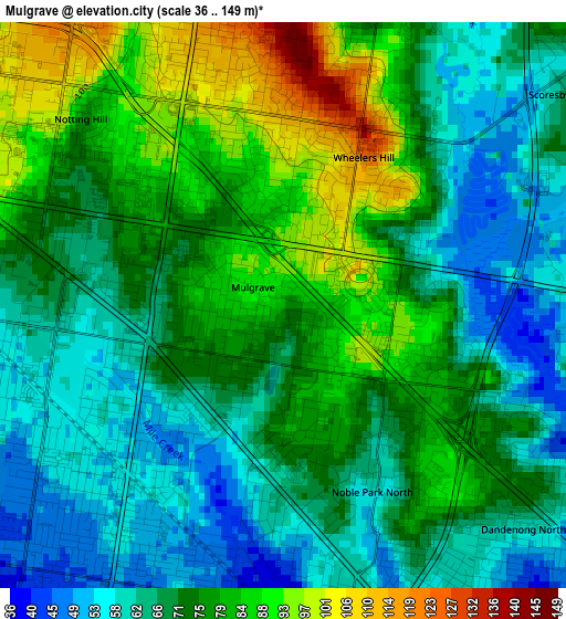
Below is the Elevation map of Mulgrave, which displays elevation range with different colors. Scale of the first map is from 36 to 149 m (118 to 489 ft) with average elevation of 72.6 meters (=238 ft) [note 1]
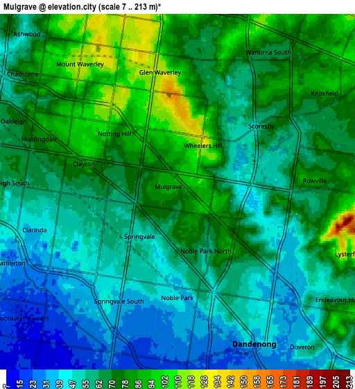
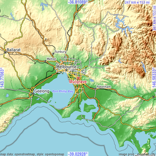
These maps also provides idea of topography and contour of this city, they are displayed at different zoom levels. More info about maps, scale and edge coordinates you can find below images.
| \ | Map #1 | Map #2 | Topo.Map |
| Scale [m] | 36..149 m | 7..213 m | × |
| Scale [ft] | 118..489 ft | 23..699 ft | × |
| Average | 72.6 m = 238 ft | 65.2 m = 214 ft | × |
| Width | 7.71 km = 4.8 mi | 15.42 km = 9.6 mi | 246.7 km = 153.3 mi |
| Height | 7.71 km = 4.8 mi | 15.42 km = 9.6 mi | 246.7 km = 153.3 mi |
| ↑Max Latitude | -37.893779° | -37.859091° | -36.81089° |
| Latitude at center | -37.92845° | -37.92845° | -37.92845° |
| ↓Min Latitude | -37.963105° | -37.997744° | -39.02928° |
| ← Min Longitude | 145.133135° | 145.089189° | 143.77083° |
| Longitude center | 145.17708° | 145.17708° | 145.17708° |
| →Max Longitude | 145.221025° | 145.264971° | 146.58333° |
Nearby cities:
Cities around Mulgrave sort by population:
• Glen Waverley elevation 121 m
5.7 km,  349°
349°
• Rowville 73 m
5 km,  96°
96°
• Noble Park 46 m
4.3 km,  192°
192°
• Dandenong North 53 m
5 km,  147°
147°
• Springvale 55 m
3.1 km,  223°
223°
• Clayton 70 m
5.5 km,  283°
283°
• Wheelers Hill 120 m
3.2 km,  9°
9°
• Springvale South 39 m
4.9 km,  209°
209°
• Clayton South 55 m
5.3 km,  264°
264°
• Noble Park North 58 m
2.7 km, 150°
• Scoresby 66 m
5.9 km,  57°
57°
• Notting Hill 101 m
4 km,  310°
310°
Multilingual:
 En español:
Mulgrave elevación 128 m.
 En France:
Mulgrave élévation 128 m.
 Auf Deutsch:
Mulgrave höhe über dem Meeresspiegel ist 128 m.

Sources and notes:
- [note 1] Map square and city borders are not equal. Map elevation data is calculated only from area inside that square.
- [src 1] Elevation data from geonames database provided with same terms of usage.
- [src 2] The elevation map of Mulgrave is generated using elevation data from NASA's 3 arcsec (90m) resolution SRTM data.
- [src 3] Base (background) map © OpenStreetMap contributors tiles are generated by Geofabrik and OpenTopoMap.
Copyright & License:
This Mulgrave Elevation Map is licensed under CC BY-SA. You may reuse any part from this page, if you give a proper credit by linking to this URL:
 More info on terms of use page.