Preston elevation
Preston (Victoria, Darebin), Australia elevation is 61 meters and Preston elevation in feet is 200 ft above sea level [src 1]. Preston is a section of populated place (feature code) with elevation that is 52 meters (171 ft) smaller than average city elevation in Australia.
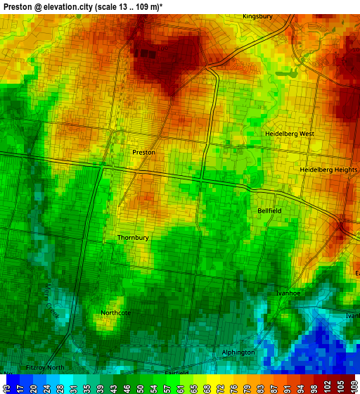
Below is the Elevation map of Preston, which displays elevation range with different colors. Scale of the first map is from 13 to 109 m (43 to 358 ft) with average elevation of 62.7 meters (=206 ft) [note 1]
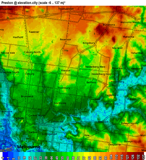
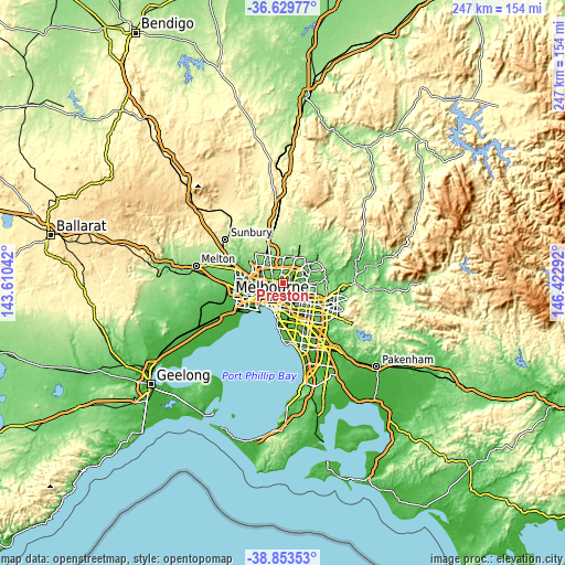
These maps also provides idea of topography and contour of this city, they are displayed at different zoom levels. More info about maps, scale and edge coordinates you can find below images.
| \ | Map #1 | Map #2 | Topo.Map |
| Scale [m] | 13..109 m | -6..137 m | × |
| Scale [ft] | 43..358 ft | -20..449 ft | × |
| Average | 62.7 m = 206 ft | 63.6 m = 209 ft | × |
| Width | 7.73 km = 4.8 mi | 15.45 km = 9.6 mi | 247.3 km = 153.7 mi |
| Height | 7.73 km = 4.8 mi | 15.45 km = 9.6 mi | 247.3 km = 153.7 mi |
| ↑Max Latitude | -37.715245° | -37.680473° | -36.62977° |
| Latitude at center | -37.75° | -37.75° | -37.75° |
| ↓Min Latitude | -37.784739° | -37.819462° | -38.85353° |
| ← Min Longitude | 144.972725° | 144.928779° | 143.61042° |
| Longitude center | 145.01667° | 145.01667° | 145.01667° |
| →Max Longitude | 145.060615° | 145.104561° | 146.42292° |
Nearby cities:
Cities around Preston sort by population:
• Reservoir elevation 89 m
4 km,  338°
338°
• Northcote 52 m
2.4 km,  218°
218°
• Thornbury 63 m
1.3 km,  226°
226°
• Ivanhoe 56 m
3.1 km,  132°
132°
• Heidelberg 39 m
4.4 km,  90°
90°
• Fairfield 39 m
3.3 km,  178°
178°
• Heidelberg Heights 85 m
3.6 km,  77°
77°
• Heidelberg West 63 m
2.4 km,  60°
60°
• Alphington 36 m
4 km,  158°
158°
• Eaglemont 59 m
4.4 km,  110°
110°
• Kingsbury 85 m
4.3 km,  22°
22°
• Bellfield 64 m
1.9 km,  100°
100°
Multilingual:
 En español:
Preston elevación 61 m.
 En France:
Preston élévation 61 m.


Sources and notes:
- [note 1] Map square and city borders are not equal. Map elevation data is calculated only from area inside that square.
- [src 1] Elevation data from geonames database provided with same terms of usage.
- [src 2] The elevation map of Preston is generated using elevation data from NASA's 3 arcsec (90m) resolution SRTM data.
- [src 3] Base (background) map © OpenStreetMap contributors tiles are generated by Geofabrik and OpenTopoMap.
Copyright & License:
This Preston Elevation Map is licensed under CC BY-SA. You may reuse any part from this page, if you give a proper credit by linking to this URL:
 More info on terms of use page.