Rhodes elevation
Rhodes (New South Wales, Canada Bay), Australia elevation is 22 meters and Rhodes elevation in feet is 72 ft above sea level [src 1]. Rhodes is a section of populated place (feature code) with elevation that is 91 meters (299 ft) smaller than average city elevation in Australia.
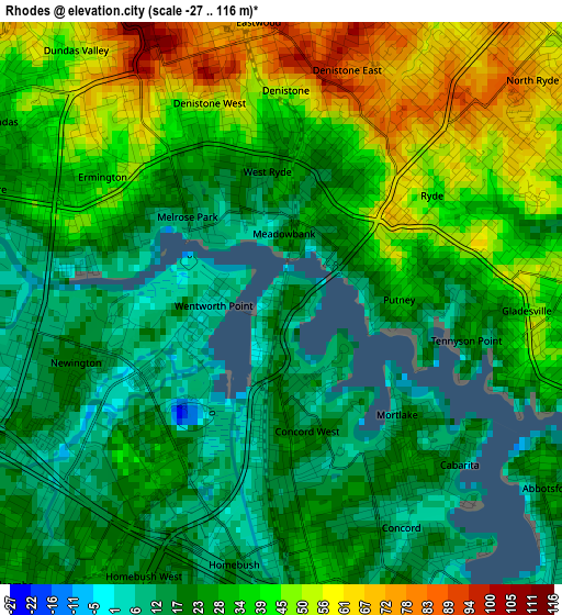
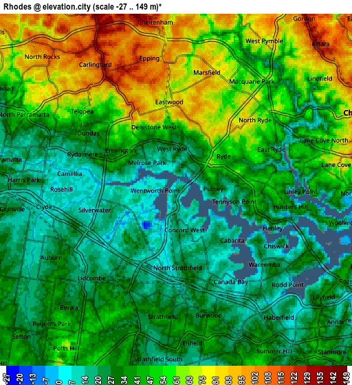
Below is the Elevation map of Rhodes, which displays elevation range with different colors. Scale of the first map is from -27 to 116 m (-89 to 381 ft) with average elevation of 30.7 meters (=101 ft) [note 1]
These maps also provides idea of topography and contour of this city, they are displayed at different zoom levels. More info about maps, scale and edge coordinates you can find below images.
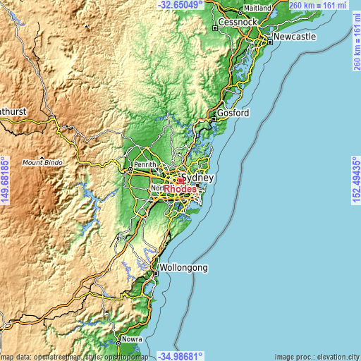
| \ | Map #1 | Map #2 | Topo.Map |
| Scale [m] | -27..116 m | -27..149 m | × |
| Scale [ft] | -89..381 ft | -89..489 ft | × |
| Average | 30.7 m = 101 ft | 44.1 m = 145 ft | × |
| Width | 8.12 km = 5 mi | 16.24 km = 10.1 mi | 259.8 km = 161.4 mi |
| Height | 8.12 km = 5 mi | 16.24 km = 10.1 mi | 259.8 km = 161.4 mi |
| ↑Max Latitude | -33.790116° | -33.753586° | -32.65049° |
| Latitude at center | -33.82663° | -33.82663° | -33.82663° |
| ↓Min Latitude | -33.863129° | -33.899612° | -34.98681° |
| ← Min Longitude | 151.044155° | 151.000209° | 149.68185° |
| Longitude center | 151.0881° | 151.0881° | 151.0881° |
| →Max Longitude | 151.132045° | 151.175991° | 152.49435° |
Nearby cities:
Cities around Rhodes sort by population:
• Ryde elevation 39 m
1.9 km,  62°
62°
• Concord 20 m
2.7 km,  147°
147°
• West Ryde 31 m
2.7 km,  330°
330°
• Wentworth Point 4 m
1.3 km,  249°
249°
• Concord West 16 m
2.4 km,  184°
184°
• Meadowbank 14 m
1.1 km,  2°
2°
• Breakfast Point 17 m
2.8 km,  130°
130°
• Putney 35 m
1.7 km,  88°
88°
• Liberty Grove 9 m
1.6 km,  193°
193°
• Melrose Park 12 m
2 km,  311°
311°
• Tennyson Point 24 m
2.7 km,  102°
102°
• Mortlake 19 m
2.5 km, 134°
Multilingual:
 En español:
Rhodes elevación 22 m.
 En France:
Rhodes élévation 22 m.


Sources and notes:
- [note 1] Map square and city borders are not equal. Map elevation data is calculated only from area inside that square.
- [src 1] Elevation data from geonames database provided with same terms of usage.
- [src 2] The elevation map of Rhodes is generated using elevation data from NASA's 3 arcsec (90m) resolution SRTM data.
- [src 3] Base (background) map © OpenStreetMap contributors tiles are generated by Geofabrik and OpenTopoMap.
Copyright & License:
This Rhodes Elevation Map is licensed under CC BY-SA. You may reuse any part from this page, if you give a proper credit by linking to this URL:
 More info on terms of use page.