Roseville elevation
Roseville (New South Wales, Ku-ring-gai), Australia elevation is 88 meters and Roseville elevation in feet is 289 ft above sea level [src 1]. Roseville is a section of populated place (feature code) with elevation that is 25 meters (82 ft) smaller than average city elevation in Australia.
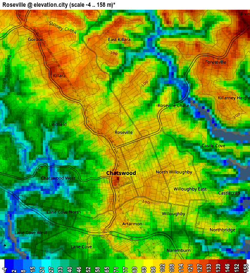
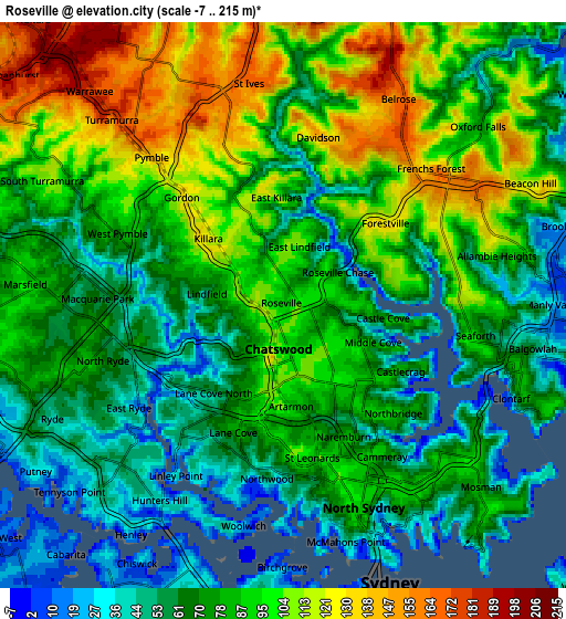
Below is the Elevation map of Roseville, which displays elevation range with different colors. Scale of the first map is from -4 to 158 m (-13 to 518 ft) with average elevation of 76.6 meters (=251 ft) [note 1]
These maps also provides idea of topography and contour of this city, they are displayed at different zoom levels. More info about maps, scale and edge coordinates you can find below images.
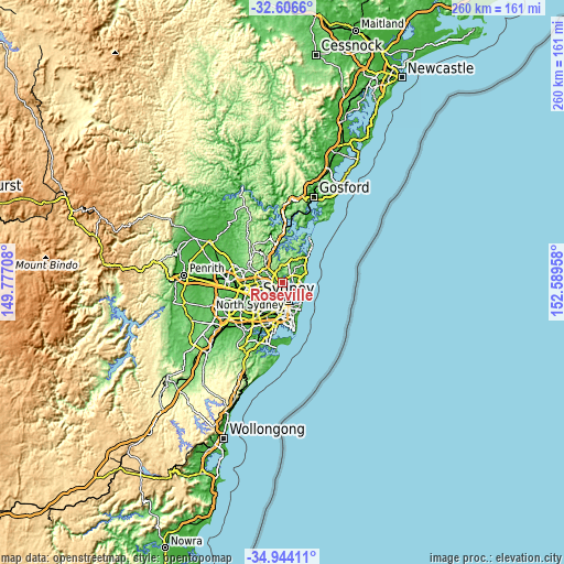
| \ | Map #1 | Map #2 | Topo.Map |
| Scale [m] | -4..158 m | -7..215 m | × |
| Scale [ft] | -13..518 ft | -23..705 ft | × |
| Average | 76.6 m = 251 ft | 82.3 m = 270 ft | × |
| Width | 8.12 km = 5 mi | 16.24 km = 10.1 mi | 259.9 km = 161.5 mi |
| Height | 8.12 km = 5 mi | 16.24 km = 10.1 mi | 259.9 km = 161.5 mi |
| ↑Max Latitude | -33.746797° | -33.710249° | -32.6066° |
| Latitude at center | -33.78333° | -33.78333° | -33.78333° |
| ↓Min Latitude | -33.819847° | -33.856349° | -34.94411° |
| ← Min Longitude | 151.139385° | 151.095439° | 149.77708° |
| Longitude center | 151.18333° | 151.18333° | 151.18333° |
| →Max Longitude | 151.227275° | 151.271221° | 152.58958° |
Nearby cities:
Cities around Roseville sort by population:
• Chatswood elevation 108 m
1.9 km,  180°
180°
• Lane Cove North 64 m
2.9 km,  212°
212°
• Killara 116 m
2.7 km,  314°
314°
• Lindfield 84 m
1.5 km,  270°
270°
• Willoughby 86 m
2.8 km,  148°
148°
• North Willoughby 94 m
2.1 km,  130°
130°
• East Lindfield 111 m
1.9 km,  9°
9°
• Castle Cove 66 m
2.4 km,  98°
98°
• Willoughby East 82 m
2.6 km, 129°
• Roseville Chase 99 m
1.4 km,  66°
66°
• Chatswood West 59 m
2.1 km,  235°
235°
• Middle Cove 59 m
2.9 km,  111°
111°
Multilingual:
 En español:
Roseville elevación 88 m.
 En France:
Roseville élévation 88 m.
 Auf Deutsch:
Roseville höhe über dem Meeresspiegel ist 88 m.

Sources and notes:
- [note 1] Map square and city borders are not equal. Map elevation data is calculated only from area inside that square.
- [src 1] Elevation data from geonames database provided with same terms of usage.
- [src 2] The elevation map of Roseville is generated using elevation data from NASA's 3 arcsec (90m) resolution SRTM data.
- [src 3] Base (background) map © OpenStreetMap contributors tiles are generated by Geofabrik and OpenTopoMap.
Copyright & License:
This Roseville Elevation Map is licensed under CC BY-SA. You may reuse any part from this page, if you give a proper credit by linking to this URL:
 More info on terms of use page.