Rutherford elevation
Rutherford (New South Wales, Maitland Municipality), Australia elevation is 38 meters and Rutherford elevation in feet is 125 ft above sea level [src 1]. Rutherford is a section of populated place (feature code) with elevation that is 75 meters (246 ft) smaller than average city elevation in Australia.
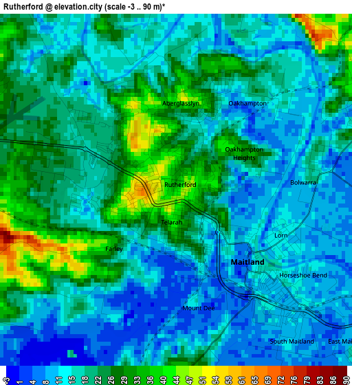
Below is the Elevation map of Rutherford, which displays elevation range with different colors. Scale of the first map is from -3 to 90 m (-10 to 295 ft) with average elevation of 19.1 meters (=63 ft) [note 1]
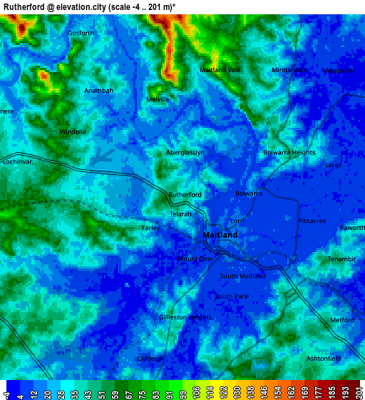
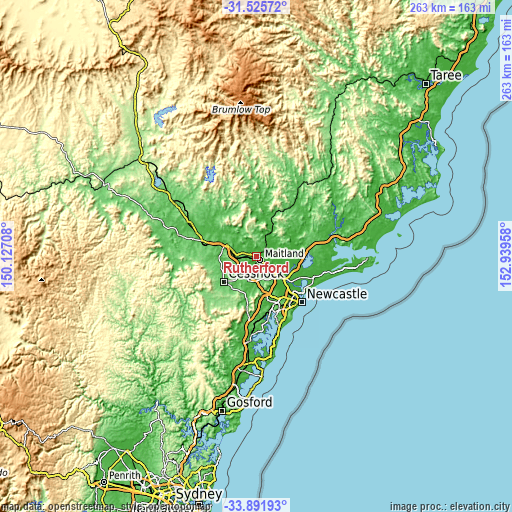
These maps also provides idea of topography and contour of this city, they are displayed at different zoom levels. More info about maps, scale and edge coordinates you can find below images.
| \ | Map #1 | Map #2 | Topo.Map |
| Scale [m] | -3..90 m | -4..201 m | × |
| Scale [ft] | -10..295 ft | -13..659 ft | × |
| Average | 19.1 m = 63 ft | 28.6 m = 94 ft | × |
| Width | 8.22 km = 5.1 mi | 16.44 km = 10.2 mi | 263.1 km = 163.5 mi |
| Height | 8.22 km = 5.1 mi | 16.44 km = 10.2 mi | 263.1 km = 163.5 mi |
| ↑Max Latitude | -32.679689° | -32.642692° | -31.52572° |
| Latitude at center | -32.71667° | -32.71667° | -32.71667° |
| ↓Min Latitude | -32.753636° | -32.790586° | -33.89193° |
| ← Min Longitude | 151.489385° | 151.445439° | 150.12708° |
| Longitude center | 151.53333° | 151.53333° | 151.53333° |
| →Max Longitude | 151.577275° | 151.621221° | 152.93958° |
Nearby cities:
Cities around Rutherford sort by population:
• Maitland elevation 115 m
2.9 km,  129°
129°
• East Maitland 24 m
6 km, 128°
• Aberglasslyn 33 m
1.9 km,  0°
0°
• Metford 28 m
8.9 km, 127°
• Gillieston Heights 39 m
5 km,  185°
185°
• Bolwarra Heights 44 m
5.2 km,  70°
70°
• Tenambit 28 m
7.9 km,  108°
108°
• Telarah 3 m
1.3 km,  175°
175°
• Maitland city centre 115 m
2.6 km, 133°
• Largs 26 m
6.5 km, 73°
• Raworth 28 m
8 km,  103°
103°
• Lorn 13 m
3.8 km, 107°
Multilingual:
 En español:
Rutherford elevación 38 m.
 En France:
Rutherford élévation 38 m.
 Auf Deutsch:
Rutherford höhe über dem Meeresspiegel ist 38 m.

Sources and notes:
- [note 1] Map square and city borders are not equal. Map elevation data is calculated only from area inside that square.
- [src 1] Elevation data from geonames database provided with same terms of usage.
- [src 2] The elevation map of Rutherford is generated using elevation data from NASA's 3 arcsec (90m) resolution SRTM data.
- [src 3] Base (background) map © OpenStreetMap contributors tiles are generated by Geofabrik and OpenTopoMap.
Copyright & License:
This Rutherford Elevation Map is licensed under CC BY-SA. You may reuse any part from this page, if you give a proper credit by linking to this URL:
 More info on terms of use page.