Seymour elevation
Seymour (Victoria, Mitchell), Australia elevation is 148 meters and Seymour elevation in feet is 486 ft above sea level [src 1]. Seymour is a populated place (feature code) with elevation that is 35 meters (115 ft) bigger than average city elevation in Australia.
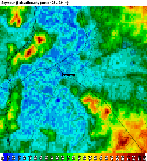
Below is the Elevation map of Seymour, which displays elevation range with different colors. Scale of the first map is from 128 to 224 m (420 to 735 ft) with average elevation of 156.8 meters (=514 ft) [note 1]
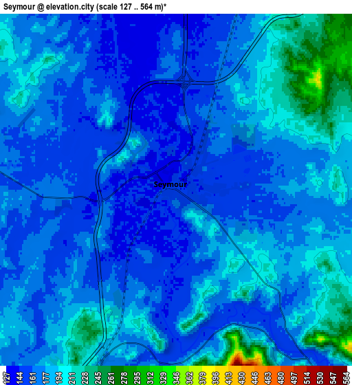
These maps also provides idea of topography and contour of this city, they are displayed at different zoom levels. More info about maps, scale and edge coordinates you can find below images.
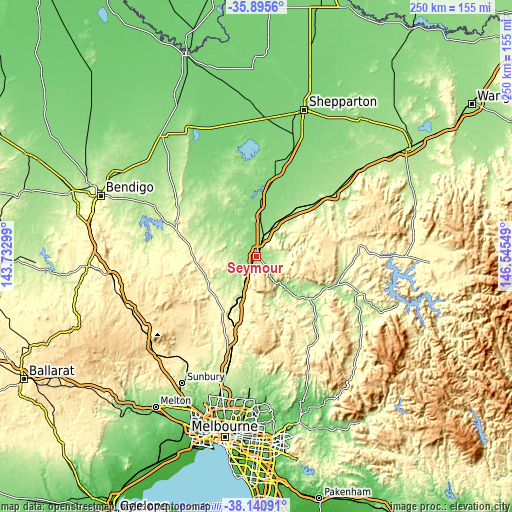
| \ | Map #1 | Map #2 | Topo.Map |
| Scale [m] | 128..224 m | 127..564 m | × |
| Scale [ft] | 420..735 ft | 417..1850 ft | × |
| Average | 156.8 m = 514 ft | 176.9 m = 580 ft | × |
| Width | 7.8 km = 4.8 mi | 15.6 km = 9.7 mi | 249.7 km = 155.2 mi |
| Height | 7.8 km = 4.8 mi | 15.6 km = 9.7 mi | 249.7 km = 155.2 mi |
| ↑Max Latitude | -36.991458° | -36.95635° | -35.8956° |
| Latitude at center | -37.02655° | -37.02655° | -37.02655° |
| ↓Min Latitude | -37.061626° | -37.096686° | -38.14091° |
| ← Min Longitude | 145.095295° | 145.051349° | 143.73299° |
| Longitude center | 145.13924° | 145.13924° | 145.13924° |
| →Max Longitude | 145.183185° | 145.227131° | 146.54549° |
Nearby cities:
Cities around Seymour sort by population:
• Wallan elevation 321 m
45.6 km,  198°
198°
• Kilmore 354 m
34.2 km,  208°
208°
• Broadford 213 m
21.2 km, 202°
• Euroa 179 m
48.8 km,  51°
51°
• Heathcote 239 m
40 km,  286°
286°
• Lancefield 480 m
45.3 km,  232°
232°
• Nagambie 132 m
26.9 km,  2°
2°
• Yea 170 m
32.7 km,  128°
128°
• Wandong 365 m
39.6 km,  193°
193°
• Puckapunyal 185 m
9.5 km, 291°
• Kinglake West 492 m
49.6 km,  170°
170°
• Avenel 157 m
16.3 km,  30°
30°
Multilingual:
 En español:
Seymour elevación 148 m.
 En France:
Seymour élévation 148 m.


Sources and notes:
- [note 1] Map square and city borders are not equal. Map elevation data is calculated only from area inside that square.
- [src 1] Elevation data from geonames database provided with same terms of usage.
- [src 2] The elevation map of Seymour is generated using elevation data from NASA's 3 arcsec (90m) resolution SRTM data.
- [src 3] Base (background) map © OpenStreetMap contributors tiles are generated by Geofabrik and OpenTopoMap.
Copyright & License:
This Seymour Elevation Map is licensed under CC BY-SA. You may reuse any part from this page, if you give a proper credit by linking to this URL:
 More info on terms of use page.