Table Top elevation
Table Top (New South Wales, Albury Municipality), Australia elevation is 248 meters and Table Top elevation in feet is 814 ft above sea level [src 1]. Table Top is a section of populated place (feature code) with elevation that is 135 meters (443 ft) bigger than average city elevation in Australia.
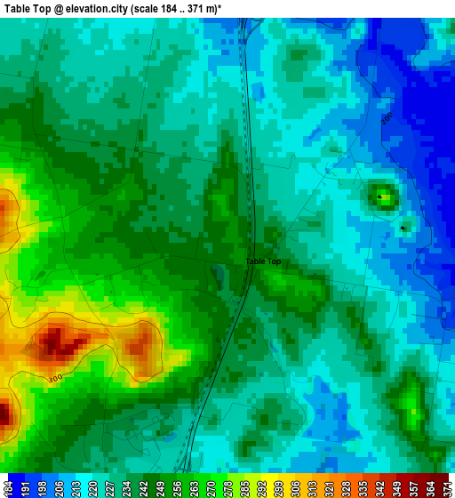
Below is the Elevation map of Table Top, which displays elevation range with different colors. Scale of the first map is from 184 to 371 m (604 to 1217 ft) with average elevation of 236.2 meters (=775 ft) [note 1]
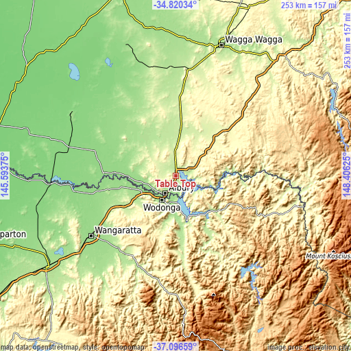
These maps also provides idea of topography and contour of this city, they are displayed at different zoom levels. More info about maps, scale and edge coordinates you can find below images.
| \ | Map #1 | Topo.Map |
| Scale [m] | 184..371 m | × |
| Scale [ft] | 604..1217 ft | × |
| Average | 236.2 m = 775 ft | × |
| Width | 7.91 km = 4.9 mi | 253.1 km = 157.3 mi |
| Height | 7.91 km = 4.9 mi | 253.1 km = 157.3 mi |
| ↑Max Latitude | -35.931094° | -34.82034° |
| Latitude at center | -35.96667° | -35.96667° |
| ↓Min Latitude | -36.00223° | -37.09659° |
| ← Min Longitude | 146.956055° | 145.59375° |
| Longitude center | 147° | 147° |
| →Max Longitude | 147.043945° | 148.40625° |
Nearby cities:
Cities around Table Top sort by population:
• Wodonga elevation 167 m
20 km,  210°
210°
• West Wodonga 175 m
21.9 km,  217°
217°
• Lavington 194 m
9.8 km, 213°
• Thurgoona 190 m
7.7 km,  182°
182°
• East Albury 179 m
14.2 km, 206°
• North Albury 177 m
11.9 km, 211°
• Albury 164 m
13.8 km, 209°
• West Albury 167 m
15.9 km, 217°
• Glenroy 191 m
12.3 km, 220°
• Jindera 233 m
10.1 km,  277°
277°
• Springdale Heights 203 m
8.6 km, 213°
• South Albury 153 m
15.6 km, 211°
Multilingual:
 En español:
Table Top elevación 248 m.
 En France:
Table Top élévation 248 m.
 Auf Deutsch:
Table Top höhe über dem Meeresspiegel ist 248 m.

Sources and notes:
- [note 1] Map square and city borders are not equal. Map elevation data is calculated only from area inside that square.
- [src 1] Elevation data from geonames database provided with same terms of usage.
- [src 2] The elevation map of Table Top is generated using elevation data from NASA's 3 arcsec (90m) resolution SRTM data.
- [src 3] Base (background) map © OpenStreetMap contributors tiles are generated by Geofabrik and OpenTopoMap.
Copyright & License:
This Table Top Elevation Map is licensed under CC BY-SA. You may reuse any part from this page, if you give a proper credit by linking to this URL:
 More info on terms of use page.