Upwey elevation
Upwey (Victoria, Yarra Ranges), Australia elevation is 219 meters and Upwey elevation in feet is 719 ft above sea level [src 1]. Upwey is a section of populated place (feature code) with elevation that is 106 meters (348 ft) bigger than average city elevation in Australia.
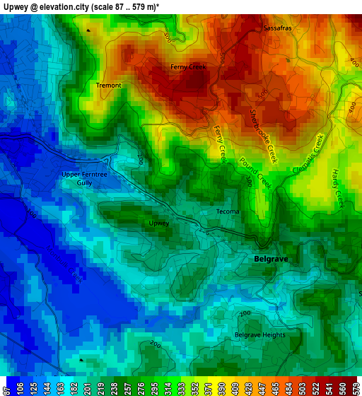
Below is the Elevation map of Upwey, which displays elevation range with different colors. Scale of the first map is from 87 to 579 m (285 to 1900 ft) with average elevation of 262.9 meters (=863 ft) [note 1]
These maps also provides idea of topography and contour of this city, they are displayed at different zoom levels. More info about maps, scale and edge coordinates you can find below images.
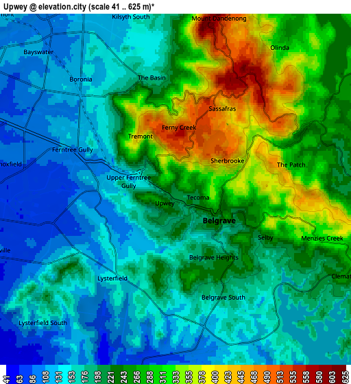
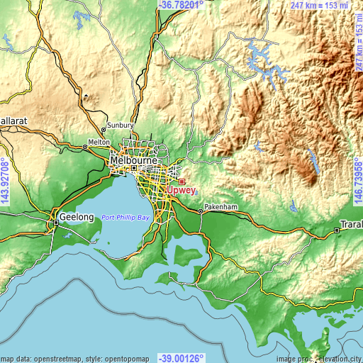
| \ | Map #1 | Map #2 | Topo.Map |
| Scale [m] | 87..579 m | 41..625 m | × |
| Scale [ft] | 285..1900 ft | 135..2051 ft | × |
| Average | 262.9 m = 863 ft | 215.2 m = 706 ft | × |
| Width | 7.71 km = 4.8 mi | 15.42 km = 9.6 mi | 246.8 km = 153.4 mi |
| Height | 7.71 km = 4.8 mi | 15.42 km = 9.6 mi | 246.8 km = 153.4 mi |
| ↑Max Latitude | -37.865315° | -37.830614° | -36.78201° |
| Latitude at center | -37.9° | -37.9° | -37.9° |
| ↓Min Latitude | -37.934668° | -37.96932° | -39.00126° |
| ← Min Longitude | 145.289385° | 145.245439° | 143.92708° |
| Longitude center | 145.33333° | 145.33333° | 145.33333° |
| →Max Longitude | 145.377275° | 145.421221° | 146.73958° |
Nearby cities:
Cities around Upwey sort by population:
• Ferntree Gully elevation 125 m
3.7 km,  297°
297°
• Boronia 109 m
5.7 km,  310°
310°
• Lysterfield 140 m
4.7 km,  218°
218°
• The Basin 171 m
5.7 km,  345°
345°
• Belgrave 324 m
2.2 km,  124°
124°
• Tecoma 218 m
1.1 km,  108°
108°
• Selby 328 m
4.8 km, 112°
• Belgrave South 192 m
3.7 km,  180°
180°
• Ferny Creek 520 m
1.9 km,  0°
0°
• Kallista 418 m
4.3 km,  87°
87°
• Belgrave Heights 185 m
3.1 km,  162°
162°
• Sassafras 542 m
4 km,  21°
21°
Multilingual:
 En español:
Upwey elevación 219 m.
 En France:
Upwey élévation 219 m.


Sources and notes:
- [note 1] Map square and city borders are not equal. Map elevation data is calculated only from area inside that square.
- [src 1] Elevation data from geonames database provided with same terms of usage.
- [src 2] The elevation map of Upwey is generated using elevation data from NASA's 3 arcsec (90m) resolution SRTM data.
- [src 3] Base (background) map © OpenStreetMap contributors tiles are generated by Geofabrik and OpenTopoMap.
Copyright & License:
This Upwey Elevation Map is licensed under CC BY-SA. You may reuse any part from this page, if you give a proper credit by linking to this URL:
 More info on terms of use page.