Warburton elevation
Warburton (Victoria, Yarra Ranges), Australia elevation is 159 meters and Warburton elevation in feet is 522 ft above sea level [src 1]. Warburton is a section of populated place (feature code) with elevation that is 46 meters (151 ft) bigger than average city elevation in Australia.
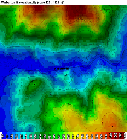
Below is the Elevation map of Warburton, which displays elevation range with different colors. Scale of the first map is from 129 to 1121 m (423 to 3678 ft) with average elevation of 451.1 meters (=1480 ft) [note 1]
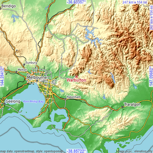
These maps also provides idea of topography and contour of this city, they are displayed at different zoom levels. More info about maps, scale and edge coordinates you can find below images.
| \ | Map #1 | Topo.Map |
| Scale [m] | 129..1121 m | × |
| Scale [ft] | 423..3678 ft | × |
| Average | 451.1 m = 1480 ft | × |
| Width | 7.73 km = 4.8 mi | 247.2 km = 153.6 mi |
| Height | 7.73 km = 4.8 mi | 247.2 km = 153.6 mi |
| ↑Max Latitude | -37.718997° | -36.63357° |
| Latitude at center | -37.75375° | -37.75375° |
| ↓Min Latitude | -37.788487° | -38.85722° |
| ← Min Longitude | 145.646425° | 144.28412° |
| Longitude center | 145.69037° | 145.69037° |
| →Max Longitude | 145.734315° | 147.09662° |
Nearby cities:
Cities around Warburton sort by population:
• Healesville elevation 97 m
18.8 km,  306°
306°
• Cockatoo 215 m
26.7 km,  220°
220°
• Wandin North 181 m
22.8 km,  261°
261°
• Woori Yallock 159 m
13.7 km, 257°
• Yarra Junction 125 m
7.4 km,  244°
244°
• Gembrook 322 m
25.1 km,  208°
208°
• Launching Place 149 m
11.1 km,  254°
254°
• Seville 151 m
18.5 km, 254°
• Millgrove 140 m
3.2 km,  267°
267°
• Badger Creek 81 m
16.4 km,  291°
291°
• Silvan 224 m
25 km, 253°
• Wesburn 124 m
5.2 km, 254°
Multilingual:
 En español:
Warburton elevación 159 m.
 En France:
Warburton élévation 159 m.
 Auf Deutsch:
Warburton höhe über dem Meeresspiegel ist 159 m.

Sources and notes:
- [note 1] Map square and city borders are not equal. Map elevation data is calculated only from area inside that square.
- [src 1] Elevation data from geonames database provided with same terms of usage.
- [src 2] The elevation map of Warburton is generated using elevation data from NASA's 3 arcsec (90m) resolution SRTM data.
- [src 3] Base (background) map © OpenStreetMap contributors tiles are generated by Geofabrik and OpenTopoMap.
Copyright & License:
This Warburton Elevation Map is licensed under CC BY-SA. You may reuse any part from this page, if you give a proper credit by linking to this URL:
 More info on terms of use page.