Windsor elevation
Windsor (Victoria, Stonnington), Australia elevation is 25 meters and Windsor elevation in feet is 82 ft above sea level [src 1]. Windsor is a section of populated place (feature code) with elevation that is 88 meters (289 ft) smaller than average city elevation in Australia.
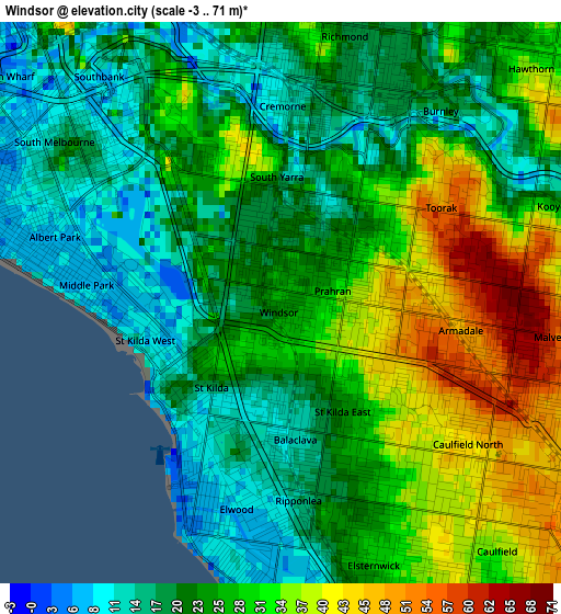
Below is the Elevation map of Windsor, which displays elevation range with different colors. Scale of the first map is from -3 to 71 m (-10 to 233 ft) with average elevation of 25.7 meters (=84 ft) [note 1]
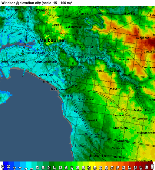
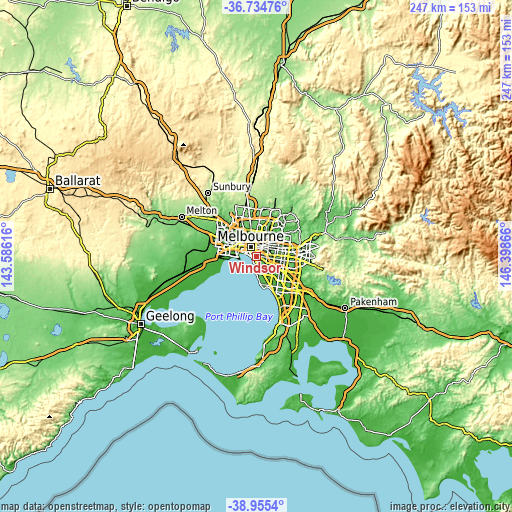
These maps also provides idea of topography and contour of this city, they are displayed at different zoom levels. More info about maps, scale and edge coordinates you can find below images.
| \ | Map #1 | Map #2 | Topo.Map |
| Scale [m] | -3..71 m | -15..106 m | × |
| Scale [ft] | -10..233 ft | -49..348 ft | × |
| Average | 25.7 m = 84 ft | 32.4 m = 106 ft | × |
| Width | 7.72 km = 4.8 mi | 15.43 km = 9.6 mi | 246.9 km = 153.4 mi |
| Height | 7.72 km = 4.8 mi | 15.43 km = 9.6 mi | 246.9 km = 153.4 mi |
| ↑Max Latitude | -37.818733° | -37.78401° | -36.73476° |
| Latitude at center | -37.85344° | -37.85344° | -37.85344° |
| ↓Min Latitude | -37.88813° | -37.922804° | -38.9554° |
| ← Min Longitude | 144.948465° | 144.904519° | 143.58616° |
| Longitude center | 144.99241° | 144.99241° | 144.99241° |
| →Max Longitude | 145.036355° | 145.080301° | 146.39866° |
Nearby cities:
Cities around Windsor sort by population:
• South Yarra elevation 37 m
1.7 km,  357°
357°
• Saint Kilda 11 m
1.9 km,  212°
212°
• St Kilda East 21 m
1.5 km,  153°
153°
• Prahran 26 m
0.3 km,  14°
14°
• Toorak 55 m
2.3 km,  55°
55°
• South Melbourne 9 m
3.2 km,  314°
314°
• Malvern 60 m
3.3 km,  107°
107°
• Armadale 52 m
2.5 km,  95°
95°
• Balaclava 21 m
1.6 km,  155°
155°
• Middle Park 7 m
2.7 km,  275°
275°
• St Kilda West 11 m
2 km,  249°
249°
• Cremorne 104 m
2.4 km,  2°
2°
Multilingual:
 En español:
Windsor elevación 25 m.
 En France:
Windsor élévation 25 m.


Sources and notes:
- [note 1] Map square and city borders are not equal. Map elevation data is calculated only from area inside that square.
- [src 1] Elevation data from geonames database provided with same terms of usage.
- [src 2] The elevation map of Windsor is generated using elevation data from NASA's 3 arcsec (90m) resolution SRTM data.
- [src 3] Base (background) map © OpenStreetMap contributors tiles are generated by Geofabrik and OpenTopoMap.
Copyright & License:
This Windsor Elevation Map is licensed under CC BY-SA. You may reuse any part from this page, if you give a proper credit by linking to this URL:
 More info on terms of use page.