Leanyer elevation
Leanyer (Northern Territory, Darwin), Australia elevation is 19 meters and Leanyer elevation in feet is 62 ft above sea level [src 1]. Leanyer is a section of populated place (feature code) with elevation that is 94 meters (308 ft) smaller than average city elevation in Australia.
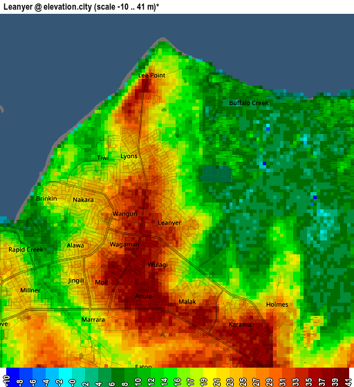
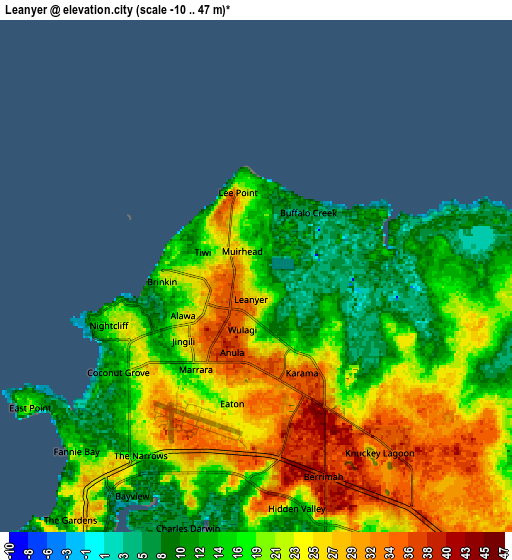
Below is the Elevation map of Leanyer, which displays elevation range with different colors. Scale of the first map is from -10 to 41 m (-33 to 135 ft) with average elevation of 17.9 meters (=59 ft) [note 1]
These maps also provides idea of topography and contour of this city, they are displayed at different zoom levels. More info about maps, scale and edge coordinates you can find below images.
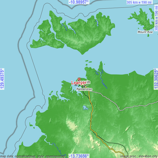
| \ | Map #1 | Map #2 | Topo.Map |
| Scale [m] | -10..41 m | -10..47 m | × |
| Scale [ft] | -33..135 ft | -33..154 ft | × |
| Average | 17.9 m = 59 ft | 20.1 m = 66 ft | × |
| Width | 9.55 km = 5.9 mi | 19.09 km = 11.9 mi | 305.4 km = 189.8 mi |
| Height | 9.55 km = 5.9 mi | 19.09 km = 11.9 mi | 305.5 km = 189.8 mi |
| ↑Max Latitude | -12.323741° | -12.280805° | -10.98957° |
| Latitude at center | -12.36667° | -12.36667° | -12.36667° |
| ↓Min Latitude | -12.409592° | -12.452507° | -13.73656° |
| ← Min Longitude | 130.856055° | 130.812109° | 129.49375° |
| Longitude center | 130.9° | 130.9° | 130.9° |
| →Max Longitude | 130.943945° | 130.987891° | 132.30625° |
Nearby cities:
Cities around Leanyer sort by population:
• Malak elevation 24 m
2.9 km,  171°
171°
• Tiwi 11 m
2.5 km,  290°
290°
• Wulagi 31 m
1.9 km,  194°
194°
• Muirhead 28 m
1.1 km,  321°
321°
• Anula 40 m
2.9 km,  200°
200°
• Lyons 21 m
1.5 km,  303°
303°
• Wagaman 31 m
2.2 km,  225°
225°
• Alawa 20 m
3.2 km,  243°
243°
• Nakara 21 m
2.5 km,  260°
260°
• Moil 35 m
3.2 km,  220°
220°
• Wanguri 33 m
1.4 km,  248°
248°
• Brinkin 15 m
3.5 km, 262°
Multilingual:
 En español:
Leanyer elevación 19 m.
 En France:
Leanyer élévation 19 m.


Sources and notes:
- [note 1] Map square and city borders are not equal. Map elevation data is calculated only from area inside that square.
- [src 1] Elevation data from geonames database provided with same terms of usage.
- [src 2] The elevation map of Leanyer is generated using elevation data from NASA's 3 arcsec (90m) resolution SRTM data.
- [src 3] Base (background) map © OpenStreetMap contributors tiles are generated by Geofabrik and OpenTopoMap.
Copyright & License:
This Leanyer Elevation Map is licensed under CC BY-SA. You may reuse any part from this page, if you give a proper credit by linking to this URL:
 More info on terms of use page.