Eaton elevation
Eaton (Western Australia, Dardanup), Australia elevation is 9 meters and Eaton elevation in feet is 30 ft above sea level [src 1]. Eaton is a section of populated place (feature code) with elevation that is 104 meters (341 ft) smaller than average city elevation in Australia.
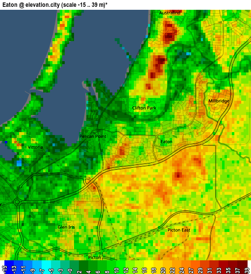
Below is the Elevation map of Eaton, which displays elevation range with different colors. Scale of the first map is from -15 to 39 m (-49 to 128 ft) with average elevation of 13.4 meters (=44 ft) [note 1]
These maps also provides idea of topography and contour of this city, they are displayed at different zoom levels. More info about maps, scale and edge coordinates you can find below images.
| \ | Map #1 | Map #2 | Topo.Map |
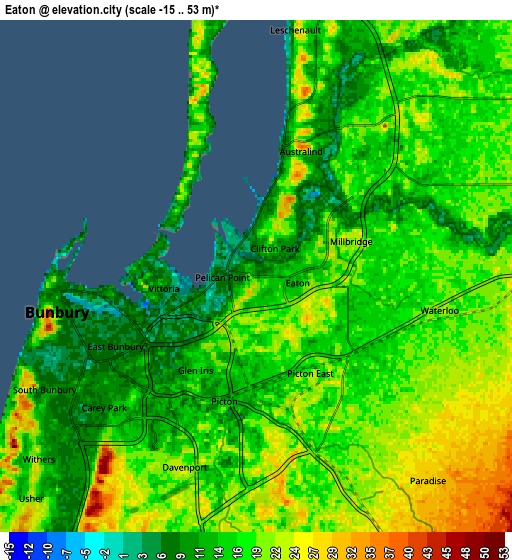
| Scale [m] | -15..39 m | -15..53 m | × |
| Scale [ft] | -49..128 ft | -49..174 ft | × |
| Average | 13.4 m = 44 ft | 17.1 m = 56 ft | × |
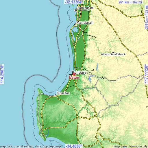
| Width | 8.17 km = 5.1 mi | 16.33 km = 10.1 mi | 261.3 km = 162.4 mi |
| Height | 8.17 km = 5.1 mi | 16.33 km = 10.1 mi | 261.3 km = 162.4 mi |
| ↑Max Latitude | -33.279909° | -33.243163° | -32.13364° |
| Latitude at center | -33.31664° | -33.31664° | -33.31664° |
| ↓Min Latitude | -33.353355° | -33.390055° | -34.4838° |
| ← Min Longitude | 115.661085° | 115.617139° | 114.29878° |
| Longitude center | 115.70503° | 115.70503° | 115.70503° |
| →Max Longitude | 115.748975° | 115.792921° | 117.11128° |
Nearby cities:
Cities around Eaton sort by population:
• Bunbury elevation 1 m
6 km,  258°
258°
• Australind 8 m
4.3 km,  12°
12°
• Dalyellup 36 m
13.2 km,  219°
219°
• South Bunbury 11 m
7.6 km,  241°
241°
• Carey Park 10 m
6.3 km, 235°
• East Bunbury 5 m
4.7 km, 242°
• Withers 16 m
9 km,  230°
230°
• Glen Iris 5 m
3.7 km, 231°
• Leschenault 14 m
8.2 km, 13°
• Millbridge 25 m
3 km,  67°
67°
• Usher 19 m
9.9 km, 225°
• College Grove 24 m
7.8 km,  212°
212°
Multilingual:
 En español:
Eaton elevación 9 m.
 En France:
Eaton élévation 9 m.


Sources and notes:
- [note 1] Map square and city borders are not equal. Map elevation data is calculated only from area inside that square.
- [src 1] Elevation data from geonames database provided with same terms of usage.
- [src 2] The elevation map of Eaton is generated using elevation data from NASA's 3 arcsec (90m) resolution SRTM data.
- [src 3] Base (background) map © OpenStreetMap contributors tiles are generated by Geofabrik and OpenTopoMap.
Copyright & License:
This Eaton Elevation Map is licensed under CC BY-SA. You may reuse any part from this page, if you give a proper credit by linking to this URL:
 More info on terms of use page.