Cowaramup elevation
Cowaramup (Western Australia, Augusta-Margaret River Shire), Australia elevation is 141 meters and Cowaramup elevation in feet is 463 ft above sea level [src 1]. Cowaramup is a populated place (feature code) with elevation that is 28 meters (92 ft) bigger than average city elevation in Australia.
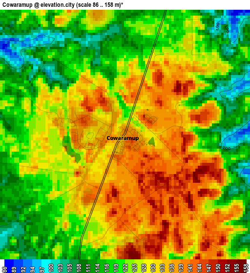
Below is the Elevation map of Cowaramup, which displays elevation range with different colors. Scale of the first map is from 86 to 158 m (282 to 518 ft) with average elevation of 125.2 meters (=411 ft) [note 1]
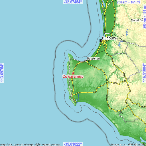
These maps also provides idea of topography and contour of this city, they are displayed at different zoom levels. More info about maps, scale and edge coordinates you can find below images.
| \ | Map #1 | Topo.Map |
| Scale [m] | 86..158 m | × |
| Scale [ft] | 282..518 ft | × |
| Average | 125.2 m = 411 ft | × |
| Width | 8.12 km = 5 mi | 259.7 km = 161.4 mi |
| Height | 8.12 km = 5 mi | 259.7 km = 161.4 mi |
| ↑Max Latitude | -33.813856° | -32.67454° |
| Latitude at center | -33.85036° | -33.85036° |
| ↓Min Latitude | -33.886849° | -35.01022° |
| ← Min Longitude | 115.059845° | 113.69754° |
| Longitude center | 115.10379° | 115.10379° |
| →Max Longitude | 115.147735° | 116.51004° |
Nearby cities:
Cities around Cowaramup sort by population:
• Busselton elevation 1 m
31.4 km,  45°
45°
• West Busselton 6 m
29.5 km,  43°
43°
• Margaret River 98 m
11.9 km,  192°
192°
• Dunsborough 14 m
26.2 km,  0°
0°
• Broadwater 8 m
26.7 km, 38°
• Geographe 5 m
34.9 km, 47°
• Yalyalup 16 m
34.7 km,  55°
55°
• Vasse 6 m
23.1 km, 40°
• Busselton city cenre 1 m
31.7 km, 45°
• Quindalup 11 m
24.2 km,  9°
9°
• Abbey 5 m
25.1 km,  34°
34°
• Yallingup 61 m
23.6 km,  344°
344°
Multilingual:
 En español:
Cowaramup elevación 141 m.
 En France:
Cowaramup élévation 141 m.
 Auf Deutsch:
Cowaramup höhe über dem Meeresspiegel ist 141 m.

Sources and notes:
- [note 1] Map square and city borders are not equal. Map elevation data is calculated only from area inside that square.
- [src 1] Elevation data from geonames database provided with same terms of usage.
- [src 2] The elevation map of Cowaramup is generated using elevation data from NASA's 3 arcsec (90m) resolution SRTM data.
- [src 3] Base (background) map © OpenStreetMap contributors tiles are generated by Geofabrik and OpenTopoMap.
Copyright & License:
This Cowaramup Elevation Map is licensed under CC BY-SA. You may reuse any part from this page, if you give a proper credit by linking to this URL:
 More info on terms of use page.