Mount Isa elevation
Mount Isa (Queensland), Australia elevation is 431 meters and Mount Isa elevation in feet is 1414 ft above sea level [src 1]. Mount Isa is a seat of a second-order administrative division (feature code) with elevation that is 318 meters (1043 ft) bigger than average city elevation in Australia.
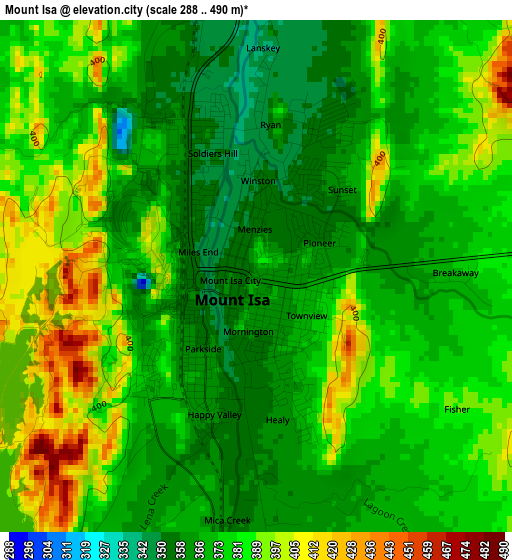
Below is the Elevation map of Mount Isa, which displays elevation range with different colors. Scale of the first map is from 288 to 490 m (945 to 1608 ft) with average elevation of 377.5 meters (=1239 ft) [note 1]
These maps also provides idea of topography and contour of this city, they are displayed at different zoom levels. More info about maps, scale and edge coordinates you can find below images.
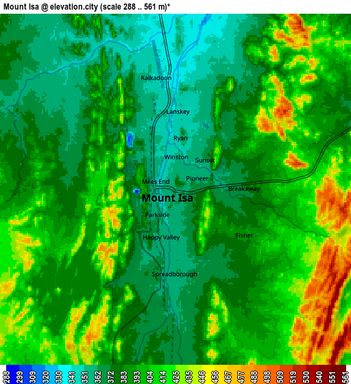
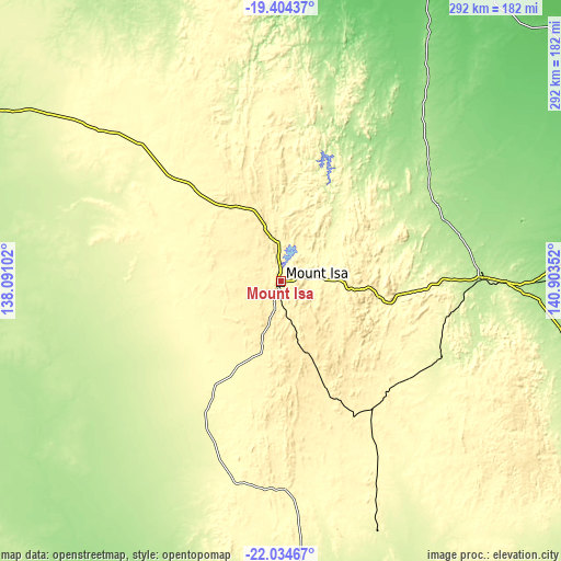
| \ | Map #1 | Map #2 | Topo.Map |
| Scale [m] | 288..490 m | 288..561 m | × |
| Scale [ft] | 945..1608 ft | 945..1841 ft | × |
| Average | 377.5 m = 1239 ft | 391.9 m = 1286 ft | × |
| Width | 9.14 km = 5.7 mi | 18.28 km = 11.4 mi | 292.5 km = 181.8 mi |
| Height | 9.14 km = 5.7 mi | 18.28 km = 11.4 mi | 292.5 km = 181.8 mi |
| ↑Max Latitude | -20.684123° | -20.643005° | -19.40437° |
| Latitude at center | -20.72523° | -20.72523° | -20.72523° |
| ↓Min Latitude | -20.766326° | -20.807411° | -22.03467° |
| ← Min Longitude | 139.453325° | 139.409379° | 138.09102° |
| Longitude center | 139.49727° | 139.49727° | 139.49727° |
| →Max Longitude | 139.541215° | 139.585161° | 140.90352° |
Nearby cities:
Cities around Mount Isa sort by population:
• Cloncurry elevation 197 m
105.7 km,  88°
88°
• Sunset 358 m
2 km,  34°
34°
• Pioneer 357 m
1.3 km,  64°
64°
• Townview 369 m
1.1 km,  135°
135°
• Mornington 358 m
1 km,  188°
188°
• Soldiers Hill 347 m
2.3 km,  340°
340°
• Healy 362 m
2.3 km,  172°
172°
• Normanton 12 m
377.9 km, 26°
• Parkside 357 m
1.7 km,  212°
212°
• Doomadgee 48 m
317.2 km,  347°
347°
• Winston 353 m
2.4 km,  4°
4°
• Menzies 355 m
0.8 km,  359°
359°
Multilingual:
 En español:
Mount Isa elevación 431 m.
 En France:
Mont Isa élévation 431 m.
 Auf Deutsch:
Mount Isa höhe über dem Meeresspiegel ist 431 m.

Sources and notes:
- [note 1] Map square and city borders are not equal. Map elevation data is calculated only from area inside that square.
- [src 1] Elevation data from geonames database provided with same terms of usage.
- [src 2] The elevation map of Mount Isa is generated using elevation data from NASA's 3 arcsec (90m) resolution SRTM data.
- [src 3] Base (background) map © OpenStreetMap contributors tiles are generated by Geofabrik and OpenTopoMap.
Copyright & License:
This Mount Isa Elevation Map is licensed under CC BY-SA. You may reuse any part from this page, if you give a proper credit by linking to this URL:
 More info on terms of use page.