Unley elevation
Unley (South Australia), Australia elevation is 44 meters and Unley elevation in feet is 144 ft above sea level [src 1]. Unley is a section of populated place (feature code) with elevation that is 69 meters (226 ft) smaller than average city elevation in Australia.
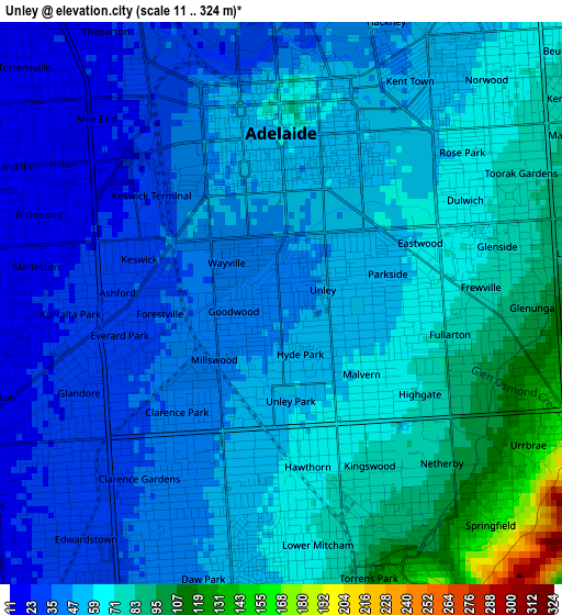
Below is the Elevation map of Unley, which displays elevation range with different colors. Scale of the first map is from 11 to 324 m (36 to 1063 ft) with average elevation of 57.1 meters (=187 ft) [note 1]
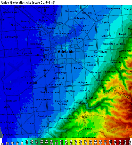
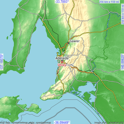
These maps also provides idea of topography and contour of this city, they are displayed at different zoom levels. More info about maps, scale and edge coordinates you can find below images.
| \ | Map #1 | Map #2 | Topo.Map |
| Scale [m] | 11..324 m | 0..546 m | × |
| Scale [ft] | 36..1063 ft | 0..1791 ft | × |
| Average | 57.1 m = 187 ft | 103.4 m = 339 ft | × |
| Width | 8.01 km = 5 mi | 16.02 km = 10 mi | 256.3 km = 159.3 mi |
| Height | 8.01 km = 5 mi | 16.02 km = 10 mi | 256.3 km = 159.3 mi |
| ↑Max Latitude | -34.913972° | -34.877929° | -33.7893° |
| Latitude at center | -34.95° | -34.95° | -34.95° |
| ↓Min Latitude | -34.986012° | -35.022008° | -36.09449° |
| ← Min Longitude | 138.556055° | 138.512109° | 137.19375° |
| Longitude center | 138.6° | 138.6° | 138.6° |
| →Max Longitude | 138.643945° | 138.687891° | 140.00625° |
Nearby cities:
Cities around Unley sort by population:
• Adelaide city centre elevation 58 m
2.4 km,  7°
7°
• Parkside 53 m
1.3 km,  65°
65°
• Goodwood 40 m
0.7 km,  261°
261°
• Malvern 62 m
1.5 km,  131°
131°
• Millswood 42 m
1.2 km,  241°
241°
• Wayville 37 m
1 km,  306°
306°
• Hyde Park 48 m
0.5 km,  169°
169°
• Highgate 74 m
2.4 km,  123°
123°
• Unley Park 63 m
1.7 km,  155°
155°
• Forestville 33 m
2 km,  271°
271°
• Ashford 32 m
2.3 km, 273°
• Everard Park 31 m
2.3 km, 264°
Multilingual:
 En español:
Unley elevación 44 m.
 En France:
Unley élévation 44 m.


Sources and notes:
- [note 1] Map square and city borders are not equal. Map elevation data is calculated only from area inside that square.
- [src 1] Elevation data from geonames database provided with same terms of usage.
- [src 2] The elevation map of Unley is generated using elevation data from NASA's 3 arcsec (90m) resolution SRTM data.
- [src 3] Base (background) map © OpenStreetMap contributors tiles are generated by Geofabrik and OpenTopoMap.
Copyright & License:
This Unley Elevation Map is licensed under CC BY-SA. You may reuse any part from this page, if you give a proper credit by linking to this URL:
 More info on terms of use page.