Hinterleiten elevation
Hinterleiten (Lower Austria, Politischer Bezirk Sankt Pölten), Austria elevation is 368 meters and Hinterleiten elevation in feet is 1207 ft above sea level [src 1]. Hinterleiten is a populated place (feature code) with elevation that is 141 meters (463 ft) smaller than average city elevation in Austria.
Below is the Elevation map of Hinterleiten, which displays elevation range with different colors. Scale of the first map is from 229 to 622 m (751 to 2041 ft) with average elevation of 386.4 meters (=1268 ft) [note 1]
These maps also provides idea of topography and contour of this city, they are displayed at different zoom levels. More info about maps, scale and edge coordinates you can find below images.
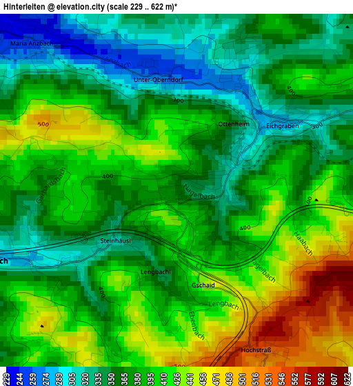
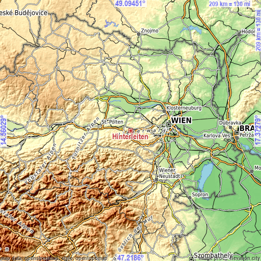
| \ | Map #1 | Topo.Map |
| Scale [m] | 229..622 m | × |
| Scale [ft] | 751..2041 ft | × |
| Average | 386.4 m = 1268 ft | × |
| Width | 6.52 km = 4.1 mi | 208.6 km = 129.6 mi |
| Height | 6.52 km = 4.1 mi | 208.6 km = 129.6 mi |
| ↑Max Latitude | 48.194433° | 49.09451° |
| Latitude at center | 48.16513° | 48.16513° |
| ↓Min Latitude | 48.135811° | 47.2186° |
| ← Min Longitude | 15.922595° | 14.56029° |
| Longitude center | 15.96654° | 15.96654° |
| →Max Longitude | 16.010485° | 17.37279° |
Nearby cities:
Cities around Hinterleiten sort by population:
• Pressbaum elevation 317 m
8.9 km,  76°
76°
• Sieghartskirchen 198 m
10.6 km,  18°
18°
• Klausen-Leopoldsdorf 373 m
9.4 km,  156°
156°
• Tullnerbach-Lawies 371 m
9.6 km,  73°
73°
• Neulengbach 229 m
6 km,  306°
306°
• Hutten 278 m
2.1 km,  43°
43°
• Maria-Anzbach 246 m
3.8 km,  316°
316°
• Haag 245 m
5.6 km,  300°
300°
• Altlengbach 284 m
3.3 km,  246°
246°
• Kirchstetten 263 m
11.3 km,  280°
280°
• Asperhofen 207 m
9.5 km,  341°
341°
• Eichgraben 294 m
1.5 km,  59°
59°
Multilingual:
 En español:
Hinterleiten elevación 368 m.
 En France:
Hinterleiten élévation 368 m.
 Auf Deutsch:
Hinterleiten höhe über dem Meeresspiegel ist 368 m.

Sources and notes:
- [note 1] Map square and city borders are not equal. Map elevation data is calculated only from area inside that square.
- [src 1] Elevation data from geonames database provided with same terms of usage.
- [src 2] The elevation map of Hinterleiten is generated using elevation data from NASA's 3 arcsec (90m) resolution SRTM data.
- [src 3] Base (background) map © OpenStreetMap contributors tiles are generated by Geofabrik and OpenTopoMap.
Copyright & License:
This Hinterleiten Elevation Map is licensed under CC BY-SA. You may reuse any part from this page, if you give a proper credit by linking to this URL:
 More info on terms of use page.