Sieghartskirchen elevation
Sieghartskirchen (Lower Austria, Politischer Bezirk Tulln), Austria elevation is 198 meters and Sieghartskirchen elevation in feet is 650 ft above sea level [src 1]. Sieghartskirchen is a seat of a third-order administrative division (feature code) with elevation that is 311 meters (1020 ft) smaller than average city elevation in Austria.
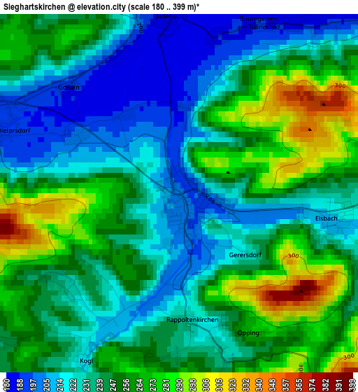
Below is the Elevation map of Sieghartskirchen, which displays elevation range with different colors. Scale of the first map is from 180 to 399 m (591 to 1309 ft) with average elevation of 244.1 meters (=801 ft) [note 1]
These maps also provides idea of topography and contour of this city, they are displayed at different zoom levels. More info about maps, scale and edge coordinates you can find below images.
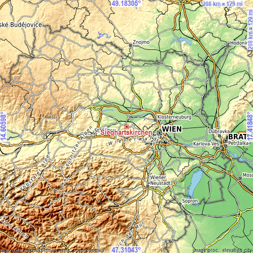
| \ | Map #1 | Topo.Map |
| Scale [m] | 180..399 m | × |
| Scale [ft] | 591..1309 ft | × |
| Average | 244.1 m = 801 ft | × |
| Width | 6.51 km = 4 mi | 208.2 km = 129.4 mi |
| Height | 6.51 km = 4 mi | 208.2 km = 129.4 mi |
| ↑Max Latitude | 48.284561° | 49.18305° |
| Latitude at center | 48.25531° | 48.25531° |
| ↓Min Latitude | 48.226042° | 47.31043° |
| ← Min Longitude | 15.968285° | 14.60598° |
| Longitude center | 16.01223° | 16.01223° |
| →Max Longitude | 16.056175° | 17.41848° |
Nearby cities:
Cities around Sieghartskirchen sort by population:
• Tulln elevation 175 m
8.8 km,  22°
22°
• Pressbaum 317 m
9.6 km,  146°
146°
• Tullnerbach-Lawies 371 m
9.4 km,  141°
141°
• Hutten 278 m
8.8 km,  192°
192°
• Maria-Anzbach 246 m
9.4 km,  219°
219°
• Langenrohr 179 m
5.5 km,  358°
358°
• Michelhausen 189 m
6.7 km,  306°
306°
• Katzelsdorf 204 m
7.8 km,  65°
65°
• Tulbing 183 m
9.2 km,  62°
62°
• Atzenbrugg 191 m
8.8 km,  296°
296°
• Asperhofen 207 m
6.5 km,  260°
260°
• Eichgraben 294 m
9.5 km, 192°
Multilingual:
 En español:
Sieghartskirchen elevación 198 m.
 En France:
Sieghartskirchen élévation 198 m.
 Auf Deutsch:
Sieghartskirchen höhe über dem Meeresspiegel ist 198 m.

Sources and notes:
- [note 1] Map square and city borders are not equal. Map elevation data is calculated only from area inside that square.
- [src 1] Elevation data from geonames database provided with same terms of usage.
- [src 2] The elevation map of Sieghartskirchen is generated using elevation data from NASA's 3 arcsec (90m) resolution SRTM data.
- [src 3] Base (background) map © OpenStreetMap contributors tiles are generated by Geofabrik and OpenTopoMap.
Copyright & License:
This Sieghartskirchen Elevation Map is licensed under CC BY-SA. You may reuse any part from this page, if you give a proper credit by linking to this URL:
 More info on terms of use page.