Altlichtenberg elevation
Altlichtenberg (Upper Austria, Politischer Bezirk Urfahr-Umgebung), Austria elevation is 622 meters and Altlichtenberg elevation in feet is 2041 ft above sea level [src 1]. Altlichtenberg is a populated place (feature code) with elevation that is 113 meters (371 ft) bigger than average city elevation in Austria.
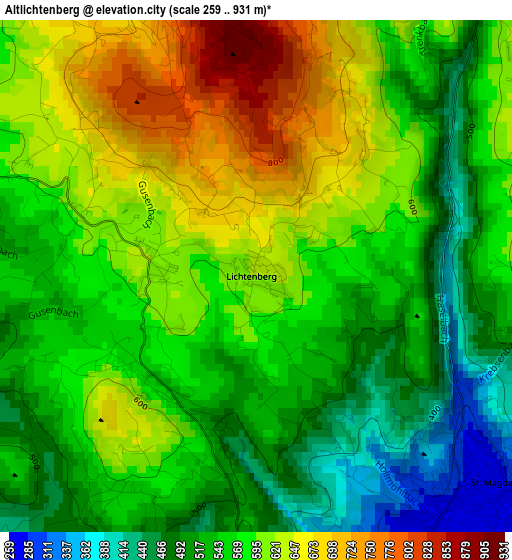
Below is the Elevation map of Altlichtenberg, which displays elevation range with different colors. Scale of the first map is from 259 to 931 m (850 to 3054 ft) with average elevation of 570.1 meters (=1870 ft) [note 1]
These maps also provides idea of topography and contour of this city, they are displayed at different zoom levels. More info about maps, scale and edge coordinates you can find below images.
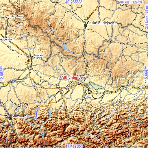
| \ | Map #1 | Topo.Map |
| Scale [m] | 259..931 m | × |
| Scale [ft] | 850..3054 ft | × |
| Average | 570.1 m = 1870 ft | × |
| Width | 6.49 km = 4 mi | 207.8 km = 129.1 mi |
| Height | 6.49 km = 4 mi | 207.8 km = 129.1 mi |
| ↑Max Latitude | 48.389201° | 49.28583° |
| Latitude at center | 48.36001° | 48.36001° |
| ↓Min Latitude | 48.330802° | 47.41705° |
| ← Min Longitude | 14.214505° | 12.8522° |
| Longitude center | 14.25845° | 14.25845° |
| →Max Longitude | 14.302395° | 15.6647° |
Nearby cities:
Cities around Altlichtenberg sort by population:
• Linz elevation 268 m
6.3 km,  161°
161°
• Walding 277 m
7.5 km,  263°
263°
• Ottensheim 269 m
6.9 km,  243°
243°
• Puchenau 288 m
5.6 km,  197°
197°
• Gramastetten 526 m
5.4 km,  294°
294°
• Hellmonsödt 819 m
8.7 km,  20°
20°
• Berg 368 m
7.5 km,  186°
186°
• Mittertreffling 360 m
8.2 km,  106°
106°
• Altenberg bei Linz 586 m
6.9 km,  78°
78°
• Plesching 253 m
7.3 km,  126°
126°
• Eidenberg 688 m
4.3 km,  333°
333°
• Kirchschlag bei Linz 893 m
5.9 km,  13°
13°
Multilingual:
 En español:
Altlichtenberg elevación 622 m.
 En France:
Altlichtenberg élévation 622 m.
 Auf Deutsch:
Altlichtenberg höhe über dem Meeresspiegel ist 622 m.

Sources and notes:
- [note 1] Map square and city borders are not equal. Map elevation data is calculated only from area inside that square.
- [src 1] Elevation data from geonames database provided with same terms of usage.
- [src 2] The elevation map of Altlichtenberg is generated using elevation data from NASA's 3 arcsec (90m) resolution SRTM data.
- [src 3] Base (background) map © OpenStreetMap contributors tiles are generated by Geofabrik and OpenTopoMap.
Copyright & License:
This Altlichtenberg Elevation Map is licensed under CC BY-SA. You may reuse any part from this page, if you give a proper credit by linking to this URL:
 More info on terms of use page.