Bad Gleichenberg elevation
Bad Gleichenberg (Styria, Politischer Bezirk Südoststeiermark), Austria elevation is 295 meters and Bad Gleichenberg elevation in feet is 968 ft above sea level [src 1]. Bad Gleichenberg is a seat of a third-order administrative division (feature code) with elevation that is 214 meters (702 ft) smaller than average city elevation in Austria.
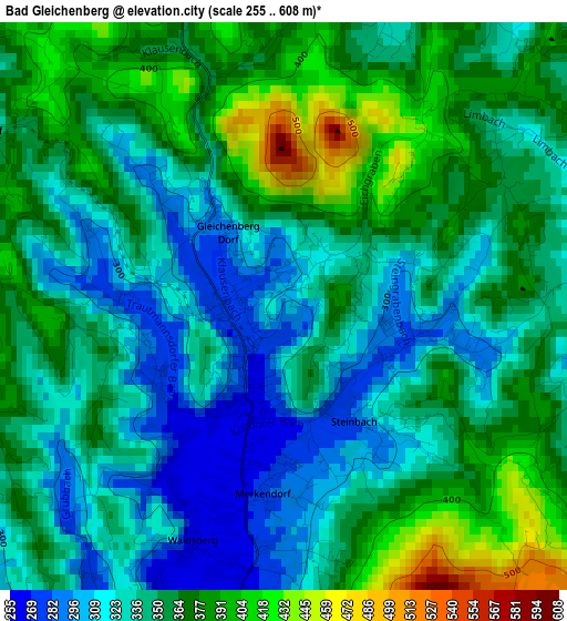
Below is the Elevation map of Bad Gleichenberg, which displays elevation range with different colors. Scale of the first map is from 255 to 608 m (837 to 1995 ft) with average elevation of 350.5 meters (=1150 ft) [note 1]
These maps also provides idea of topography and contour of this city, they are displayed at different zoom levels. More info about maps, scale and edge coordinates you can find below images.
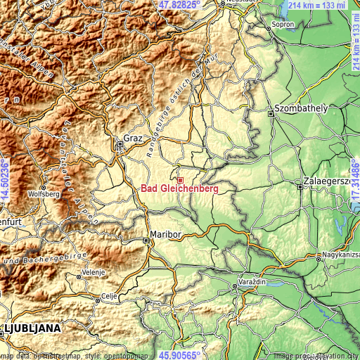
| \ | Map #1 | Topo.Map |
| Scale [m] | 255..608 m | × |
| Scale [ft] | 837..1995 ft | × |
| Average | 350.5 m = 1150 ft | × |
| Width | 6.68 km = 4.2 mi | 213.8 km = 132.8 mi |
| Height | 6.68 km = 4.2 mi | 213.8 km = 132.8 mi |
| ↑Max Latitude | 46.905592° | 47.82825° |
| Latitude at center | 46.87556° | 46.87556° |
| ↓Min Latitude | 46.845511° | 45.90565° |
| ← Min Longitude | 15.864665° | 14.50236° |
| Longitude center | 15.90861° | 15.90861° |
| →Max Longitude | 15.952555° | 17.31486° |
Nearby cities:
Cities around Bad Gleichenberg sort by population:
• Mühldorf bei Feldbach elevation 291 m
7 km,  359°
359°
• Bairisch Kölldorf 385 m
2.1 km,  117°
117°
• Gnas 276 m
6.3 km,  267°
267°
• Trautmannsdorf in Oststeiermark 281 m
1.8 km, 269°
• Gossendorf 317 m
4.3 km,  22°
22°
• Kapfenstein 302 m
4.9 km,  76°
76°
• Merkendorf 266 m
2.1 km,  189°
189°
• Poppendorf 308 m
4.5 km,  241°
241°
• Stainz bei Straden 251 m
5.8 km, 192°
• Krusdorf 272 m
5.4 km,  222°
222°
• Maierdorf 316 m
4.9 km,  292°
292°
• Sankt Anna am Aigen 365 m
6.9 km,  135°
135°
Multilingual:
 En español:
Bad Gleichenberg elevación 295 m.
 En France:
Bad Gleichenberg élévation 295 m.
 Auf Deutsch:
Bad Gleichenberg höhe über dem Meeresspiegel ist 295 m.

Sources and notes:
- [note 1] Map square and city borders are not equal. Map elevation data is calculated only from area inside that square.
- [src 1] Elevation data from geonames database provided with same terms of usage.
- [src 2] The elevation map of Bad Gleichenberg is generated using elevation data from NASA's 3 arcsec (90m) resolution SRTM data.
- [src 3] Base (background) map © OpenStreetMap contributors tiles are generated by Geofabrik and OpenTopoMap.
Copyright & License:
This Bad Gleichenberg Elevation Map is licensed under CC BY-SA. You may reuse any part from this page, if you give a proper credit by linking to this URL:
 More info on terms of use page.