Kapfenstein elevation
Kapfenstein (Styria, Politischer Bezirk Südoststeiermark), Austria elevation is 302 meters and Kapfenstein elevation in feet is 991 ft above sea level [src 1]. Kapfenstein is a seat of a third-order administrative division (feature code) with elevation that is 207 meters (679 ft) smaller than average city elevation in Austria.
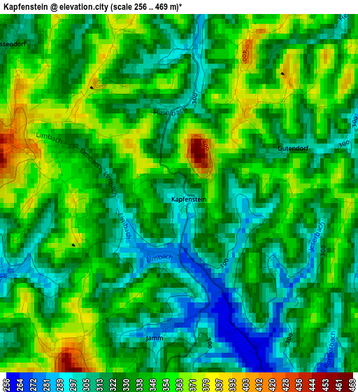
Below is the Elevation map of Kapfenstein, which displays elevation range with different colors. Scale of the first map is from 256 to 469 m (840 to 1539 ft) with average elevation of 335.2 meters (=1100 ft) [note 1]
These maps also provides idea of topography and contour of this city, they are displayed at different zoom levels. More info about maps, scale and edge coordinates you can find below images.
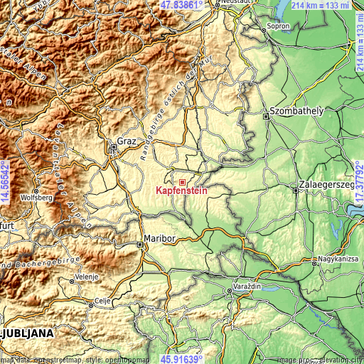
| \ | Map #1 | Topo.Map |
| Scale [m] | 256..469 m | × |
| Scale [ft] | 840..1539 ft | × |
| Average | 335.2 m = 1100 ft | × |
| Width | 6.68 km = 4.2 mi | 213.7 km = 132.8 mi |
| Height | 6.68 km = 4.2 mi | 213.7 km = 132.8 mi |
| ↑Max Latitude | 46.916136° | 47.83861° |
| Latitude at center | 46.88611° | 46.88611° |
| ↓Min Latitude | 46.856067° | 45.91639° |
| ← Min Longitude | 15.927725° | 14.56542° |
| Longitude center | 15.97167° | 15.97167° |
| →Max Longitude | 16.015615° | 17.37792° |
Nearby cities:
Cities around Kapfenstein sort by population:
• Mühldorf bei Feldbach elevation 291 m
7.6 km,  320°
320°
• Fehring 260 m
6.6 km,  24°
24°
• Bad Gleichenberg 295 m
4.9 km,  256°
256°
• Bairisch Kölldorf 385 m
3.6 km,  233°
233°
• Pertlstein 269 m
6.1 km,  352°
352°
• Trautmannsdorf in Oststeiermark 281 m
6.7 km, 259°
• Leitersdorf im Raabtal 285 m
6.8 km,  335°
335°
• Gossendorf 317 m
4.2 km,  311°
311°
• Neuhaus am Klausenbach 312 m
5.2 km,  114°
114°
• Mühlgraben 314 m
5.3 km,  85°
85°
• Merkendorf 266 m
6.1 km,  238°
238°
• Sankt Anna am Aigen 365 m
6.1 km,  180°
180°
Multilingual:
 En español:
Kapfenstein elevación 302 m.
 En France:
Kapfenstein élévation 302 m.
 Auf Deutsch:
Kapfenstein höhe über dem Meeresspiegel ist 302 m.

Sources and notes:
- [note 1] Map square and city borders are not equal. Map elevation data is calculated only from area inside that square.
- [src 1] Elevation data from geonames database provided with same terms of usage.
- [src 2] The elevation map of Kapfenstein is generated using elevation data from NASA's 3 arcsec (90m) resolution SRTM data.
- [src 3] Base (background) map © OpenStreetMap contributors tiles are generated by Geofabrik and OpenTopoMap.
Copyright & License:
This Kapfenstein Elevation Map is licensed under CC BY-SA. You may reuse any part from this page, if you give a proper credit by linking to this URL:
 More info on terms of use page.