Deutschlandsberg elevation
Deutschlandsberg (Styria, Politischer Bezirk Deutschlandsberg), Austria elevation is 362 meters and Deutschlandsberg elevation in feet is 1188 ft above sea level [src 1]. Deutschlandsberg is a seat of a third-order administrative division (feature code) with elevation that is 147 meters (482 ft) smaller than average city elevation in Austria.
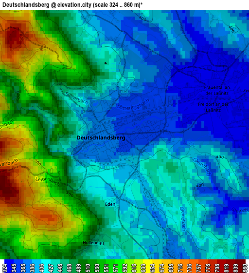
Below is the Elevation map of Deutschlandsberg, which displays elevation range with different colors. Scale of the first map is from 324 to 860 m (1063 to 2822 ft) with average elevation of 453.8 meters (=1489 ft) [note 1]
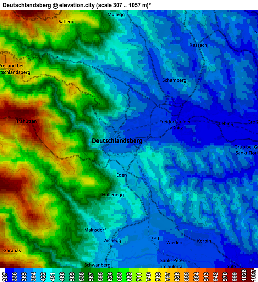
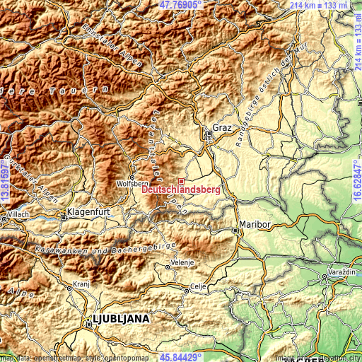
These maps also provides idea of topography and contour of this city, they are displayed at different zoom levels. More info about maps, scale and edge coordinates you can find below images.
| \ | Map #1 | Map #2 | Topo.Map |
| Scale [m] | 324..860 m | 307..1057 m | × |
| Scale [ft] | 1063..2822 ft | 1007..3468 ft | × |
| Average | 453.8 m = 1489 ft | 500.9 m = 1643 ft | × |
| Width | 6.69 km = 4.2 mi | 13.38 km = 8.3 mi | 214 km = 133 mi |
| Height | 6.69 km = 4.2 mi | 13.38 km = 8.3 mi | 214 km = 133 mi |
| ↑Max Latitude | 46.845346° | 46.875395° | 47.76905° |
| Latitude at center | 46.81528° | 46.81528° | 46.81528° |
| ↓Min Latitude | 46.785197° | 46.755098° | 45.84429° |
| ← Min Longitude | 15.178275° | 15.134329° | 13.81597° |
| Longitude center | 15.22222° | 15.22222° | 15.22222° |
| →Max Longitude | 15.266165° | 15.310111° | 16.62847° |
Nearby cities:
Cities around Deutschlandsberg sort by population:
• Schwanberg elevation 401 m
6.4 km,  189°
189°
• Freidorf an der Laßnitz 341 m
2.1 km,  85°
85°
• Groß Sankt Florian 309 m
7.4 km,  82°
82°
• Bad Gams 413 m
6.2 km,  1°
1°
• Sankt Peter im Sulmtal 410 m
7.6 km,  163°
163°
• Rassach 382 m
6.2 km,  35°
35°
• Gressenberg 1122 m
8.2 km,  258°
258°
• Unterbergla 345 m
7.1 km,  97°
97°
• Hollenegg 470 m
2.7 km, 194°
• Trahütten 972 m
5.1 km,  282°
282°
• Freiland bei Deutschlandsberg 843 m
7.1 km,  286°
286°
• Sankt Martin im Sulmtal 336 m
8.7 km,  139°
139°
Multilingual:
 En español:
Deutschlandsberg elevación 362 m.
 En France:
Deutschlandsberg élévation 362 m.
 Auf Deutsch:
Deutschlandsberg höhe über dem Meeresspiegel ist 362 m.

Sources and notes:
- [note 1] Map square and city borders are not equal. Map elevation data is calculated only from area inside that square.
- [src 1] Elevation data from geonames database provided with same terms of usage.
- [src 2] The elevation map of Deutschlandsberg is generated using elevation data from NASA's 3 arcsec (90m) resolution SRTM data.
- [src 3] Base (background) map © OpenStreetMap contributors tiles are generated by Geofabrik and OpenTopoMap.
Copyright & License:
This Deutschlandsberg Elevation Map is licensed under CC BY-SA. You may reuse any part from this page, if you give a proper credit by linking to this URL:
 More info on terms of use page.