Dürnkrut elevation
Dürnkrut (Lower Austria, Politischer Bezirk Gänserndorf), Austria elevation is 152 meters and Dürnkrut elevation in feet is 499 ft above sea level [src 1]. Dürnkrut is a seat of a third-order administrative division (feature code) with elevation that is 357 meters (1171 ft) smaller than average city elevation in Austria.
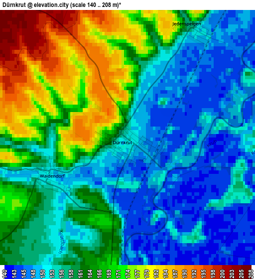
Below is the Elevation map of Dürnkrut, which displays elevation range with different colors. Scale of the first map is from 140 to 208 m (459 to 682 ft) with average elevation of 160.8 meters (=528 ft) [note 1]
These maps also provides idea of topography and contour of this city, they are displayed at different zoom levels. More info about maps, scale and edge coordinates you can find below images.
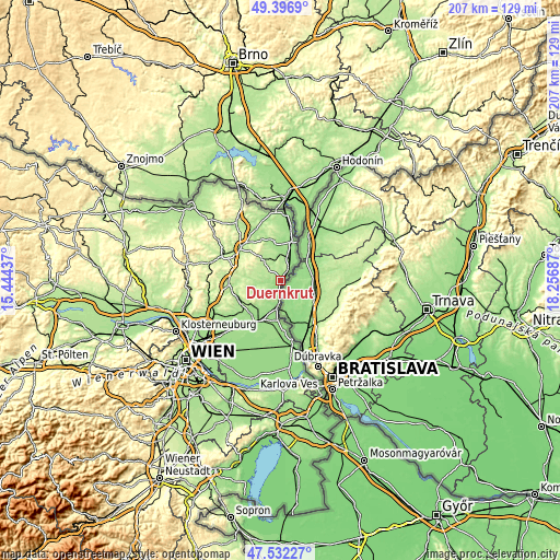
| \ | Map #1 | Topo.Map |
| Scale [m] | 140..208 m | × |
| Scale [ft] | 459..682 ft | × |
| Average | 160.8 m = 528 ft | × |
| Width | 6.48 km = 4 mi | 207.3 km = 128.8 mi |
| Height | 6.48 km = 4 mi | 207.3 km = 128.8 mi |
| ↑Max Latitude | 48.502276° | 49.3969° |
| Latitude at center | 48.47315° | 48.47315° |
| ↓Min Latitude | 48.444007° | 47.53227° |
| ← Min Longitude | 16.806675° | 15.44437° |
| Longitude center | 16.85062° | 16.85062° |
| →Max Longitude | 16.894565° | 18.25687° |
Nearby cities:
Cities around Dürnkrut sort by population:
• Zistersdorf elevation 188 m
10.1 km,  319°
319°
• Hohenau 152 m
15.1 km,  15°
15°
• Matzen 198 m
13.8 km,  233°
233°
• Prottes 164 m
12.7 km,  220°
220°
• Angern an der March 152 m
10.7 km,  188°
188°
• Neusiedl an der Zaya 181 m
15 km,  339°
339°
• Spannberg 170 m
8.5 km,  263°
263°
• Ebenthal 182 m
6.7 km, 228°
• Hohenruppersdorf 213 m
14.6 km,  266°
266°
• Drösing 158 m
8.3 km,  27°
27°
• Jedenspeigen 156 m
3.2 km, 29°
• Hauskirchen 238 m
15.4 km, 336°
Multilingual:
 En español:
Dürnkrut elevación 152 m.
 En France:
Dürnkrut élévation 152 m.
 Auf Deutsch:
Dürnkrut höhe über dem Meeresspiegel ist 152 m.

Sources and notes:
- [note 1] Map square and city borders are not equal. Map elevation data is calculated only from area inside that square.
- [src 1] Elevation data from geonames database provided with same terms of usage.
- [src 2] The elevation map of Dürnkrut is generated using elevation data from NASA's 3 arcsec (90m) resolution SRTM data.
- [src 3] Base (background) map © OpenStreetMap contributors tiles are generated by Geofabrik and OpenTopoMap.
Copyright & License:
This Dürnkrut Elevation Map is licensed under CC BY-SA. You may reuse any part from this page, if you give a proper credit by linking to this URL:
 More info on terms of use page.